![](/images/other/stat-length.png)
![Tour Wandern Courgoul - Le chemin des bergères et le Plateau d'Ussel - Courgoul - Photo](https://media.geolcdn.com/t/1900/400/ext.pjpeg?maxdim=2&url=https%3A%2F%2Fservices.sitytrail.com%2FGeolivesWS%2FDownloadMedia.ashx%3FTrailID%3D106331%26Media%3D10781_4.jpg)
Le chemin des bergères et le Plateau d'Ussel - Courgoul
tracegps
Benutzer
![Länge](/images/other/stat-length.png)
![Maximale Höhe](https://static1.geolcdn.com/siteimages/upload/files/1508320355ic_sort_altitude_max_24dp.png)
![Positive Höhendifferenz](https://static1.geolcdn.com/siteimages/upload/files/1508320355ic_sort_den_pos_24dp.png)
![Km-Effort](/images/other/stat-length.png)
![Min. Höhe](https://static1.geolcdn.com/siteimages/upload/files/1508320355ic_sort_altitude_min_24dp.png)
![Negative Höhendifferenz](https://static1.geolcdn.com/siteimages/upload/files/1508320355ic_sort_den_neg_24dp.png)
![Boucle](https://static1.geolcdn.com/siteimages/upload/files/16400158638029165_repeat_loop_refresh_sync_direction_icon.png)
![Wandern](https://static1.geolcdn.com/sitytour/trail-icons/101.png)
5h00
Schwierigkeit : Schwierig
![Scannen Sie diesen QR-Code, um die Tour in der SityTrail-Anwendung zu öffnen](https://capi.geolives.com/qq0zvz2zws4bq2lad0pu/sitytour/trails/106331/qr.png?size=200)
Kostenlosegpshiking-Anwendung
Über SityTrail
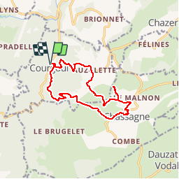
Tour Wandern von 14,5 km verfügbar auf Auvergne-Rhone-Alpen, Puy-de-Dôme, Courgoul. Diese Tour wird von tracegps vorgeschlagen.
Beschreibung
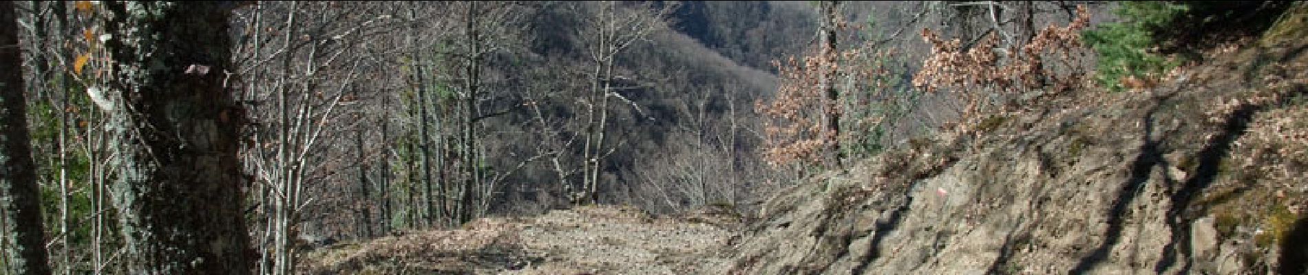
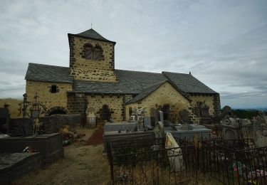
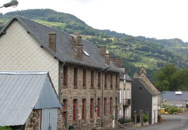
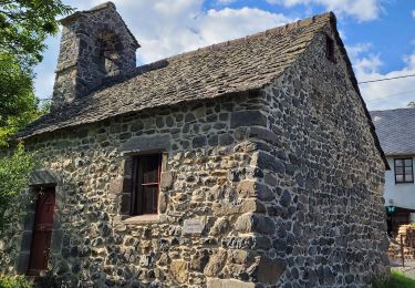
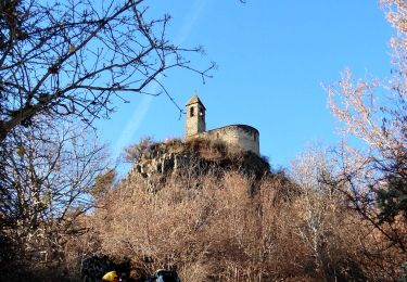
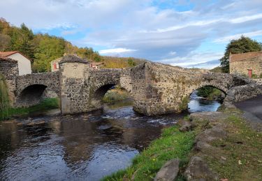
Du fond des gorges de Courgoul on monte par un beau chemin à travers bois de feuillus jusqu'au plateau d'Ussel et le village de Chassagne. De là, on aperçoit à travers les arbres la discrète mais pourtant célèbre abbaye de Mégemont. Au sommet du mamelon d'Ussel (cote 1030), le panorama est exceptionnel sur la Chaîne des Puys, les villages d'Olloix et Montaigut, le pic Brionnet avec au sommet la petite chapelle N.D. du Mont Carmel et bien d'autres lieux... Au retour, sur les pentes, houx et broussailles occupent les "paillats", anciennes surfaces cultivées en étages. Sur le versant Ouest de Courgoul, certains ont fait l'objet de réhabilitation.
Ort
Kommentare
Touren in der Umgebung
![Tour Zu Fuß Dauzat-sur-Vodable - Dauzat-sur-Vodable - Photo](https://media.geolcdn.com/t/375/260/d172e481-65da-4881-bd03-f6cc99def315.jpeg&format=jpg&maxdim=2)
![Zu Fuß Zu Fuß](https://static1.geolcdn.com/sitytour/trail-icons/100.png)
Zu Fuß
![](/images/other/stat-length.png)
![](https://static1.geolcdn.com/siteimages/upload/files/16400158638029165_repeat_loop_refresh_sync_direction_icon.png)
![Tour Zu Fuß Saint-Diéry - Le Cheix - Photo](https://media.geolcdn.com/t/375/260/cef373ab-41f4-493d-8694-97c838874352.jpeg&format=jpg&maxdim=2)
![Zu Fuß Zu Fuß](https://static1.geolcdn.com/sitytour/trail-icons/100.png)
Zu Fuß
![](/images/other/stat-length.png)
![](https://static1.geolcdn.com/siteimages/upload/files/16400158638029165_repeat_loop_refresh_sync_direction_icon.png)
![Tour Zu Fuß Valbeleix - Le Plateau de la Chavade et la Roche Nite - Photo](https://media.geolcdn.com/t/375/260/a467407f-a0fb-4883-8852-b6255f6151df.jpeg&format=jpg&maxdim=2)
![Zu Fuß Zu Fuß](https://static1.geolcdn.com/sitytour/trail-icons/100.png)
Zu Fuß
![](/images/other/stat-length.png)
![](https://static1.geolcdn.com/siteimages/upload/files/16400158638029165_repeat_loop_refresh_sync_direction_icon.png)
![Tour Zu Fuß Saurier - Le Pic de Brionnet - Photo](https://media.geolcdn.com/t/375/260/6e33ab27-c788-4f32-8c30-5bc1de6dd66f.jpeg&format=jpg&maxdim=2)
![Zu Fuß Zu Fuß](https://static1.geolcdn.com/sitytour/trail-icons/100.png)
Zu Fuß
![](/images/other/stat-length.png)
![](https://static1.geolcdn.com/siteimages/upload/files/16400158638029165_repeat_loop_refresh_sync_direction_icon.png)
![Tour Wandern Courgoul - Les-Gorges-de-Courgoul-Marcenat_T - Photo](https://media.geolcdn.com/t/375/260/78d4684c-2220-458c-aac4-f2b1ac8cba79.jpg&format=jpg&maxdim=2)
![Wandern Wandern](https://static1.geolcdn.com/sitytour/trail-icons/101.png)
Wandern
![](/images/other/stat-length.png)
![](https://static1.geolcdn.com/siteimages/upload/files/16400158638029165_repeat_loop_refresh_sync_direction_icon.png)
![Tour Wandern Saint-Diéry - St_Diery_Mont_Carmel - Photo](https://media.geolcdn.com/t/375/260/3e3b4de8-74a3-4fde-8693-784ab1979488.jpg&format=jpg&maxdim=2)
![Wandern Wandern](https://static1.geolcdn.com/sitytour/trail-icons/101.png)
Wandern
![](/images/other/stat-length.png)
![](https://static1.geolcdn.com/siteimages/upload/files/16400158638029165_repeat_loop_refresh_sync_direction_icon.png)
![Tour Zu Fuß Saint-Diéry - Cotteuge - Photo](https://media.geolcdn.com/t/375/260/cef373ab-41f4-493d-8694-97c838874352.jpeg&format=jpg&maxdim=2)
![Zu Fuß Zu Fuß](https://static1.geolcdn.com/sitytour/trail-icons/100.png)
Zu Fuß
![](/images/other/stat-length.png)
![](https://static1.geolcdn.com/siteimages/upload/files/16400158638029165_repeat_loop_refresh_sync_direction_icon.png)
![Tour Zu Fuß Chassagne - Le Plateau d'Ussel - Photo](https://media.geolcdn.com/t/375/260/56405ee6-4d93-4498-a458-c552d564104f.jpeg&format=jpg&maxdim=2)
![Zu Fuß Zu Fuß](https://static1.geolcdn.com/sitytour/trail-icons/100.png)
Zu Fuß
![](/images/other/stat-length.png)
![](https://static1.geolcdn.com/siteimages/upload/files/16400158638029165_repeat_loop_refresh_sync_direction_icon.png)
![Tour Wandern Saurier - Saurier-Brionnet_T - Photo](https://media.geolcdn.com/t/375/260/ba5c2247-984d-4737-ae94-96b595088246.jpg&format=jpg&maxdim=2)
![Wandern Wandern](https://static1.geolcdn.com/sitytour/trail-icons/101.png)
Wandern
![](/images/other/stat-length.png)
![](https://static1.geolcdn.com/siteimages/upload/files/16400158638029165_repeat_loop_refresh_sync_direction_icon.png)