![](/images/other/stat-length.png)
![Tour Mountainbike Alençon - Alençon, La Pesantière, Saint Nicolas des Bois, Cuissai, Beaubourdel - Photo](https://media.geolcdn.com/t/1900/400/ext.pjpeg?maxdim=2&url=https%3A%2F%2Fstatic1.geolcdn.com%2Fsiteimages%2Fupload%2Ffiles%2F1524743154velo.jpg)
Alençon, La Pesantière, Saint Nicolas des Bois, Cuissai, Beaubourdel
tracegps
Benutzer
![Länge](/images/other/stat-length.png)
Länge
26 km
![Maximale Höhe](https://static1.geolcdn.com/siteimages/upload/files/1508320355ic_sort_altitude_max_24dp.png)
Maximale Höhe
316 m
![Positive Höhendifferenz](https://static1.geolcdn.com/siteimages/upload/files/1508320355ic_sort_den_pos_24dp.png)
Positive Höhendifferenz
330 m
![Km-Effort](/images/other/stat-length.png)
Km-Effort
30 km
![Min. Höhe](https://static1.geolcdn.com/siteimages/upload/files/1508320355ic_sort_altitude_min_24dp.png)
Min. Höhe
141 m
![Negative Höhendifferenz](https://static1.geolcdn.com/siteimages/upload/files/1508320355ic_sort_den_neg_24dp.png)
Negative Höhendifferenz
330 m
![Boucle](https://static1.geolcdn.com/siteimages/upload/files/16400158638029165_repeat_loop_refresh_sync_direction_icon.png)
Boucle
Ja
Erstellungsdatum :
2014-12-10 00:00:00.0
Letzte Änderung :
2014-12-10 00:00:00.0
![Mountainbike](https://static1.geolcdn.com/sitytour/trail-icons/202.png)
1h40
Schwierigkeit : Einfach
![Scannen Sie diesen QR-Code, um die Tour in der SityTrail-Anwendung zu öffnen](https://capi.geolives.com/qq0zvz2zws4bq2lad0pu/sitytour/trails/106273/qr.png?size=200)
Kostenlosegpshiking-Anwendung
Über SityTrail
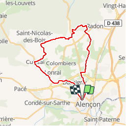
Tour Mountainbike von 26 km verfügbar auf Normandie, Orne, Alençon. Diese Tour wird von tracegps vorgeschlagen.
Beschreibung
Boucle à la lisière de la forêt d'Ecouves, sans réelles difficultés à part la montée par le chemin de la Messe en milieu de parcours. Le retour de Saint Nicolas se fait par la route dans la plaine.
Ort
Land:
France
Region :
Normandie
Abteilung/Provinz :
Orne
Kommune :
Alençon
Standort:
Unknown
Gehen Sie:(Dec)
Gehen Sie:(UTM)
284260 ; 5368730 (31U) N.
Kommentare
Touren in der Umgebung
![Tour Wandern Arçonnay - Arconnay - Photo](https://media.geolcdn.com/t/375/260/ext.jpg?maxdim=2&url=https%3A%2F%2Fstatic1.geolcdn.com%2Fsiteimages%2Fupload%2Ffiles%2F1553511878bg_sport_marche.png)
![Wandern Wandern](https://static1.geolcdn.com/sitytour/trail-icons/101.png)
Arconnay
Wandern
Medium
(1)
Arçonnay,
Pays de la Loire,
Sarthe,
France
![](/images/other/stat-length.png)
25 km | 28 km-effort
5h 28min
![](https://static1.geolcdn.com/siteimages/upload/files/16400158638029165_repeat_loop_refresh_sync_direction_icon.png)
Ja
![Tour Mountainbike Alençon - Montée à la croix de Médavy par route et descente par GR et chemins - Photo](https://media.geolcdn.com/t/375/260/ext.jpg?maxdim=2&url=https%3A%2F%2Fstatic1.geolcdn.com%2Fsiteimages%2Fupload%2Ffiles%2F1524743154velo.jpg)
![Mountainbike Mountainbike](https://static1.geolcdn.com/sitytour/trail-icons/202.png)
Montée à la croix de Médavy par route et descente par GR et chemins
Mountainbike
Einfach
(1)
Alençon,
Normandie,
Orne,
France
![](/images/other/stat-length.png)
33 km | 40 km-effort
1h 34min
![](https://static1.geolcdn.com/siteimages/upload/files/16400158638029165_repeat_loop_refresh_sync_direction_icon.png)
Ja
![Tour Fahrrad Alençon - Véloscénie 3ème étape - Photo](https://media.geolcdn.com/t/375/260/ext.jpg?maxdim=2&url=https%3A%2F%2Fservices.sitytrail.com%2FGeolivesWS%2FDownloadMedia.ashx%3FTrailID%3D636896%26Media%3Dfix__20160913102128.jpg)
![Fahrrad Fahrrad](https://static1.geolcdn.com/sitytour/trail-icons/200.png)
Véloscénie 3ème étape
Fahrrad
Einfach
Alençon,
Normandie,
Orne,
France
![](/images/other/stat-length.png)
116 km | 133 km-effort
7h 29min
![](https://static1.geolcdn.com/siteimages/upload/files/16400158638029165_repeat_loop_refresh_sync_direction_icon.png)
Nein
![Tour Mountainbike Saint-Germain-du-Corbéis - Le bois de vaux - Photo](https://media.geolcdn.com/t/375/260/ext.jpg?maxdim=2&url=https%3A%2F%2Fstatic1.geolcdn.com%2Fsiteimages%2Fupload%2Ffiles%2F1524743154velo.jpg)
![Mountainbike Mountainbike](https://static1.geolcdn.com/sitytour/trail-icons/202.png)
Le bois de vaux
Mountainbike
Medium
(1)
Saint-Germain-du-Corbéis,
Normandie,
Orne,
France
![](/images/other/stat-length.png)
35 km | 39 km-effort
2h 16min
![](https://static1.geolcdn.com/siteimages/upload/files/16400158638029165_repeat_loop_refresh_sync_direction_icon.png)
Ja
![Tour Mountainbike Saint-Germain-du-Corbéis - chapelle St Evroult/château de Vaux - Photo](https://media.geolcdn.com/t/375/260/fa51d126-bad4-43b5-a7f0-d58e2f351ae2.jpg&format=jpg&maxdim=2)
![Mountainbike Mountainbike](https://static1.geolcdn.com/sitytour/trail-icons/202.png)
chapelle St Evroult/château de Vaux
Mountainbike
Medium
(1)
Saint-Germain-du-Corbéis,
Normandie,
Orne,
France
![](/images/other/stat-length.png)
34 km | 39 km-effort
2h 8min
![](https://static1.geolcdn.com/siteimages/upload/files/16400158638029165_repeat_loop_refresh_sync_direction_icon.png)
Ja
![Tour Fahrrad Alençon - Alençon, Héloup, Gesnes le Gandelin, Arçonnay, Alençon - Photo](https://media.geolcdn.com/t/375/260/ext.jpg?maxdim=2&url=https%3A%2F%2Fservices.sitytrail.com%2FGeolivesWS%2FDownloadMedia.ashx%3FTrailID%3D104750%26Media%3D8195_1.jpg)
![Fahrrad Fahrrad](https://static1.geolcdn.com/sitytour/trail-icons/200.png)
Alençon, Héloup, Gesnes le Gandelin, Arçonnay, Alençon
Fahrrad
Medium
Alençon,
Normandie,
Orne,
France
![](/images/other/stat-length.png)
30 km | 33 km-effort
1h 10min
![](https://static1.geolcdn.com/siteimages/upload/files/16400158638029165_repeat_loop_refresh_sync_direction_icon.png)
Ja
![Tour Radtourismus Alençon - La véloscénie - Alencon - Madré - Tronçon 1 - Photo](https://media.geolcdn.com/t/375/260/ext.jpg?maxdim=2&url=https%3A%2F%2Fstatic1.geolcdn.com%2Fsiteimages%2Fupload%2Ffiles%2F1524743154velo.jpg)
![Radtourismus Radtourismus](https://static1.geolcdn.com/sitytour/trail-icons/204.png)
La véloscénie - Alencon - Madré - Tronçon 1
Radtourismus
Sehr schwierig
Alençon,
Normandie,
Orne,
France
![](/images/other/stat-length.png)
40 km | 45 km-effort
Unbekannt
![](https://static1.geolcdn.com/siteimages/upload/files/16400158638029165_repeat_loop_refresh_sync_direction_icon.png)
Nein
![Tour Radtourismus Alençon - Activity - Photo](https://media.geolcdn.com/t/375/260/ext.jpg?maxdim=2&url=https%3A%2F%2Fstatic1.geolcdn.com%2Fsiteimages%2Fupload%2Ffiles%2F1524743154velo.jpg)
![Radtourismus Radtourismus](https://static1.geolcdn.com/sitytour/trail-icons/204.png)
Activity
Radtourismus
Sehr schwierig
Alençon,
Normandie,
Orne,
France
![](/images/other/stat-length.png)
155 km | 173 km-effort
Unbekannt
![](https://static1.geolcdn.com/siteimages/upload/files/16400158638029165_repeat_loop_refresh_sync_direction_icon.png)
Nein
![Tour Wandern Saint-Paterne - Le Chevain - brullemail - Photo](https://media.geolcdn.com/t/375/260/ext.jpg?maxdim=2&url=https%3A%2F%2Fstatic1.geolcdn.com%2Fsiteimages%2Fupload%2Ffiles%2F1553511878bg_sport_marche.png)
![Wandern Wandern](https://static1.geolcdn.com/sitytour/trail-icons/101.png)
brullemail
Wandern
Sehr schwierig
Saint-Paterne - Le Chevain,
Pays de la Loire,
Sarthe,
France
![](/images/other/stat-length.png)
40 km | 46 km-effort
4h 24min
![](https://static1.geolcdn.com/siteimages/upload/files/16400158638029165_repeat_loop_refresh_sync_direction_icon.png)
Nein