![](/images/other/stat-length.png)
![Tour Wandern Raismes - Forêt de Raismes et mare à Goriaux - Raismes - Photo](https://media.geolcdn.com/t/1900/400/ext.pjpeg?maxdim=2&url=https%3A%2F%2Fservices.sitytrail.com%2FGeolivesWS%2FDownloadMedia.ashx%3FTrailID%3D106160%26Media%3D10429_6.jpg)
Forêt de Raismes et mare à Goriaux - Raismes
tracegps
Benutzer
![Länge](/images/other/stat-length.png)
Länge
11,5 km
![Maximale Höhe](https://static1.geolcdn.com/siteimages/upload/files/1508320355ic_sort_altitude_max_24dp.png)
Maximale Höhe
38 m
![Positive Höhendifferenz](https://static1.geolcdn.com/siteimages/upload/files/1508320355ic_sort_den_pos_24dp.png)
Positive Höhendifferenz
93 m
![Km-Effort](/images/other/stat-length.png)
Km-Effort
12,7 km
![Min. Höhe](https://static1.geolcdn.com/siteimages/upload/files/1508320355ic_sort_altitude_min_24dp.png)
Min. Höhe
17 m
![Negative Höhendifferenz](https://static1.geolcdn.com/siteimages/upload/files/1508320355ic_sort_den_neg_24dp.png)
Negative Höhendifferenz
93 m
![Boucle](https://static1.geolcdn.com/siteimages/upload/files/16400158638029165_repeat_loop_refresh_sync_direction_icon.png)
Boucle
Ja
Erstellungsdatum :
2014-12-10 00:00:00.0
Letzte Änderung :
2014-12-10 00:00:00.0
![Wandern](https://static1.geolcdn.com/sitytour/trail-icons/101.png)
3h00
Schwierigkeit : Medium
![Scannen Sie diesen QR-Code, um die Tour in der SityTrail-Anwendung zu öffnen](https://capi.geolives.com/qq0zvz2zws4bq2lad0pu/sitytour/trails/106160/qr.png?size=200)
Kostenlosegpshiking-Anwendung
Über SityTrail
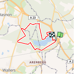
Tour Wandern von 11,5 km verfügbar auf Nordfrankreich, Nord, Raismes. Diese Tour wird von tracegps vorgeschlagen.
Beschreibung
Départ du parking de la mare à Goriaux dans la forêt de Raismes, à proximité de la sortie n°6 de l'autoroute A23. Ce circuit a été numérisé par les randonneurs du CODEPEM.
Ort
Land:
France
Region :
Nordfrankreich
Abteilung/Provinz :
Nord
Kommune :
Raismes
Standort:
Unknown
Gehen Sie:(Dec)
Gehen Sie:(UTM)
531832 ; 5582770 (31U) N.
Kommentare
Touren in der Umgebung
![Tour Wandern Raismes - Circuit du Terril de Sabatier - Photo](https://media.geolcdn.com/t/375/260/ext.jpg?maxdim=2&url=https%3A%2F%2Fservices.sitytrail.com%2FGeolivesWS%2FDownloadMedia.ashx%3FTrailID%3D479716%26Media%3D781031eb-7ab3-4c80-8a0c-0836d5a81ce2.JPG)
![Wandern Wandern](https://static1.geolcdn.com/sitytour/trail-icons/101.png)
Circuit du Terril de Sabatier
Wandern
Einfach
(1)
Raismes,
Nordfrankreich,
Nord,
France
![](/images/other/stat-length.png)
13 km | 14,9 km-effort
2h 34min
![](https://static1.geolcdn.com/siteimages/upload/files/16400158638029165_repeat_loop_refresh_sync_direction_icon.png)
Ja
![Tour Wandern Saint-Amand-les-Eaux - terril vicoigne - Photo](https://media.geolcdn.com/t/375/260/ext.jpg?maxdim=2&url=https%3A%2F%2Fmedia.geolcdn.com%2Ff%2Fd8552856-5959-4bc8-a6d2-93f721ca17ec.jpg)
![Wandern Wandern](https://static1.geolcdn.com/sitytour/trail-icons/101.png)
terril vicoigne
Wandern
Einfach
(1)
Saint-Amand-les-Eaux,
Nordfrankreich,
Nord,
France
![](/images/other/stat-length.png)
8,7 km | 9,7 km-effort
2h 0min
![](https://static1.geolcdn.com/siteimages/upload/files/16400158638029165_repeat_loop_refresh_sync_direction_icon.png)
Ja
![Tour Wandern Saint-Amand-les-Eaux - notre dame d'amour(NDA), propose par VDN - Photo](https://media.geolcdn.com/t/375/260/ext.jpg?maxdim=2&url=https%3A%2F%2Fmedia.geolcdn.com%2Ff%2F630cd120-0ef0-4a83-86e7-91e6331d9f35.jpg)
![Wandern Wandern](https://static1.geolcdn.com/sitytour/trail-icons/101.png)
notre dame d'amour(NDA), propose par VDN
Wandern
Medium
Saint-Amand-les-Eaux,
Nordfrankreich,
Nord,
France
![](/images/other/stat-length.png)
9,7 km | 10,6 km-effort
2h 16min
![](https://static1.geolcdn.com/siteimages/upload/files/16400158638029165_repeat_loop_refresh_sync_direction_icon.png)
Ja
![Tour Wandern Raismes - variante de la course des terrils - Photo](https://media.geolcdn.com/t/375/260/ext.jpg?maxdim=2&url=https%3A%2F%2Fmedia.geolcdn.com%2Ff%2Ff1af6116-6469-445b-a358-4f5a4f22ced7.jpg)
![Wandern Wandern](https://static1.geolcdn.com/sitytour/trail-icons/101.png)
variante de la course des terrils
Wandern
Medium
(1)
Raismes,
Nordfrankreich,
Nord,
France
![](/images/other/stat-length.png)
8,8 km | 10 km-effort
2h 10min
![](https://static1.geolcdn.com/siteimages/upload/files/16400158638029165_repeat_loop_refresh_sync_direction_icon.png)
Ja
![Tour Wandern Wallers - Mare goraux - Photo](https://media.geolcdn.com/t/375/260/ext.jpg?maxdim=2&url=https%3A%2F%2Fmedia.geolcdn.com%2Ff%2F82eaa7c8-ae6a-4094-92a3-48d31e49731d.jpg)
![Wandern Wandern](https://static1.geolcdn.com/sitytour/trail-icons/101.png)
![Tour Wandern Haveluy - les pavés Bernard Hinault et pont femme à barbe - Photo](https://media.geolcdn.com/t/375/260/ext.jpg?maxdim=2&url=https%3A%2F%2Fmedia.geolcdn.com%2Ff%2F30f93038-ad16-4382-a628-c3d075d4266b.jpg)
![Wandern Wandern](https://static1.geolcdn.com/sitytour/trail-icons/101.png)
les pavés Bernard Hinault et pont femme à barbe
Wandern
Einfach
Haveluy,
Nordfrankreich,
Nord,
France
![](/images/other/stat-length.png)
9,4 km | 10,1 km-effort
2h 0min
![](https://static1.geolcdn.com/siteimages/upload/files/16400158638029165_repeat_loop_refresh_sync_direction_icon.png)
Ja
![Tour Wandern Wallers - tour d'Hasnon par forêt et ruisseau - Photo](https://media.geolcdn.com/t/375/260/ext.jpg?maxdim=2&url=https%3A%2F%2Fmedia.geolcdn.com%2Ff%2F2b9bf806-1bf3-4e60-9b73-d4a339f79ca9.jpg)
![Wandern Wandern](https://static1.geolcdn.com/sitytour/trail-icons/101.png)
tour d'Hasnon par forêt et ruisseau
Wandern
Einfach
Wallers,
Nordfrankreich,
Nord,
France
![](/images/other/stat-length.png)
9,8 km | 10,6 km-effort
2h 8min
![](https://static1.geolcdn.com/siteimages/upload/files/16400158638029165_repeat_loop_refresh_sync_direction_icon.png)
Ja
![Tour Wandern Saint-Amand-les-Eaux - Mesnil, version plus longue - Photo](https://media.geolcdn.com/t/375/260/ext.jpg?maxdim=2&url=https%3A%2F%2Fmedia.geolcdn.com%2Ff%2Fe5ac201c-8480-46b8-81d2-a49e027ccf3b.jpg)
![Wandern Wandern](https://static1.geolcdn.com/sitytour/trail-icons/101.png)
Mesnil, version plus longue
Wandern
Einfach
Saint-Amand-les-Eaux,
Nordfrankreich,
Nord,
France
![](/images/other/stat-length.png)
9,9 km | 11,1 km-effort
2h 2min
![](https://static1.geolcdn.com/siteimages/upload/files/16400158638029165_repeat_loop_refresh_sync_direction_icon.png)
Ja
![Tour Wandern Saint-Amand-les-Eaux - Mesnil. st Amand - Photo](https://media.geolcdn.com/t/375/260/ext.jpg?maxdim=2&url=https%3A%2F%2Fmedia.geolcdn.com%2Ff%2F8721f904-61d7-45b4-8ccf-882922ad0ed2.jpg)
![Wandern Wandern](https://static1.geolcdn.com/sitytour/trail-icons/101.png)
Mesnil. st Amand
Wandern
Einfach
Saint-Amand-les-Eaux,
Nordfrankreich,
Nord,
France
![](/images/other/stat-length.png)
8,5 km | 9,6 km-effort
1h 28min
![](https://static1.geolcdn.com/siteimages/upload/files/16400158638029165_repeat_loop_refresh_sync_direction_icon.png)
Ja