![](/images/other/stat-length.png)
![Tour Mountainbike Rochefort - Pays Rochefortais - Rochefort - Photo](https://media.geolcdn.com/t/1900/400/ext.pjpeg?maxdim=2&url=https%3A%2F%2Fstatic1.geolcdn.com%2Fsiteimages%2Fupload%2Ffiles%2F1524743154velo.jpg)
Pays Rochefortais - Rochefort
tracegps
Benutzer
![Länge](/images/other/stat-length.png)
Länge
33 km
![Maximale Höhe](https://static1.geolcdn.com/siteimages/upload/files/1508320355ic_sort_altitude_max_24dp.png)
Maximale Höhe
28 m
![Positive Höhendifferenz](https://static1.geolcdn.com/siteimages/upload/files/1508320355ic_sort_den_pos_24dp.png)
Positive Höhendifferenz
201 m
![Km-Effort](/images/other/stat-length.png)
Km-Effort
35 km
![Min. Höhe](https://static1.geolcdn.com/siteimages/upload/files/1508320355ic_sort_altitude_min_24dp.png)
Min. Höhe
-3 m
![Negative Höhendifferenz](https://static1.geolcdn.com/siteimages/upload/files/1508320355ic_sort_den_neg_24dp.png)
Negative Höhendifferenz
208 m
![Boucle](https://static1.geolcdn.com/siteimages/upload/files/16400158638029165_repeat_loop_refresh_sync_direction_icon.png)
Boucle
Nein
Erstellungsdatum :
2014-12-10 00:00:00.0
Letzte Änderung :
2014-12-10 00:00:00.0
![Mountainbike](https://static1.geolcdn.com/sitytour/trail-icons/202.png)
1h30
Schwierigkeit : Medium
![Scannen Sie diesen QR-Code, um die Tour in der SityTrail-Anwendung zu öffnen](https://capi.geolives.com/qq0zvz2zws4bq2lad0pu/sitytour/trails/106133/qr.png?size=200)
Kostenlosegpshiking-Anwendung
Über SityTrail
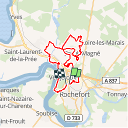
Tour Mountainbike von 33 km verfügbar auf Neu-Aquitanien, Charente-Maritime, Rochefort. Diese Tour wird von tracegps vorgeschlagen.
Beschreibung
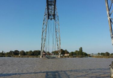
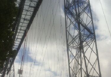
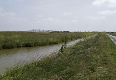
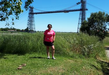
Parcours urbain pour le départ puis très vite on se trouve plongé au cœur des marais de Rochefort. (attention passage au travers d'un champ puis sur le haut d'un golf ouverts spécialement pour la rando => à éviter donc)
Ort
Land:
France
Region :
Neu-Aquitanien
Abteilung/Provinz :
Charente-Maritime
Kommune :
Rochefort
Standort:
Unknown
Gehen Sie:(Dec)
Gehen Sie:(UTM)
656795 ; 5090973 (30T) N.
Kommentare
Touren in der Umgebung
![Tour Wandern Rochefort - décathlon - Photo](https://media.geolcdn.com/t/375/260/ext.jpg?maxdim=2&url=https%3A%2F%2Fservices.sitytrail.com%2FGeolivesWS%2FDownloadMedia.ashx%3FTrailID%3D751971%26Media%3Dfix__20170513102135.jpg)
![Wandern Wandern](https://static1.geolcdn.com/sitytour/trail-icons/101.png)
décathlon
Wandern
Einfach
(1)
Rochefort,
Neu-Aquitanien,
Charente-Maritime,
France
![](/images/other/stat-length.png)
8,6 km | 9,2 km-effort
2h 3min
![](https://static1.geolcdn.com/siteimages/upload/files/16400158638029165_repeat_loop_refresh_sync_direction_icon.png)
Ja
![Tour Fahrrad Rochefort - Les ponts rochefortais - Rochefort - Photo](https://media.geolcdn.com/t/375/260/ext.jpg?maxdim=2&url=https%3A%2F%2Fservices.sitytrail.com%2FGeolivesWS%2FDownloadMedia.ashx%3FTrailID%3D172941%26Media%3D14418_2.jpg)
![Fahrrad Fahrrad](https://static1.geolcdn.com/sitytour/trail-icons/200.png)
Les ponts rochefortais - Rochefort
Fahrrad
Medium
(1)
Rochefort,
Neu-Aquitanien,
Charente-Maritime,
France
![](/images/other/stat-length.png)
28 km | 30 km-effort
3h 0min
![](https://static1.geolcdn.com/siteimages/upload/files/16400158638029165_repeat_loop_refresh_sync_direction_icon.png)
Ja
![Tour Hybrid-Bike Rochefort - Cyclo autour de Rochefort - Photo](https://media.geolcdn.com/t/375/260/2f277ad3-8f0a-493a-a624-0ba3c521f126.jpg&format=jpg&maxdim=2)
![Hybrid-Bike Hybrid-Bike](https://static1.geolcdn.com/sitytour/trail-icons/203.png)
Cyclo autour de Rochefort
Hybrid-Bike
Sehr leicht
Rochefort,
Neu-Aquitanien,
Charente-Maritime,
France
![](/images/other/stat-length.png)
66 km | 71 km-effort
4h 59min
![](https://static1.geolcdn.com/siteimages/upload/files/16400158638029165_repeat_loop_refresh_sync_direction_icon.png)
Ja
![Tour Hybrid-Bike Rochefort - Rochefort_ Breuil-Magné_Les Marais - Photo](https://media.geolcdn.com/t/375/260/ext.jpg?maxdim=2&url=https%3A%2F%2Fstatic1.geolcdn.com%2Fsiteimages%2Fupload%2Ffiles%2F1524743154velo.jpg)
![Hybrid-Bike Hybrid-Bike](https://static1.geolcdn.com/sitytour/trail-icons/203.png)
Rochefort_ Breuil-Magné_Les Marais
Hybrid-Bike
Einfach
(1)
Rochefort,
Neu-Aquitanien,
Charente-Maritime,
France
![](/images/other/stat-length.png)
38 km | 40 km-effort
3h 20min
![](https://static1.geolcdn.com/siteimages/upload/files/16400158638029165_repeat_loop_refresh_sync_direction_icon.png)
Ja
![Tour Wandern Rochefort - Rochefort - Photo](https://media.geolcdn.com/t/375/260/ext.jpg?maxdim=2&url=https%3A%2F%2Fservices.sitytrail.com%2FGeolivesWS%2FDownloadMedia.ashx%3FTrailID%3D476372%26Media%3Dfix__20150927173006.jpg)
![Wandern Wandern](https://static1.geolcdn.com/sitytour/trail-icons/101.png)
Rochefort
Wandern
Einfach
(1)
Rochefort,
Neu-Aquitanien,
Charente-Maritime,
France
![](/images/other/stat-length.png)
10,7 km | 11,7 km-effort
2h 53min
![](https://static1.geolcdn.com/siteimages/upload/files/16400158638029165_repeat_loop_refresh_sync_direction_icon.png)
Ja
![Tour Andere Aktivitäten Rochefort - Rochefort - pont transbordeur - Photo](https://media.geolcdn.com/t/375/260/ext.jpg?maxdim=2&url=https%3A%2F%2Fservices.sitytrail.com%2FGeolivesWS%2FDownloadMedia.ashx%3FTrailID%3D448908%26Media%3Dfix__20140428121407.jpg)
![Andere Aktivitäten Andere Aktivitäten](https://static1.geolcdn.com/sitytour/trail-icons/900.png)
Rochefort - pont transbordeur
Andere Aktivitäten
Sehr leicht
Rochefort,
Neu-Aquitanien,
Charente-Maritime,
France
![](/images/other/stat-length.png)
3,9 km | 4,2 km-effort
25min
![](https://static1.geolcdn.com/siteimages/upload/files/16400158638029165_repeat_loop_refresh_sync_direction_icon.png)
Nein
![Tour Wandern Rochefort - Rochefort - pont transbordeur - Photo](https://media.geolcdn.com/t/375/260/ext.jpg?maxdim=2&url=https%3A%2F%2Fservices.sitytrail.com%2FGeolivesWS%2FDownloadMedia.ashx%3FTrailID%3D271334%26Media%3Dfix__20140428121318.jpg)
![Wandern Wandern](https://static1.geolcdn.com/sitytour/trail-icons/101.png)
Rochefort - pont transbordeur
Wandern
Sehr leicht
Rochefort,
Neu-Aquitanien,
Charente-Maritime,
France
![](/images/other/stat-length.png)
3,9 km | 4,2 km-effort
25min
![](https://static1.geolcdn.com/siteimages/upload/files/16400158638029165_repeat_loop_refresh_sync_direction_icon.png)
Nein
![Tour Mountainbike Rochefort - 17-vtt-rochefort-tour-17km - Photo](https://media.geolcdn.com/t/375/260/a39986a4-605f-4c19-8e55-29dae387c299.jpg&format=jpg&maxdim=2)
![Mountainbike Mountainbike](https://static1.geolcdn.com/sitytour/trail-icons/202.png)
17-vtt-rochefort-tour-17km
Mountainbike
Einfach
Rochefort,
Neu-Aquitanien,
Charente-Maritime,
France
![](/images/other/stat-length.png)
16,8 km | 18 km-effort
2h 5min
![](https://static1.geolcdn.com/siteimages/upload/files/16400158638029165_repeat_loop_refresh_sync_direction_icon.png)
Ja
![Tour Mountainbike Rochefort - rochefort - st trojan - Photo](https://media.geolcdn.com/t/375/260/8230a513-be5b-45d2-bdc9-e111400f149e.jpg&format=jpg&maxdim=2)
![Mountainbike Mountainbike](https://static1.geolcdn.com/sitytour/trail-icons/202.png)
rochefort - st trojan
Mountainbike
Sehr leicht
Rochefort,
Neu-Aquitanien,
Charente-Maritime,
France
![](/images/other/stat-length.png)
51 km | 54 km-effort
4h 21min
![](https://static1.geolcdn.com/siteimages/upload/files/16400158638029165_repeat_loop_refresh_sync_direction_icon.png)
Nein