![](/images/other/stat-length.png)
![Tour Fahrrad Châteauneuf-sur-Charente - Circuit découverte (21B) - Châteauneuf-sur-Charente - Photo](https://media.geolcdn.com/t/1900/400/ext.pjpeg?maxdim=2&url=https%3A%2F%2Fservices.sitytrail.com%2FGeolivesWS%2FDownloadMedia.ashx%3FTrailID%3D106010%26Media%3D10127_6.jpg)
Circuit découverte (21B) - Châteauneuf-sur-Charente
tracegps
Benutzer
![Länge](/images/other/stat-length.png)
Länge
31 km
![Maximale Höhe](https://static1.geolcdn.com/siteimages/upload/files/1508320355ic_sort_altitude_max_24dp.png)
Maximale Höhe
100 m
![Positive Höhendifferenz](https://static1.geolcdn.com/siteimages/upload/files/1508320355ic_sort_den_pos_24dp.png)
Positive Höhendifferenz
354 m
![Km-Effort](/images/other/stat-length.png)
Km-Effort
36 km
![Min. Höhe](https://static1.geolcdn.com/siteimages/upload/files/1508320355ic_sort_altitude_min_24dp.png)
Min. Höhe
19 m
![Negative Höhendifferenz](https://static1.geolcdn.com/siteimages/upload/files/1508320355ic_sort_den_neg_24dp.png)
Negative Höhendifferenz
354 m
![Boucle](https://static1.geolcdn.com/siteimages/upload/files/16400158638029165_repeat_loop_refresh_sync_direction_icon.png)
Boucle
Ja
Erstellungsdatum :
2014-12-10 00:00:00.0
Letzte Änderung :
2014-12-10 00:00:00.0
![Fahrrad](https://static1.geolcdn.com/sitytour/trail-icons/200.png)
1h34
Schwierigkeit : Medium
![Scannen Sie diesen QR-Code, um die Tour in der SityTrail-Anwendung zu öffnen](https://capi.geolives.com/qq0zvz2zws4bq2lad0pu/sitytour/trails/106010/qr.png?size=200)
Kostenlosegpshiking-Anwendung
Über SityTrail
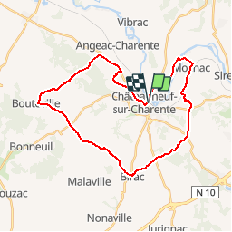
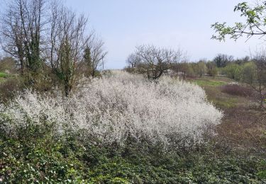
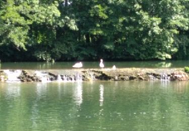
Tour Fahrrad von 31 km verfügbar auf Neu-Aquitanien, Charente, Châteauneuf-sur-Charente. Diese Tour wird von tracegps vorgeschlagen.
Beschreibung
Circuit proposé par Le Pays Ouest Charente et l’Office de Tourisme de Châteauneuf-sur-Charente, 2 rue du Général Leclerc. Départ de la place de la gare de Châteauneuf-sur-Charente. Retrouvez le plan du circuit sur le site du Conseil Général de Charente .
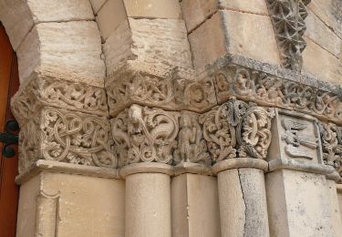
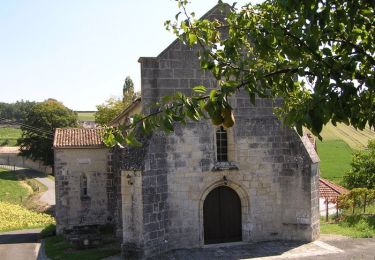
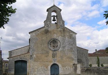
Ort
Land:
France
Region :
Neu-Aquitanien
Abteilung/Provinz :
Charente
Kommune :
Châteauneuf-sur-Charente
Standort:
Unknown
Gehen Sie:(Dec)
Gehen Sie:(UTM)
729992 ; 5053785 (30T) N.
Kommentare
Touren in der Umgebung
![Tour Zu Fuß Bellevigne - Chemin Boisné - Photo](https://media.geolcdn.com/t/375/260/4591f9b2-aa70-4c6e-b273-f78c9a53919a.jpeg&format=jpg&maxdim=2)
![Zu Fuß Zu Fuß](https://static1.geolcdn.com/sitytour/trail-icons/100.png)
Chemin Boisné
Zu Fuß
Einfach
Bellevigne,
Neu-Aquitanien,
Charente,
France
![](/images/other/stat-length.png)
15,6 km | 17 km-effort
3h 51min
![](https://static1.geolcdn.com/siteimages/upload/files/16400158638029165_repeat_loop_refresh_sync_direction_icon.png)
Nein
![Tour Fahrrad Châteauneuf-sur-Charente - Boucle exploration (21C) - Châteauneuf-sur-Charente - Photo](https://media.geolcdn.com/t/375/260/ext.jpg?maxdim=2&url=https%3A%2F%2Fservices.sitytrail.com%2FGeolivesWS%2FDownloadMedia.ashx%3FTrailID%3D106011%26Media%3D10128_6.jpg)
![Fahrrad Fahrrad](https://static1.geolcdn.com/sitytour/trail-icons/200.png)
Boucle exploration (21C) - Châteauneuf-sur-Charente
Fahrrad
Schwierig
Châteauneuf-sur-Charente,
Neu-Aquitanien,
Charente,
France
![](/images/other/stat-length.png)
42 km | 49 km-effort
2h 15min
![](https://static1.geolcdn.com/siteimages/upload/files/16400158638029165_repeat_loop_refresh_sync_direction_icon.png)
Ja
![Tour Fahrrad Châteauneuf-sur-Charente - Circuit famille en boucle (21A) - Châteauneuf-sur-Charente - Photo](https://media.geolcdn.com/t/375/260/ext.jpg?maxdim=2&url=https%3A%2F%2Fservices.sitytrail.com%2FGeolivesWS%2FDownloadMedia.ashx%3FTrailID%3D106009%26Media%3D10126_6.jpg)
![Fahrrad Fahrrad](https://static1.geolcdn.com/sitytour/trail-icons/200.png)
Circuit famille en boucle (21A) - Châteauneuf-sur-Charente
Fahrrad
Einfach
Châteauneuf-sur-Charente,
Neu-Aquitanien,
Charente,
France
![](/images/other/stat-length.png)
9,2 km | 10,2 km-effort
30min
![](https://static1.geolcdn.com/siteimages/upload/files/16400158638029165_repeat_loop_refresh_sync_direction_icon.png)
Ja
![Tour Andere Aktivitäten Mosnac-Saint-Simeux - 2011-07-14 17h18m12 - Photo](https://media.geolcdn.com/t/375/260/ext.jpg?maxdim=2&url=https%3A%2F%2Fstatic1.geolcdn.com%2Fsiteimages%2Fupload%2Ffiles%2F1545311037marcheuse_200dpi.jpg)
![Andere Aktivitäten Andere Aktivitäten](https://static1.geolcdn.com/sitytour/trail-icons/900.png)
2011-07-14 17h18m12
Andere Aktivitäten
Sehr leicht
(2)
Mosnac-Saint-Simeux,
Neu-Aquitanien,
Charente,
France
![](/images/other/stat-length.png)
10,4 km | 11,6 km-effort
Unbekannt
![](https://static1.geolcdn.com/siteimages/upload/files/16400158638029165_repeat_loop_refresh_sync_direction_icon.png)
Ja
![Tour Wandern - chamillon21036 - Photo](https://media.geolcdn.com/t/375/260/562fb04b-6aac-4831-a654-ec49e7a6d5d4.jpg&format=jpg&maxdim=2)
![Wandern Wandern](https://static1.geolcdn.com/sitytour/trail-icons/101.png)
![Tour Wandern Birac - Le quinze biracois 13-08-2016 - Photo](https://media.geolcdn.com/t/375/260/ext.jpg?maxdim=2&url=https%3A%2F%2Fstatic1.geolcdn.com%2Fsiteimages%2Fupload%2Ffiles%2F1553511878bg_sport_marche.png)
![Wandern Wandern](https://static1.geolcdn.com/sitytour/trail-icons/101.png)
Le quinze biracois 13-08-2016
Wandern
Medium
Birac,
Neu-Aquitanien,
Charente,
France
![](/images/other/stat-length.png)
15 km | 17,2 km-effort
3h 11min
![](https://static1.geolcdn.com/siteimages/upload/files/16400158638029165_repeat_loop_refresh_sync_direction_icon.png)
Ja
![Tour Wandern Graves-Saint-Amant - Graves St Amand 14-07-2016 - Photo](https://media.geolcdn.com/t/375/260/ext.jpg?maxdim=2&url=https%3A%2F%2Fservices.sitytrail.com%2FGeolivesWS%2FDownloadMedia.ashx%3FTrailID%3D597986%26Media%3Dfix__20160714113052.jpg)
![Wandern Wandern](https://static1.geolcdn.com/sitytour/trail-icons/101.png)
Graves St Amand 14-07-2016
Wandern
Einfach
Graves-Saint-Amant,
Neu-Aquitanien,
Charente,
France
![](/images/other/stat-length.png)
14,6 km | 16,6 km-effort
3h 17min
![](https://static1.geolcdn.com/siteimages/upload/files/16400158638029165_repeat_loop_refresh_sync_direction_icon.png)
Ja
![Tour Wandern Mosnac-Saint-Simeux - saint simeux 1 - Photo](https://media.geolcdn.com/t/375/260/ext.jpg?maxdim=2&url=https%3A%2F%2Fstatic1.geolcdn.com%2Fsiteimages%2Fupload%2Ffiles%2F1553511878bg_sport_marche.png)
![Wandern Wandern](https://static1.geolcdn.com/sitytour/trail-icons/101.png)
saint simeux 1
Wandern
Einfach
Mosnac-Saint-Simeux,
Neu-Aquitanien,
Charente,
France
![](/images/other/stat-length.png)
6,1 km | 7,1 km-effort
1h 21min
![](https://static1.geolcdn.com/siteimages/upload/files/16400158638029165_repeat_loop_refresh_sync_direction_icon.png)
Ja
![Tour Wandern - Champmillon - Photo](https://media.geolcdn.com/t/375/260/ext.jpg?maxdim=2&url=https%3A%2F%2Fstatic1.geolcdn.com%2Fsiteimages%2Fupload%2Ffiles%2F1553511878bg_sport_marche.png)
![Wandern Wandern](https://static1.geolcdn.com/sitytour/trail-icons/101.png)