![](/images/other/stat-length.png)
![Tour Wandern Plouégat-Guérand - Sent Douron - Plouégat-Guérand - Photo](https://media.geolcdn.com/t/1900/400/ext.pjpeg?maxdim=2&url=https%3A%2F%2Fservices.sitytrail.com%2FGeolivesWS%2FDownloadMedia.ashx%3FTrailID%3D105899%26Media%3D9894_2.jpg)
Sent Douron - Plouégat-Guérand
tracegps
Benutzer
![Länge](/images/other/stat-length.png)
Länge
13,2 km
![Maximale Höhe](https://static1.geolcdn.com/siteimages/upload/files/1508320355ic_sort_altitude_max_24dp.png)
Maximale Höhe
140 m
![Positive Höhendifferenz](https://static1.geolcdn.com/siteimages/upload/files/1508320355ic_sort_den_pos_24dp.png)
Positive Höhendifferenz
189 m
![Km-Effort](/images/other/stat-length.png)
Km-Effort
15,7 km
![Min. Höhe](https://static1.geolcdn.com/siteimages/upload/files/1508320355ic_sort_altitude_min_24dp.png)
Min. Höhe
32 m
![Negative Höhendifferenz](https://static1.geolcdn.com/siteimages/upload/files/1508320355ic_sort_den_neg_24dp.png)
Negative Höhendifferenz
188 m
![Boucle](https://static1.geolcdn.com/siteimages/upload/files/16400158638029165_repeat_loop_refresh_sync_direction_icon.png)
Boucle
Ja
Erstellungsdatum :
2014-12-10 00:00:00.0
Letzte Änderung :
2014-12-10 00:00:00.0
![Wandern](https://static1.geolcdn.com/sitytour/trail-icons/101.png)
3h19
Schwierigkeit : Schwierig
![Scannen Sie diesen QR-Code, um die Tour in der SityTrail-Anwendung zu öffnen](https://capi.geolives.com/qq0zvz2zws4bq2lad0pu/sitytour/trails/105899/qr.png?size=200)
Kostenlosegpshiking-Anwendung
Über SityTrail
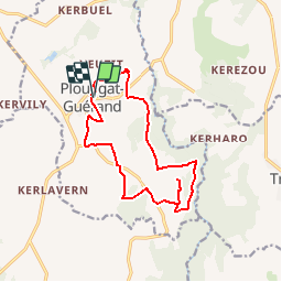
Tour Wandern von 13,2 km verfügbar auf Bretagne, Finistère, Plouégat-Guérand. Diese Tour wird von tracegps vorgeschlagen.
Beschreibung
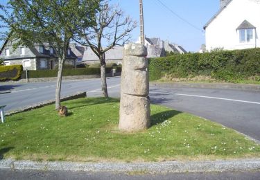
Circuit proposé par l'Association Henchou Don Lanvaeleg. Départ de l’église de Plouégat-Guérand. Au pays des cerisiers, balade en sous bois dans le Trégor Finistérien.
Ort
Land:
France
Region :
Bretagne
Abteilung/Provinz :
Finistère
Kommune :
Plouégat-Guérand
Standort:
Unknown
Gehen Sie:(Dec)
Gehen Sie:(UTM)
450359 ; 5385495 (30U) N.
Kommentare
Touren in der Umgebung
![Tour Mountainbike Plestin-les-Grèves - Circuit des chapelles, coté terre - Plestin-les-Grèves - Photo](https://media.geolcdn.com/t/375/260/ext.jpg?maxdim=2&url=https%3A%2F%2Fservices.sitytrail.com%2FGeolivesWS%2FDownloadMedia.ashx%3FTrailID%3D105558%26Media%3D9320_2.jpg)
![Mountainbike Mountainbike](https://static1.geolcdn.com/sitytour/trail-icons/202.png)
Circuit des chapelles, coté terre - Plestin-les-Grèves
Mountainbike
Medium
(1)
Plestin-les-Grèves,
Bretagne,
Côtes-d'Armor,
France
![](/images/other/stat-length.png)
17,1 km | 20 km-effort
2h 0min
![](https://static1.geolcdn.com/siteimages/upload/files/16400158638029165_repeat_loop_refresh_sync_direction_icon.png)
Ja
![Tour Wandern Plestin-les-Grèves - Circuit de la chapelle Sainte Anne - Plestin-les-Grèves - Photo](https://media.geolcdn.com/t/375/260/ext.jpg?maxdim=2&url=https%3A%2F%2Fservices.sitytrail.com%2FGeolivesWS%2FDownloadMedia.ashx%3FTrailID%3D112066%26Media%3D9659_3.jpg)
![Wandern Wandern](https://static1.geolcdn.com/sitytour/trail-icons/101.png)
Circuit de la chapelle Sainte Anne - Plestin-les-Grèves
Wandern
Einfach
Plestin-les-Grèves,
Bretagne,
Côtes-d'Armor,
France
![](/images/other/stat-length.png)
6,9 km | 8,4 km-effort
1h 40min
![](https://static1.geolcdn.com/siteimages/upload/files/16400158638029165_repeat_loop_refresh_sync_direction_icon.png)
Ja
![Tour Wandern Plestin-les-Grèves - Circuit de la chapelle St Jagut - Plestin-les-Grèves - Photo](https://media.geolcdn.com/t/375/260/ext.jpg?maxdim=2&url=https%3A%2F%2Fservices.sitytrail.com%2FGeolivesWS%2FDownloadMedia.ashx%3FTrailID%3D112002%26Media%3D9420_3.jpg)
![Wandern Wandern](https://static1.geolcdn.com/sitytour/trail-icons/101.png)
Circuit de la chapelle St Jagut - Plestin-les-Grèves
Wandern
Einfach
Plestin-les-Grèves,
Bretagne,
Côtes-d'Armor,
France
![](/images/other/stat-length.png)
7,9 km | 9,2 km-effort
2h 0min
![](https://static1.geolcdn.com/siteimages/upload/files/16400158638029165_repeat_loop_refresh_sync_direction_icon.png)
Ja
![Tour Mountainbike Plestin-les-Grèves - Circuit des chapelles, coté mer - Plestin-les-Grèves - Photo](https://media.geolcdn.com/t/375/260/ext.jpg?maxdim=2&url=https%3A%2F%2Fservices.sitytrail.com%2FGeolivesWS%2FDownloadMedia.ashx%3FTrailID%3D105557%26Media%3D9319_6.jpg)
![Mountainbike Mountainbike](https://static1.geolcdn.com/sitytour/trail-icons/202.png)
Circuit des chapelles, coté mer - Plestin-les-Grèves
Mountainbike
Einfach
Plestin-les-Grèves,
Bretagne,
Côtes-d'Armor,
France
![](/images/other/stat-length.png)
9,6 km | 11,2 km-effort
1h 0min
![](https://static1.geolcdn.com/siteimages/upload/files/16400158638029165_repeat_loop_refresh_sync_direction_icon.png)
Ja
![Tour Zu Fuß Plestin-les-Grèves - GR 34 B - Photo](https://media.geolcdn.com/t/375/260/ext.jpg?maxdim=2&url=https%3A%2F%2Fmedia.geolcdn.com%2Ff%2Fe7fc9aa2-b731-4eb4-a999-de9ae692dd4a.jpeg)
![Zu Fuß Zu Fuß](https://static1.geolcdn.com/sitytour/trail-icons/100.png)
GR 34 B
Zu Fuß
Einfach
Plestin-les-Grèves,
Bretagne,
Côtes-d'Armor,
France
![](/images/other/stat-length.png)
3,6 km | 4,2 km-effort
57min
![](https://static1.geolcdn.com/siteimages/upload/files/16400158638029165_repeat_loop_refresh_sync_direction_icon.png)
Nein
![Tour Wandern Plestin-les-Grèves - Circuit de la chapelle St Roch - Plestin-les-Grèves - Photo](https://media.geolcdn.com/t/375/260/ext.jpg?maxdim=2&url=https%3A%2F%2Fservices.sitytrail.com%2FGeolivesWS%2FDownloadMedia.ashx%3FTrailID%3D112003%26Media%3D9421_2.jpg)
![Wandern Wandern](https://static1.geolcdn.com/sitytour/trail-icons/101.png)
Circuit de la chapelle St Roch - Plestin-les-Grèves
Wandern
Einfach
Plestin-les-Grèves,
Bretagne,
Côtes-d'Armor,
France
![](/images/other/stat-length.png)
5,8 km | 7,2 km-effort
1h 30min
![](https://static1.geolcdn.com/siteimages/upload/files/16400158638029165_repeat_loop_refresh_sync_direction_icon.png)
Ja
![Tour Wandern Plouégat-Guérand - Plouegat Guerrand - Photo](https://media.geolcdn.com/t/375/260/ext.jpg?maxdim=2&url=https%3A%2F%2Fstatic1.geolcdn.com%2Fsiteimages%2Fupload%2Ffiles%2F1553511878bg_sport_marche.png)
![Wandern Wandern](https://static1.geolcdn.com/sitytour/trail-icons/101.png)
Plouegat Guerrand
Wandern
Schwierig
Plouégat-Guérand,
Bretagne,
Finistère,
France
![](/images/other/stat-length.png)
10,4 km | 12,5 km-effort
2h 52min
![](https://static1.geolcdn.com/siteimages/upload/files/16400158638029165_repeat_loop_refresh_sync_direction_icon.png)
Ja
![Tour Andere Aktivitäten Plestin-les-Grèves - Douron - Photo](https://media.geolcdn.com/t/375/260/ext.jpg?maxdim=2&url=https%3A%2F%2Fstatic1.geolcdn.com%2Fsiteimages%2Fupload%2Ffiles%2F1545311037marcheuse_200dpi.jpg)
![Andere Aktivitäten Andere Aktivitäten](https://static1.geolcdn.com/sitytour/trail-icons/900.png)
Douron
Andere Aktivitäten
Sehr leicht
Plestin-les-Grèves,
Bretagne,
Côtes-d'Armor,
France
![](/images/other/stat-length.png)
12,6 km | 14,8 km-effort
4h 40min
![](https://static1.geolcdn.com/siteimages/upload/files/16400158638029165_repeat_loop_refresh_sync_direction_icon.png)
Ja
![Tour Wandern Lanmeur - Le petit train - Photo](https://media.geolcdn.com/t/375/260/ext.jpg?maxdim=2&url=https%3A%2F%2Fstatic1.geolcdn.com%2Fsiteimages%2Fupload%2Ffiles%2F1553511878bg_sport_marche.png)
![Wandern Wandern](https://static1.geolcdn.com/sitytour/trail-icons/101.png)
Le petit train
Wandern
Einfach
Lanmeur,
Bretagne,
Finistère,
France
![](/images/other/stat-length.png)
9,3 km | 10,4 km-effort
2h 17min
![](https://static1.geolcdn.com/siteimages/upload/files/16400158638029165_repeat_loop_refresh_sync_direction_icon.png)
Ja
bouclé de St-Mars ch. à Lonperrier