![](/images/other/stat-length.png)
![Tour Wandern Plougras - Eoliennes et étang de Beffou - Plougras - Photo](https://media.geolcdn.com/t/1900/400/ext.pjpeg?maxdim=2&url=https%3A%2F%2Fservices.sitytrail.com%2FGeolivesWS%2FDownloadMedia.ashx%3FTrailID%3D105822%26Media%3D9760_4.jpg)
Eoliennes et étang de Beffou - Plougras
tracegps
Benutzer
![Länge](/images/other/stat-length.png)
Länge
9,3 km
![Maximale Höhe](https://static1.geolcdn.com/siteimages/upload/files/1508320355ic_sort_altitude_max_24dp.png)
Maximale Höhe
313 m
![Positive Höhendifferenz](https://static1.geolcdn.com/siteimages/upload/files/1508320355ic_sort_den_pos_24dp.png)
Positive Höhendifferenz
133 m
![Km-Effort](/images/other/stat-length.png)
Km-Effort
11 km
![Min. Höhe](https://static1.geolcdn.com/siteimages/upload/files/1508320355ic_sort_altitude_min_24dp.png)
Min. Höhe
202 m
![Negative Höhendifferenz](https://static1.geolcdn.com/siteimages/upload/files/1508320355ic_sort_den_neg_24dp.png)
Negative Höhendifferenz
133 m
![Boucle](https://static1.geolcdn.com/siteimages/upload/files/16400158638029165_repeat_loop_refresh_sync_direction_icon.png)
Boucle
Ja
Erstellungsdatum :
2014-12-10 00:00:00.0
Letzte Änderung :
2014-12-10 00:00:00.0
![Wandern](https://static1.geolcdn.com/sitytour/trail-icons/101.png)
2h19
Schwierigkeit : Medium
![Scannen Sie diesen QR-Code, um die Tour in der SityTrail-Anwendung zu öffnen](https://capi.geolives.com/qq0zvz2zws4bq2lad0pu/sitytour/trails/105822/qr.png?size=200)
Kostenlosegpshiking-Anwendung
Über SityTrail
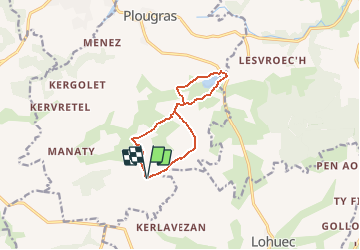
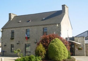
Tour Wandern von 9,3 km verfügbar auf Bretagne, Côtes-d'Armor, Plougras. Diese Tour wird von tracegps vorgeschlagen.
Beschreibung
Circuit proposé par l’association Henchou Don Lanvaeleg . Départ du pied des éoliennes, il est également possible de partir de l’étang de Beffou, mais les possibilités de stationnement sont limitées.
Ort
Land:
France
Region :
Bretagne
Abteilung/Provinz :
Côtes-d'Armor
Kommune :
Plougras
Standort:
Unknown
Gehen Sie:(Dec)
Gehen Sie:(UTM)
458326 ; 5369143 (30U) N.
Kommentare
Touren in der Umgebung
![Tour Wandern Plougras - Autour de Plougras, abord de Guerlesquin - Photo](https://media.geolcdn.com/t/375/260/a8b09fd5-9992-462e-8ed5-e1e4f5c9f890.jpg&format=jpg&maxdim=2)
![Wandern Wandern](https://static1.geolcdn.com/sitytour/trail-icons/101.png)
Autour de Plougras, abord de Guerlesquin
Wandern
Einfach
Plougras,
Bretagne,
Côtes-d'Armor,
France
![](/images/other/stat-length.png)
8,7 km | 10,4 km-effort
2h 5min
![](https://static1.geolcdn.com/siteimages/upload/files/16400158638029165_repeat_loop_refresh_sync_direction_icon.png)
Ja
![Tour Zu Fuß Guerlesquin - L'Étang du Guic - Photo](https://media.geolcdn.com/t/375/260/e37d09e2-5e71-44c7-8599-762e549e8bd0.jpeg&format=jpg&maxdim=2)
![Zu Fuß Zu Fuß](https://static1.geolcdn.com/sitytour/trail-icons/100.png)
L'Étang du Guic
Zu Fuß
Medium
Guerlesquin,
Bretagne,
Finistère,
France
![](/images/other/stat-length.png)
15,9 km | 20 km-effort
4h 33min
![](https://static1.geolcdn.com/siteimages/upload/files/16400158638029165_repeat_loop_refresh_sync_direction_icon.png)
Ja
![Tour Zu Fuß Botsorhel - Botshorel Morlaix - Photo](https://media.geolcdn.com/t/375/260/ext.jpg?maxdim=2&url=https%3A%2F%2Fstatic1.geolcdn.com%2Fsiteimages%2Fupload%2Ffiles%2F1545311037marcheuse_200dpi.jpg)
![Zu Fuß Zu Fuß](https://static1.geolcdn.com/sitytour/trail-icons/100.png)
Botshorel Morlaix
Zu Fuß
Schwierig
Botsorhel,
Bretagne,
Finistère,
France
![](/images/other/stat-length.png)
29 km | 35 km-effort
8h 3min
![](https://static1.geolcdn.com/siteimages/upload/files/16400158638029165_repeat_loop_refresh_sync_direction_icon.png)
Nein
![Tour Zu Fuß Botsorhel - 2022-04-02_21h02m45_SityTrail - 3150665 - et5xbotsorhelxmorlaix - Photo](https://media.geolcdn.com/t/375/260/ext.jpg?maxdim=2&url=https%3A%2F%2Fstatic1.geolcdn.com%2Fsiteimages%2Fupload%2Ffiles%2F1545311037marcheuse_200dpi.jpg)
![Zu Fuß Zu Fuß](https://static1.geolcdn.com/sitytour/trail-icons/100.png)
2022-04-02_21h02m45_SityTrail - 3150665 - et5xbotsorhelxmorlaix
Zu Fuß
Schwierig
Botsorhel,
Bretagne,
Finistère,
France
![](/images/other/stat-length.png)
30 km | 36 km-effort
8h 10min
![](https://static1.geolcdn.com/siteimages/upload/files/16400158638029165_repeat_loop_refresh_sync_direction_icon.png)
Nein
![Tour Wandern Plougras - Tro ar Guic - Plougras - Photo](https://media.geolcdn.com/t/375/260/ext.jpg?maxdim=2&url=https%3A%2F%2Fservices.sitytrail.com%2FGeolivesWS%2FDownloadMedia.ashx%3FTrailID%3D105909%26Media%3D9927_2.jpg)
![Wandern Wandern](https://static1.geolcdn.com/sitytour/trail-icons/101.png)
Tro ar Guic - Plougras
Wandern
Medium
(1)
Plougras,
Bretagne,
Côtes-d'Armor,
France
![](/images/other/stat-length.png)
8,1 km | 9,7 km-effort
2h 0min
![](https://static1.geolcdn.com/siteimages/upload/files/16400158638029165_repeat_loop_refresh_sync_direction_icon.png)
Ja
![Tour Wandern Plougras - Autour de l''étang du Guic - Guerlesquin - Photo](https://media.geolcdn.com/t/375/260/ext.jpg?maxdim=2&url=https%3A%2F%2Fservices.sitytrail.com%2FGeolivesWS%2FDownloadMedia.ashx%3FTrailID%3D215270%26Media%3D15562_1.jpg)
![Wandern Wandern](https://static1.geolcdn.com/sitytour/trail-icons/101.png)
Autour de l''étang du Guic - Guerlesquin
Wandern
Medium
Plougras,
Bretagne,
Côtes-d'Armor,
France
![](/images/other/stat-length.png)
2,8 km | 3,3 km-effort
45min
![](https://static1.geolcdn.com/siteimages/upload/files/16400158638029165_repeat_loop_refresh_sync_direction_icon.png)
Ja
![Tour Wandern Guerlesquin - De Guerlesquin à la forêt de Beffou - Photo](https://media.geolcdn.com/t/375/260/ext.jpg?maxdim=2&url=https%3A%2F%2Fstatic1.geolcdn.com%2Fsiteimages%2Fupload%2Ffiles%2F1553511878bg_sport_marche.png)
![Wandern Wandern](https://static1.geolcdn.com/sitytour/trail-icons/101.png)
De Guerlesquin à la forêt de Beffou
Wandern
Sehr schwierig
Guerlesquin,
Bretagne,
Finistère,
France
![](/images/other/stat-length.png)
36 km | 44 km-effort
8h 0min
![](https://static1.geolcdn.com/siteimages/upload/files/16400158638029165_repeat_loop_refresh_sync_direction_icon.png)
Ja
![Tour Wandern Guerlesquin - Autour de Guerlesquin et l'étang du Guic - Photo](https://media.geolcdn.com/t/375/260/ext.jpg?maxdim=2&url=https%3A%2F%2Fstatic1.geolcdn.com%2Fsiteimages%2Fupload%2Ffiles%2F1553511878bg_sport_marche.png)
![Wandern Wandern](https://static1.geolcdn.com/sitytour/trail-icons/101.png)
Autour de Guerlesquin et l'étang du Guic
Wandern
Schwierig
Guerlesquin,
Bretagne,
Finistère,
France
![](/images/other/stat-length.png)
22 km | 28 km-effort
4h 45min
![](https://static1.geolcdn.com/siteimages/upload/files/16400158638029165_repeat_loop_refresh_sync_direction_icon.png)
Ja
![Tour Wandern Guerlesquin - 29_guerlesquin_sud_ouest - Photo](https://media.geolcdn.com/t/375/260/ext.jpg?maxdim=2&url=https%3A%2F%2Fstatic1.geolcdn.com%2Fsiteimages%2Fupload%2Ffiles%2F1553511878bg_sport_marche.png)
![Wandern Wandern](https://static1.geolcdn.com/sitytour/trail-icons/101.png)
29_guerlesquin_sud_ouest
Wandern
Medium
Guerlesquin,
Bretagne,
Finistère,
France
![](/images/other/stat-length.png)
10,8 km | 13 km-effort
2h 27min
![](https://static1.geolcdn.com/siteimages/upload/files/16400158638029165_repeat_loop_refresh_sync_direction_icon.png)
Ja