![](/images/other/stat-length.png)
![Tour Mountainbike Cailleville - Veules les Roses - Photo](https://media.geolcdn.com/t/1900/400/ext.pjpeg?maxdim=2&url=https%3A%2F%2Fservices.sitytrail.com%2FGeolivesWS%2FDownloadMedia.ashx%3FTrailID%3D105617%26Media%3D9386_1.jpg)
Veules les Roses
tracegps
Benutzer
![Länge](/images/other/stat-length.png)
Länge
38 km
![Maximale Höhe](https://static1.geolcdn.com/siteimages/upload/files/1508320355ic_sort_altitude_max_24dp.png)
Maximale Höhe
86 m
![Positive Höhendifferenz](https://static1.geolcdn.com/siteimages/upload/files/1508320355ic_sort_den_pos_24dp.png)
Positive Höhendifferenz
422 m
![Km-Effort](/images/other/stat-length.png)
Km-Effort
43 km
![Min. Höhe](https://static1.geolcdn.com/siteimages/upload/files/1508320355ic_sort_altitude_min_24dp.png)
Min. Höhe
0 m
![Negative Höhendifferenz](https://static1.geolcdn.com/siteimages/upload/files/1508320355ic_sort_den_neg_24dp.png)
Negative Höhendifferenz
407 m
![Boucle](https://static1.geolcdn.com/siteimages/upload/files/16400158638029165_repeat_loop_refresh_sync_direction_icon.png)
Boucle
Ja
Erstellungsdatum :
2014-12-10 00:00:00.0
Letzte Änderung :
2014-12-10 00:00:00.0
![Mountainbike](https://static1.geolcdn.com/sitytour/trail-icons/202.png)
2h30
Schwierigkeit : Medium
![Scannen Sie diesen QR-Code, um die Tour in der SityTrail-Anwendung zu öffnen](https://capi.geolives.com/qq0zvz2zws4bq2lad0pu/sitytour/trails/105617/qr.png?size=200)
Kostenlosegpshiking-Anwendung
Über SityTrail
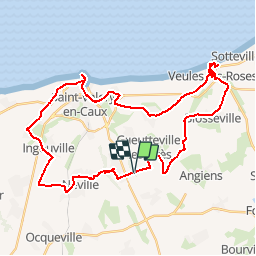
Tour Mountainbike von 38 km verfügbar auf Normandie, Seine-Maritime, Cailleville. Diese Tour wird von tracegps vorgeschlagen.
Beschreibung
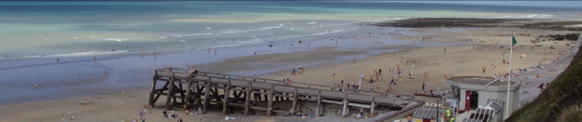
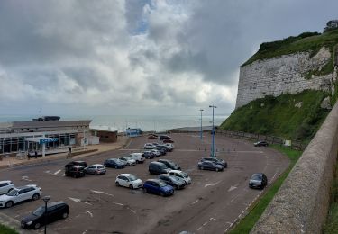
Parcours permettant de découvrir le Pays de Caux et les falaises de Veules et de Saint Valéry en Caux.
Ort
Land:
France
Region :
Normandie
Abteilung/Provinz :
Seine-Maritime
Kommune :
Cailleville
Standort:
Unknown
Gehen Sie:(Dec)
Gehen Sie:(UTM)
337844 ; 5522013 (31U) N.
Kommentare
Touren in der Umgebung
![Tour Rennrad Saint-Valery-en-Caux - Sainte Marie La Flotte retour - Photo](https://media.geolcdn.com/t/375/260/c953ac11-fd11-47b9-9f84-6149c27e4f08.jpg&format=jpg&maxdim=2)
![Rennrad Rennrad](https://static1.geolcdn.com/sitytour/trail-icons/201.png)
Sainte Marie La Flotte retour
Rennrad
Einfach
Saint-Valery-en-Caux,
Normandie,
Seine-Maritime,
France
![](/images/other/stat-length.png)
554 km | 638 km-effort
2h 38min
![](https://static1.geolcdn.com/siteimages/upload/files/16400158638029165_repeat_loop_refresh_sync_direction_icon.png)
Nein
![Tour Rennrad Ocqueville - Les grandes dalles - Photo](https://media.geolcdn.com/t/375/260/ef7ef045-acb3-4d2f-85c0-a2e87799d551.jpg&format=jpg&maxdim=2)
![Rennrad Rennrad](https://static1.geolcdn.com/sitytour/trail-icons/201.png)
Les grandes dalles
Rennrad
Medium
Ocqueville,
Normandie,
Seine-Maritime,
France
![](/images/other/stat-length.png)
63 km | 70 km-effort
4h 16min
![](https://static1.geolcdn.com/siteimages/upload/files/16400158638029165_repeat_loop_refresh_sync_direction_icon.png)
Ja
![Tour Wandern Saint-Valery-en-Caux - boucle de st valery en cause à veules et retour par la plage - Photo](https://media.geolcdn.com/t/375/260/1b47ad71-45e2-413b-af01-56a4ea59949a.jpg&format=jpg&maxdim=2)
![Wandern Wandern](https://static1.geolcdn.com/sitytour/trail-icons/101.png)
boucle de st valery en cause à veules et retour par la plage
Wandern
Sehr schwierig
Saint-Valery-en-Caux,
Normandie,
Seine-Maritime,
France
![](/images/other/stat-length.png)
18,4 km | 21 km-effort
4h 40min
![](https://static1.geolcdn.com/siteimages/upload/files/16400158638029165_repeat_loop_refresh_sync_direction_icon.png)
Nein
![Tour Wandern Ermenouville - Ermenouvillle - Le Mesnil Geoffroy - Photo](https://media.geolcdn.com/t/375/260/5bb1fe76-5828-4c00-8543-c120e4c71a2a.jpg&format=jpg&maxdim=2)
![Wandern Wandern](https://static1.geolcdn.com/sitytour/trail-icons/101.png)
Ermenouvillle - Le Mesnil Geoffroy
Wandern
Sehr leicht
Ermenouville,
Normandie,
Seine-Maritime,
France
![](/images/other/stat-length.png)
15,3 km | 17,2 km-effort
5h 26min
![](https://static1.geolcdn.com/siteimages/upload/files/16400158638029165_repeat_loop_refresh_sync_direction_icon.png)
Ja
![Tour Wandern Ermenouville - Ermenouville . Château de Mesnil-Geoffroy - Photo](https://media.geolcdn.com/t/375/260/7a0d7ca8-1cee-4dbe-ad74-2fd526e4e0b8.jpg&format=jpg&maxdim=2)
![Wandern Wandern](https://static1.geolcdn.com/sitytour/trail-icons/101.png)
Ermenouville . Château de Mesnil-Geoffroy
Wandern
Sehr leicht
Ermenouville,
Normandie,
Seine-Maritime,
France
![](/images/other/stat-length.png)
13,4 km | 0 m-effort
3h 56min
![](https://static1.geolcdn.com/siteimages/upload/files/16400158638029165_repeat_loop_refresh_sync_direction_icon.png)
Nein
![Tour Andere Aktivitäten Drosay - Le bois des Saules - Drosay - Photo](https://media.geolcdn.com/t/375/260/ext.jpg?maxdim=2&url=https%3A%2F%2Fservices.sitytrail.com%2FGeolivesWS%2FDownloadMedia.ashx%3FTrailID%3D317715%26Media%3D17026_5.jpg)
![Andere Aktivitäten Andere Aktivitäten](https://static1.geolcdn.com/sitytour/trail-icons/900.png)
Le bois des Saules - Drosay
Andere Aktivitäten
Medium
Drosay,
Normandie,
Seine-Maritime,
France
![](/images/other/stat-length.png)
12,1 km | 13,4 km-effort
2h 15min
![](https://static1.geolcdn.com/siteimages/upload/files/16400158638029165_repeat_loop_refresh_sync_direction_icon.png)
Ja
![Tour Laufen Drosay - Le bois des Saules - Drosay - Photo](https://media.geolcdn.com/t/375/260/ext.jpg?maxdim=2&url=https%3A%2F%2Fservices.sitytrail.com%2FGeolivesWS%2FDownloadMedia.ashx%3FTrailID%3D317714%26Media%3D17026_5.jpg)
![Laufen Laufen](https://static1.geolcdn.com/sitytour/trail-icons/103.png)
Le bois des Saules - Drosay
Laufen
Schwierig
Drosay,
Normandie,
Seine-Maritime,
France
![](/images/other/stat-length.png)
12,1 km | 13,4 km-effort
1h 30min
![](https://static1.geolcdn.com/siteimages/upload/files/16400158638029165_repeat_loop_refresh_sync_direction_icon.png)
Ja
![Tour Wandern Drosay - Le bois des Saules - Drosay - Photo](https://media.geolcdn.com/t/375/260/ext.jpg?maxdim=2&url=https%3A%2F%2Fservices.sitytrail.com%2FGeolivesWS%2FDownloadMedia.ashx%3FTrailID%3D317713%26Media%3D17026_5.jpg)
![Wandern Wandern](https://static1.geolcdn.com/sitytour/trail-icons/101.png)
Le bois des Saules - Drosay
Wandern
Medium
Drosay,
Normandie,
Seine-Maritime,
France
![](/images/other/stat-length.png)
12,1 km | 13,4 km-effort
2h 30min
![](https://static1.geolcdn.com/siteimages/upload/files/16400158638029165_repeat_loop_refresh_sync_direction_icon.png)
Ja
![Tour Andere Aktivitäten Le Mesnil-Durdent - Les Amouhoques - Le Mesmil-Durdent - Photo](https://media.geolcdn.com/t/375/260/ext.jpg?maxdim=2&url=https%3A%2F%2Fservices.sitytrail.com%2FGeolivesWS%2FDownloadMedia.ashx%3FTrailID%3D317494%26Media%3D16728_5.jpg)
![Andere Aktivitäten Andere Aktivitäten](https://static1.geolcdn.com/sitytour/trail-icons/900.png)
Les Amouhoques - Le Mesmil-Durdent
Andere Aktivitäten
Schwierig
Le Mesnil-Durdent,
Normandie,
Seine-Maritime,
France
![](/images/other/stat-length.png)
18,9 km | 22 km-effort
2h 0min
![](https://static1.geolcdn.com/siteimages/upload/files/16400158638029165_repeat_loop_refresh_sync_direction_icon.png)
Ja