![](/images/other/stat-length.png)
![Tour Mountainbike Bergholz - Espace VTT - FFC Région de Guebwiller - n°17 - Circuit du Bollenberg - Photo](https://media.geolcdn.com/t/1900/400/ext.pjpeg?maxdim=2&url=https%3A%2F%2Fservices.sitytrail.com%2FGeolivesWS%2FDownloadMedia.ashx%3FTrailID%3D105539%26Media%3D9305_1.jpg)
Espace VTT - FFC Région de Guebwiller - n°17 - Circuit du Bollenberg
tracegps
Benutzer
![Länge](/images/other/stat-length.png)
![Maximale Höhe](https://static1.geolcdn.com/siteimages/upload/files/1508320355ic_sort_altitude_max_24dp.png)
![Positive Höhendifferenz](https://static1.geolcdn.com/siteimages/upload/files/1508320355ic_sort_den_pos_24dp.png)
![Km-Effort](/images/other/stat-length.png)
![Min. Höhe](https://static1.geolcdn.com/siteimages/upload/files/1508320355ic_sort_altitude_min_24dp.png)
![Negative Höhendifferenz](https://static1.geolcdn.com/siteimages/upload/files/1508320355ic_sort_den_neg_24dp.png)
![Boucle](https://static1.geolcdn.com/siteimages/upload/files/16400158638029165_repeat_loop_refresh_sync_direction_icon.png)
![Mountainbike](https://static1.geolcdn.com/sitytour/trail-icons/202.png)
40m
Schwierigkeit : Einfach
![Scannen Sie diesen QR-Code, um die Tour in der SityTrail-Anwendung zu öffnen](https://capi.geolives.com/qq0zvz2zws4bq2lad0pu/sitytour/trails/105539/qr.png?size=200)
Kostenlosegpshiking-Anwendung
Über SityTrail
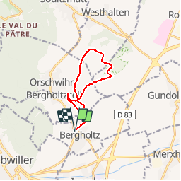
Tour Mountainbike von 9,2 km verfügbar auf Großer Osten, Oberelsass, Bergholz. Diese Tour wird von tracegps vorgeschlagen.
Beschreibung
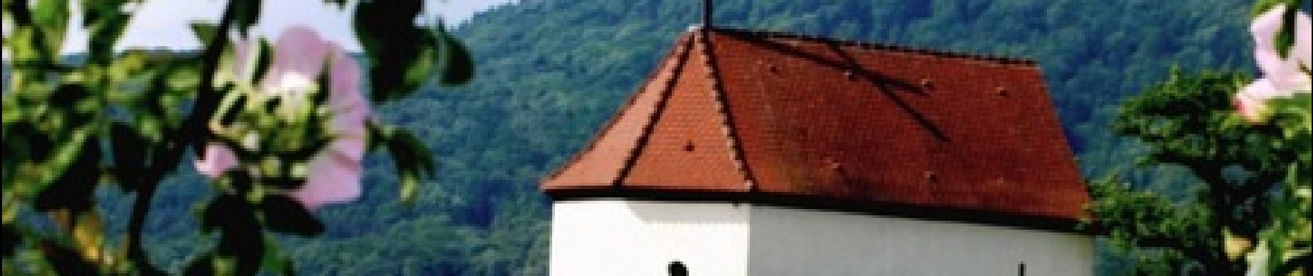
Espace VTT - FFC Région de Guebwiller - n°17 - Circuit du Bollenberg Circuit officiel labellisé par la Fédération Française de Cyclisme. Ce tracé familial, entièrement fléché dans le vignoble, comporte d’innombrables points de vue dont celui de la chapelle du Bollenberg, appelée aussi chapelle des Sorcières. La présence de sarcophages découverts à proximité de l’ancienne église atteste de l’existence de Bergholtz dès le Moyen-Âge. De par son appartenance à l’abbaye de Murbach (XIIème siècle), Bergholtz et Bergholtz-Zell ne forment qu’une seule communauté. Elles se sépareront en 1827. Les carrières de Bergholtz et Bergholtz-Zell fourniront les pierres de taille nécessaires à la construction de la forteresse de Neuf-Brisach (Vauban 1699) par le biais du canal Vauban. Topo guide VTT en vente à l’Office du Tourisme de Guebwiller-Soultz et les Pays du Florival - Antenne de Guebwiller - 71 Rue de la République - 68500 – Guebwiller Tel. : 03 89 76 10 63 - Fax :03 89 76 52 72 Crédit photos ; ©Pays d’Art et d’Histoire de la Région de Guebwiller
Ort
Kommentare
Touren in der Umgebung
![Tour Wandern Westhalten - 2021 03 04 Westhalten - Photo](https://media.geolcdn.com/t/375/260/227de508-d68e-430e-b1c3-67de94c52b45.jpg&format=jpg&maxdim=2)
![Wandern Wandern](https://static1.geolcdn.com/sitytour/trail-icons/101.png)
Wandern
![](/images/other/stat-length.png)
![](https://static1.geolcdn.com/siteimages/upload/files/16400158638029165_repeat_loop_refresh_sync_direction_icon.png)
![Tour Wandern Rufach - SityTrail - Rouffach vers Schauenberg variante - Photo](https://media.geolcdn.com/t/375/260/ext.jpg?maxdim=2&url=https%3A%2F%2Fstatic1.geolcdn.com%2Fsiteimages%2Fupload%2Ffiles%2F1553511878bg_sport_marche.png)
![Wandern Wandern](https://static1.geolcdn.com/sitytour/trail-icons/101.png)
Wandern
![](/images/other/stat-length.png)
![](https://static1.geolcdn.com/siteimages/upload/files/16400158638029165_repeat_loop_refresh_sync_direction_icon.png)
![Tour Mountainbike Gebweiler - P4 Circuits du Florival 2021 - Photo](https://media.geolcdn.com/t/375/260/ext.jpg?maxdim=2&url=https%3A%2F%2Fstatic1.geolcdn.com%2Fsiteimages%2Fupload%2Ffiles%2F1524743154velo.jpg)
![Mountainbike Mountainbike](https://static1.geolcdn.com/sitytour/trail-icons/202.png)
Mountainbike
![](/images/other/stat-length.png)
![](https://static1.geolcdn.com/siteimages/upload/files/16400158638029165_repeat_loop_refresh_sync_direction_icon.png)
![Tour Mountainbike Westhalten - Westhalten - Le tour de la vallée Noble - Photo](https://media.geolcdn.com/t/375/260/ext.jpg?maxdim=2&url=https%3A%2F%2Fstatic1.geolcdn.com%2Fsiteimages%2Fupload%2Ffiles%2F1524743154velo.jpg)
![Mountainbike Mountainbike](https://static1.geolcdn.com/sitytour/trail-icons/202.png)
Mountainbike
![](/images/other/stat-length.png)
![](https://static1.geolcdn.com/siteimages/upload/files/16400158638029165_repeat_loop_refresh_sync_direction_icon.png)
![Tour Wandern Buhl - AMAELLES - Rando 06/01/2025 - Bulh - Photo](https://media.geolcdn.com/t/375/260/7d3c9dff-b15b-4c79-abbd-c40015be5ccd.jpg&format=jpg&maxdim=2)
![Wandern Wandern](https://static1.geolcdn.com/sitytour/trail-icons/101.png)
Wandern
![](/images/other/stat-length.png)
![](https://static1.geolcdn.com/siteimages/upload/files/16400158638029165_repeat_loop_refresh_sync_direction_icon.png)
![Tour Wandern Westhalten - WESTHALTEN ZINKOEPHLE - Photo](https://media.geolcdn.com/t/375/260/bb43cbf9-190d-4da9-9235-1bfdec11bc91.jpg&format=jpg&maxdim=2)
![Wandern Wandern](https://static1.geolcdn.com/sitytour/trail-icons/101.png)
Wandern
![](/images/other/stat-length.png)
![](https://static1.geolcdn.com/siteimages/upload/files/16400158638029165_repeat_loop_refresh_sync_direction_icon.png)
![Tour Wandern Jungholz - Rando Retrouvailles...01/03/2024.par Jean Marc - Photo](https://media.geolcdn.com/t/375/260/a9ee6325-7504-4fd2-a0fe-1e1c5b8164cc.jpg&format=jpg&maxdim=2)
![Wandern Wandern](https://static1.geolcdn.com/sitytour/trail-icons/101.png)
Wandern
![](/images/other/stat-length.png)
![](https://static1.geolcdn.com/siteimages/upload/files/16400158638029165_repeat_loop_refresh_sync_direction_icon.png)
![Tour Wandern Westhalten - Westhalten - Rouffach - Photo](https://media.geolcdn.com/t/375/260/573d5f52-f23d-4aea-a093-7c17bce8a144.jpg&format=jpg&maxdim=2)
![Wandern Wandern](https://static1.geolcdn.com/sitytour/trail-icons/101.png)
Wandern
![](/images/other/stat-length.png)
![](https://static1.geolcdn.com/siteimages/upload/files/16400158638029165_repeat_loop_refresh_sync_direction_icon.png)
![Tour Wandern Buhl - TL 11/23 avec un petit tour dans le vignoble avec départ du parking Côte de l'Appenthal et repas à la Taverne du Vigneron - Photo](https://media.geolcdn.com/t/375/260/ext.jpg?maxdim=2&url=https%3A%2F%2Fstatic1.geolcdn.com%2Fsiteimages%2Fupload%2Ffiles%2F1553511878bg_sport_marche.png)
![Wandern Wandern](https://static1.geolcdn.com/sitytour/trail-icons/101.png)
Wandern
![](/images/other/stat-length.png)
![](https://static1.geolcdn.com/siteimages/upload/files/16400158638029165_repeat_loop_refresh_sync_direction_icon.png)