![](/images/other/stat-length.png)
![Tour Mountainbike Sulz/Oberelsass - Espace VTT - FFC Région de Guebwiller - n°13 - Circuit de Sainte-Anne - Photo](https://media.geolcdn.com/t/1900/400/ext.pjpeg?maxdim=2&url=https%3A%2F%2Fservices.sitytrail.com%2FGeolivesWS%2FDownloadMedia.ashx%3FTrailID%3D105535%26Media%3D9301_1.jpg)
Espace VTT - FFC Région de Guebwiller - n°13 - Circuit de Sainte-Anne
tracegps
Benutzer
![Länge](/images/other/stat-length.png)
![Maximale Höhe](https://static1.geolcdn.com/siteimages/upload/files/1508320355ic_sort_altitude_max_24dp.png)
![Positive Höhendifferenz](https://static1.geolcdn.com/siteimages/upload/files/1508320355ic_sort_den_pos_24dp.png)
![Km-Effort](/images/other/stat-length.png)
![Min. Höhe](https://static1.geolcdn.com/siteimages/upload/files/1508320355ic_sort_altitude_min_24dp.png)
![Negative Höhendifferenz](https://static1.geolcdn.com/siteimages/upload/files/1508320355ic_sort_den_neg_24dp.png)
![Boucle](https://static1.geolcdn.com/siteimages/upload/files/16400158638029165_repeat_loop_refresh_sync_direction_icon.png)
![Mountainbike](https://static1.geolcdn.com/sitytour/trail-icons/202.png)
1h00
Schwierigkeit : Medium
![Scannen Sie diesen QR-Code, um die Tour in der SityTrail-Anwendung zu öffnen](https://capi.geolives.com/qq0zvz2zws4bq2lad0pu/sitytour/trails/105535/qr.png?size=200)
Kostenlosegpshiking-Anwendung
Über SityTrail
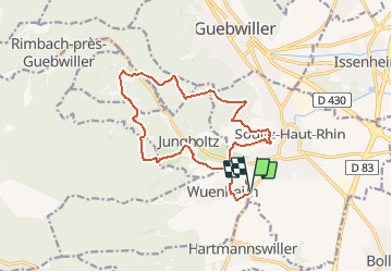
Tour Mountainbike von 14,4 km verfügbar auf Großer Osten, Oberelsass, Sulz/Oberelsass. Diese Tour wird von tracegps vorgeschlagen.
Beschreibung
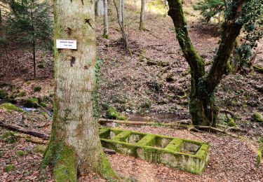
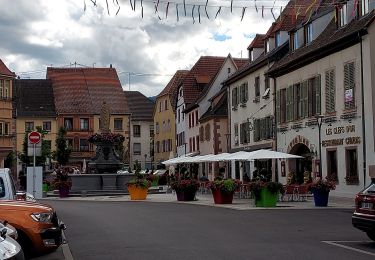
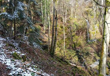
Espace VTT - FFC Région de Guebwiller - n°13 - Circuit de Sainte-Anne Circuit officiel labellisé par la Fédération Française de Cyclisme. Cimetière israélite de Jungholtz, basilique de Thierenbach, centre de cure de Sainte-Anne, église Saint-Pierre et Paul de Rimbach-Zell, oratoire du Bildstoecklé, tels sont les sites que vous allez rencontrer sur ce circuit de 13,65 km. Jusqu’à la fin du XIXème siècle, Jungholtz était divisé par le ruisseau Rimbach, la rive gauche appartenant à Rimbach, la rive droite à Soultz. Le château, appartenant au Schauenbourg, seigneurs de Jungholtz, est détruit pendant la Révolution. Une grande partie du terrain est acquise par la communauté juive pour en faire un cimetière, le seul du Haut-Rhin avec celui de Hegenheim. Entre 1789 et 1987, environ 3000 personnes ont été enterrées sur une surface de 3 hectares. En 1880, lors de la fondation de la commune et de la paroisse, le pèlerinage de Thierenbach devient église paroissiale. Le territoire de Rimbach-Zell est occupé dès le Moyen-Âge. Au sud-est du village subsistent des vestiges d’un château du Xème-XIème siècle. Rimbach-Zell était une dépendance du baillage de Soultz et la commanderie de Malte y possédait la moitié de la Dîme. Ces derniers devaient également entretenir un étang qui servait de réservoir en cas d’incendie. Le nombre d’habitants en augmentation jusqu’au début de la Première Guerre mondiale, n’a depuis cessé de décroître. Topo guide VTT en vente à l’Office du Tourisme de Guebwiller-Soultz et les Pays du Florival - Antenne de Guebwiller - 71 Rue de la République - 68500 – Guebwiller Tel. : 03 89 76 10 63 - Fax :03 89 76 52 72 Crédit photos ; ©Pays d’Art et d’Histoire de la Région de Guebwiller
Ort
Kommentare
Touren in der Umgebung
![Tour Wandern Sulz/Oberelsass - Hartmannswillerkopf - Circuit découverte - Photo](https://media.geolcdn.com/t/375/260/ext.jpg?maxdim=2&url=https%3A%2F%2Fservices.sitytrail.com%2FGeolivesWS%2FDownloadMedia.ashx%3FTrailID%3D422294%26Media%3Dfix__20150517124954.jpg)
![Wandern Wandern](https://static1.geolcdn.com/sitytour/trail-icons/101.png)
Wandern
![](/images/other/stat-length.png)
![](https://static1.geolcdn.com/siteimages/upload/files/16400158638029165_repeat_loop_refresh_sync_direction_icon.png)
![Tour Mountainbike Gebweiler - P4 Circuits du Florival 2021 - Photo](https://media.geolcdn.com/t/375/260/ext.jpg?maxdim=2&url=https%3A%2F%2Fstatic1.geolcdn.com%2Fsiteimages%2Fupload%2Ffiles%2F1524743154velo.jpg)
![Mountainbike Mountainbike](https://static1.geolcdn.com/sitytour/trail-icons/202.png)
Mountainbike
![](/images/other/stat-length.png)
![](https://static1.geolcdn.com/siteimages/upload/files/16400158638029165_repeat_loop_refresh_sync_direction_icon.png)
![Tour Wandern Sulz/Oberelsass - Rando Marcheurs..04/04_2025 - Photo](https://media.geolcdn.com/t/375/260/2ab5dad5-2554-412a-abd7-9d4222ed2a04.jpg&format=jpg&maxdim=2)
![Wandern Wandern](https://static1.geolcdn.com/sitytour/trail-icons/101.png)
Wandern
![](/images/other/stat-length.png)
![](https://static1.geolcdn.com/siteimages/upload/files/16400158638029165_repeat_loop_refresh_sync_direction_icon.png)
![Tour Wandern Jungholz - Rando Retrouvailles...01/03/2024.par Jean Marc - Photo](https://media.geolcdn.com/t/375/260/a9ee6325-7504-4fd2-a0fe-1e1c5b8164cc.jpg&format=jpg&maxdim=2)
![Wandern Wandern](https://static1.geolcdn.com/sitytour/trail-icons/101.png)
Wandern
![](/images/other/stat-length.png)
![](https://static1.geolcdn.com/siteimages/upload/files/16400158638029165_repeat_loop_refresh_sync_direction_icon.png)
![Tour Wandern Wattweiler - Wattwiller - Domaine du Hirtz (30/03/2023) - Photo](https://media.geolcdn.com/t/375/260/fba38f94-41c6-40ad-89c3-14f41fe23918.jpg&format=jpg&maxdim=2)
![Wandern Wandern](https://static1.geolcdn.com/sitytour/trail-icons/101.png)
Wandern
![](/images/other/stat-length.png)
![](https://static1.geolcdn.com/siteimages/upload/files/16400158638029165_repeat_loop_refresh_sync_direction_icon.png)
![Tour Wandern Sulz/Oberelsass - Rando avec 0mar et Mouloud..18/02/2023 - Photo](https://media.geolcdn.com/t/375/260/2a55124f-fd73-4322-bdd9-d60b0e32c3a6.jpg&format=jpg&maxdim=2)
![Wandern Wandern](https://static1.geolcdn.com/sitytour/trail-icons/101.png)
Wandern
![](/images/other/stat-length.png)
![](https://static1.geolcdn.com/siteimages/upload/files/16400158638029165_repeat_loop_refresh_sync_direction_icon.png)
![Tour Rennrad Isenheim - EXT-65 Issenheim-01 - Photo](https://media.geolcdn.com/t/375/260/bc8eb7c6-a83e-420e-811a-8fc41d20c1b6.jpg&format=jpg&maxdim=2)
![Rennrad Rennrad](https://static1.geolcdn.com/sitytour/trail-icons/201.png)
Rennrad
![](/images/other/stat-length.png)
![](https://static1.geolcdn.com/siteimages/upload/files/16400158638029165_repeat_loop_refresh_sync_direction_icon.png)
![Tour Wandern Sulz/Oberelsass - Wuenheim - Kohlschlag (18/03/2021) - Photo](https://media.geolcdn.com/t/375/260/8db7daf1-accf-4376-8062-b388fe01455d.jpg&format=jpg&maxdim=2)
![Wandern Wandern](https://static1.geolcdn.com/sitytour/trail-icons/101.png)
Wandern
![](/images/other/stat-length.png)
![](https://static1.geolcdn.com/siteimages/upload/files/16400158638029165_repeat_loop_refresh_sync_direction_icon.png)
![Tour Wandern Gebweiler - Col du Dreibannstein (25/02/2021) - Photo](https://media.geolcdn.com/t/375/260/01477b0b-f1df-4927-be2f-bf38479cee4e.jpg&format=jpg&maxdim=2)
![Wandern Wandern](https://static1.geolcdn.com/sitytour/trail-icons/101.png)
Wandern
![](/images/other/stat-length.png)
![](https://static1.geolcdn.com/siteimages/upload/files/16400158638029165_repeat_loop_refresh_sync_direction_icon.png)