![](/images/other/stat-length.png)
![Tour Wandern Neussargues en Pinatelle - Le bois de la Pinatelle - Photo](https://media.geolcdn.com/t/1900/400/ext.pjpeg?maxdim=2&url=https%3A%2F%2Fstatic1.geolcdn.com%2Fsiteimages%2Fupload%2Ffiles%2F1553511878bg_sport_marche.png)
Le bois de la Pinatelle
tracegps
Benutzer
![Länge](/images/other/stat-length.png)
Länge
10,5 km
![Maximale Höhe](https://static1.geolcdn.com/siteimages/upload/files/1508320355ic_sort_altitude_max_24dp.png)
Maximale Höhe
1145 m
![Positive Höhendifferenz](https://static1.geolcdn.com/siteimages/upload/files/1508320355ic_sort_den_pos_24dp.png)
Positive Höhendifferenz
222 m
![Km-Effort](/images/other/stat-length.png)
Km-Effort
13,5 km
![Min. Höhe](https://static1.geolcdn.com/siteimages/upload/files/1508320355ic_sort_altitude_min_24dp.png)
Min. Höhe
1003 m
![Negative Höhendifferenz](https://static1.geolcdn.com/siteimages/upload/files/1508320355ic_sort_den_neg_24dp.png)
Negative Höhendifferenz
216 m
![Boucle](https://static1.geolcdn.com/siteimages/upload/files/16400158638029165_repeat_loop_refresh_sync_direction_icon.png)
Boucle
Ja
Erstellungsdatum :
2014-12-10 00:00:00.0
Letzte Änderung :
2014-12-10 00:00:00.0
![Wandern](https://static1.geolcdn.com/sitytour/trail-icons/101.png)
2h49
Schwierigkeit : Medium
![Scannen Sie diesen QR-Code, um die Tour in der SityTrail-Anwendung zu öffnen](https://capi.geolives.com/qq0zvz2zws4bq2lad0pu/sitytour/trails/105473/qr.png?size=200)
Kostenlosegpshiking-Anwendung
Über SityTrail
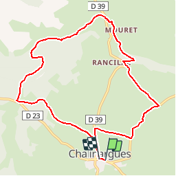
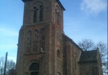
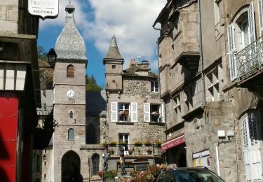
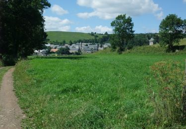
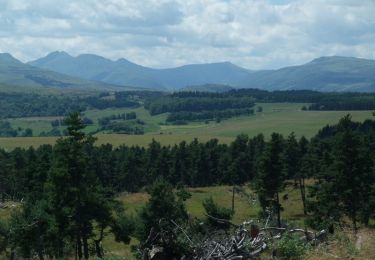
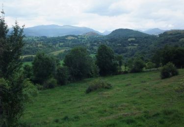
Tour Wandern von 10,5 km verfügbar auf Auvergne-Rhone-Alpen, Cantal, Neussargues en Pinatelle. Diese Tour wird von tracegps vorgeschlagen.
Beschreibung
Départ depuis le « couderc » de Chalinargues. Parcours plat ou presque. Chemins larges, empierrés ou herbeux. A faire en famille sans problème.
Ort
Land:
France
Region :
Auvergne-Rhone-Alpen
Abteilung/Provinz :
Cantal
Kommune :
Neussargues en Pinatelle
Standort:
Chalinargues
Gehen Sie:(Dec)
Gehen Sie:(UTM)
494812 ; 5000164 (31T) N.
Kommentare
Touren in der Umgebung
![Tour Wandern Neussargues en Pinatelle - Sentier des vieilles pierres - Photo](https://media.geolcdn.com/t/375/260/ext.jpg?maxdim=2&url=https%3A%2F%2Fservices.sitytrail.com%2FGeolivesWS%2FDownloadMedia.ashx%3FTrailID%3D103674%26Media%3D6151_3.jpg)
![Wandern Wandern](https://static1.geolcdn.com/sitytour/trail-icons/101.png)
Sentier des vieilles pierres
Wandern
Schwierig
(1)
Neussargues en Pinatelle,
Auvergne-Rhone-Alpen,
Cantal,
France
![](/images/other/stat-length.png)
13,9 km | 18,4 km-effort
4h 0min
![](https://static1.geolcdn.com/siteimages/upload/files/16400158638029165_repeat_loop_refresh_sync_direction_icon.png)
Nein
![Tour Reiten Neussargues en Pinatelle - chalinargue 2 - Photo](https://media.geolcdn.com/t/375/260/ext.jpg?maxdim=2&url=https%3A%2F%2Fstatic1.geolcdn.com%2Fsiteimages%2Fupload%2Ffiles%2F1524743154cheval.jpg)
![Reiten Reiten](https://static1.geolcdn.com/sitytour/trail-icons/301.png)
chalinargue 2
Reiten
Einfach
(1)
Neussargues en Pinatelle,
Auvergne-Rhone-Alpen,
Cantal,
France
![](/images/other/stat-length.png)
26 km | 34 km-effort
5h 14min
![](https://static1.geolcdn.com/siteimages/upload/files/16400158638029165_repeat_loop_refresh_sync_direction_icon.png)
Ja
![Tour Wandern Neussargues en Pinatelle - Cantal 2015 Les vieilles pierres - Photo](https://media.geolcdn.com/t/375/260/ext.jpg?maxdim=2&url=https%3A%2F%2Fservices.sitytrail.com%2FGeolivesWS%2FDownloadMedia.ashx%3FTrailID%3D434344%26Media%3Dfix__20150604161021.jpg)
![Wandern Wandern](https://static1.geolcdn.com/sitytour/trail-icons/101.png)
Cantal 2015 Les vieilles pierres
Wandern
Einfach
Neussargues en Pinatelle,
Auvergne-Rhone-Alpen,
Cantal,
France
![](/images/other/stat-length.png)
15,7 km | 21 km-effort
4h 27min
![](https://static1.geolcdn.com/siteimages/upload/files/16400158638029165_repeat_loop_refresh_sync_direction_icon.png)
Ja
![Tour Wandern Neussargues en Pinatelle - La Via Arverna (Neussargues - Murat) - Photo](https://media.geolcdn.com/t/375/260/ext.jpg?maxdim=2&url=https%3A%2F%2Fservices.sitytrail.com%2FGeolivesWS%2FDownloadMedia.ashx%3FTrailID%3D173007%26Media%3D14507_6.jpg)
![Wandern Wandern](https://static1.geolcdn.com/sitytour/trail-icons/101.png)
La Via Arverna (Neussargues - Murat)
Wandern
Schwierig
Neussargues en Pinatelle,
Auvergne-Rhone-Alpen,
Cantal,
France
![](/images/other/stat-length.png)
24 km | 31 km-effort
6h 45min
![](https://static1.geolcdn.com/siteimages/upload/files/16400158638029165_repeat_loop_refresh_sync_direction_icon.png)
Nein
![Tour Wandern Murat - Murat - Photo](https://media.geolcdn.com/t/375/260/ext.jpg?maxdim=2&url=https%3A%2F%2Fservices.sitytrail.com%2FGeolivesWS%2FDownloadMedia.ashx%3FTrailID%3D167890%26Media%3D20121230152910.jpg)
![Wandern Wandern](https://static1.geolcdn.com/sitytour/trail-icons/101.png)
Murat
Wandern
Sehr leicht
Murat,
Auvergne-Rhone-Alpen,
Cantal,
France
![](/images/other/stat-length.png)
5,5 km | 8 km-effort
1h 13min
![](https://static1.geolcdn.com/siteimages/upload/files/16400158638029165_repeat_loop_refresh_sync_direction_icon.png)
Ja
![Tour Wandern Murat - Découverte de Murat dans le Cantal - Photo](https://media.geolcdn.com/t/375/260/de944ad8-d50c-4333-883a-543ae65c345b.jpg&format=jpg&maxdim=2)
![Wandern Wandern](https://static1.geolcdn.com/sitytour/trail-icons/101.png)
Découverte de Murat dans le Cantal
Wandern
Einfach
Murat,
Auvergne-Rhone-Alpen,
Cantal,
France
![](/images/other/stat-length.png)
7,6 km | 12,3 km-effort
1h 50min
![](https://static1.geolcdn.com/siteimages/upload/files/16400158638029165_repeat_loop_refresh_sync_direction_icon.png)
Ja
![Tour Wandern Neussargues en Pinatelle - Chavagnac - Photo](https://media.geolcdn.com/t/375/260/ext.jpg?maxdim=2&url=https%3A%2F%2Fservices.sitytrail.com%2FGeolivesWS%2FDownloadMedia.ashx%3FTrailID%3D105469%26Media%3D9210_2.jpg)
![Wandern Wandern](https://static1.geolcdn.com/sitytour/trail-icons/101.png)
Chavagnac
Wandern
Medium
Neussargues en Pinatelle,
Auvergne-Rhone-Alpen,
Cantal,
France
![](/images/other/stat-length.png)
9,5 km | 12,4 km-effort
3h 0min
![](https://static1.geolcdn.com/siteimages/upload/files/16400158638029165_repeat_loop_refresh_sync_direction_icon.png)
Ja
![Tour Wandern Neussargues en Pinatelle - La roche du Pic près La Boissonnière - Photo](https://media.geolcdn.com/t/375/260/ext.jpg?maxdim=2&url=https%3A%2F%2Fservices.sitytrail.com%2FGeolivesWS%2FDownloadMedia.ashx%3FTrailID%3D105467%26Media%3D9208_1.jpg)
![Wandern Wandern](https://static1.geolcdn.com/sitytour/trail-icons/101.png)
La roche du Pic près La Boissonnière
Wandern
Medium
Neussargues en Pinatelle,
Auvergne-Rhone-Alpen,
Cantal,
France
![](/images/other/stat-length.png)
8,3 km | 11 km-effort
2h 19min
![](https://static1.geolcdn.com/siteimages/upload/files/16400158638029165_repeat_loop_refresh_sync_direction_icon.png)
Ja
![Tour Wandern Virargues - Farges - Photo](https://media.geolcdn.com/t/375/260/ext.jpg?maxdim=2&url=https%3A%2F%2Fservices.sitytrail.com%2FGeolivesWS%2FDownloadMedia.ashx%3FTrailID%3D105466%26Media%3D9207_1.jpg)
![Wandern Wandern](https://static1.geolcdn.com/sitytour/trail-icons/101.png)
Farges
Wandern
Medium
Virargues,
Auvergne-Rhone-Alpen,
Cantal,
France
![](/images/other/stat-length.png)
8,8 km | 11,6 km-effort
2h 30min
![](https://static1.geolcdn.com/siteimages/upload/files/16400158638029165_repeat_loop_refresh_sync_direction_icon.png)
Ja