![](/images/other/stat-length.png)
![Tour Mountainbike Baratier - Espace VTT FFC de l'Embrunais Savinois - Circuit n° 14 - Boucle de la Mûre - Photo](https://media.geolcdn.com/t/1900/400/ext.pjpeg?maxdim=2&url=https%3A%2F%2Fservices.sitytrail.com%2FGeolivesWS%2FDownloadMedia.ashx%3FTrailID%3D105432%26Media%3D9163_2.jpg)
Espace VTT FFC de l'Embrunais Savinois - Circuit n° 14 - Boucle de la Mûre
tracegps
Benutzer
![Länge](/images/other/stat-length.png)
![Maximale Höhe](https://static1.geolcdn.com/siteimages/upload/files/1508320355ic_sort_altitude_max_24dp.png)
![Positive Höhendifferenz](https://static1.geolcdn.com/siteimages/upload/files/1508320355ic_sort_den_pos_24dp.png)
![Km-Effort](/images/other/stat-length.png)
![Min. Höhe](https://static1.geolcdn.com/siteimages/upload/files/1508320355ic_sort_altitude_min_24dp.png)
![Negative Höhendifferenz](https://static1.geolcdn.com/siteimages/upload/files/1508320355ic_sort_den_neg_24dp.png)
![Boucle](https://static1.geolcdn.com/siteimages/upload/files/16400158638029165_repeat_loop_refresh_sync_direction_icon.png)
![Mountainbike](https://static1.geolcdn.com/sitytour/trail-icons/202.png)
34m
Schwierigkeit : Medium
![Scannen Sie diesen QR-Code, um die Tour in der SityTrail-Anwendung zu öffnen](https://capi.geolives.com/qq0zvz2zws4bq2lad0pu/sitytour/trails/105432/qr.png?size=200)
Kostenlosegpshiking-Anwendung
Über SityTrail
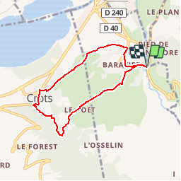
Tour Mountainbike von 6,6 km verfügbar auf Provence-Alpes-Côte d'Azur, Hochalpen, Baratier. Diese Tour wird von tracegps vorgeschlagen.
Beschreibung
Espace VTT FFC de l'Embrunais Savinois - Circuit n° 14 - Boucle de la Mûre Circuit labellisé par la Fédération Française de Cyclisme. Départ : Baratier, parking avant le pont sur le torrent de Vachère. C’est un circuit facile destiné aux débutants ou aux familles souhaitant s’essayer au VTT. Le circuit passe dans les villages de Crots et de Baratiers, qu’il ne faut pas hésiter à visiter. La montée au-dessus de Baratier offre un joli point de vue sur le lac de Serre-Ponçon. Entre Crots et Baratier, le chemin circule au bord d’un canal, ce qui le rend bien agréable.
Ort
Kommentare
Touren in der Umgebung
![Tour Wandern Crots - Le Cirque de Morgon - Photo](https://media.geolcdn.com/t/375/260/ext.jpg?maxdim=2&url=https%3A%2F%2Fservices.sitytrail.com%2FGeolivesWS%2FDownloadMedia.ashx%3FTrailID%3D109626%26Media%3D4261_1.jpg)
![Wandern Wandern](https://static1.geolcdn.com/sitytour/trail-icons/101.png)
Wandern
![](/images/other/stat-length.png)
![](https://static1.geolcdn.com/siteimages/upload/files/16400158638029165_repeat_loop_refresh_sync_direction_icon.png)
![Tour Wandern Crots - Morgon par le Grand Clot - Photo](https://media.geolcdn.com/t/375/260/2470b249-9732-40d6-87a8-fc728b4285cc.jpg&format=jpg&maxdim=2)
![Wandern Wandern](https://static1.geolcdn.com/sitytour/trail-icons/101.png)
Wandern
![](/images/other/stat-length.png)
![](https://static1.geolcdn.com/siteimages/upload/files/16400158638029165_repeat_loop_refresh_sync_direction_icon.png)
![Tour Wandern Saint-Sauveur - 2012-08-07 Méale - Photo](https://media.geolcdn.com/t/375/260/ext.jpg?maxdim=2&url=https%3A%2F%2Fservices.sitytrail.com%2FGeolivesWS%2FDownloadMedia.ashx%3FTrailID%3D145125%26Media%3D8f8ba6a5-bed5-4779-b0c7-5d5fa06c0aa0.jpeg)
![Wandern Wandern](https://static1.geolcdn.com/sitytour/trail-icons/101.png)
Wandern
![](/images/other/stat-length.png)
![](https://static1.geolcdn.com/siteimages/upload/files/16400158638029165_repeat_loop_refresh_sync_direction_icon.png)
![Tour Wandern Crots - Grand Morgon - Photo](https://media.geolcdn.com/t/375/260/c2ea8bef-d143-4c62-a26e-6fbe8e0329c8.jpg&format=jpg&maxdim=2)
![Wandern Wandern](https://static1.geolcdn.com/sitytour/trail-icons/101.png)
Wandern
![](/images/other/stat-length.png)
![](https://static1.geolcdn.com/siteimages/upload/files/16400158638029165_repeat_loop_refresh_sync_direction_icon.png)
![Tour Wandern Crots - SityTrail - 2251353 - morgon-par-le-grand-clot - Photo](https://media.geolcdn.com/t/375/260/1bb998f8-1a6a-4350-bb2c-9f136211e7d5.jpg&format=jpg&maxdim=2)
![Wandern Wandern](https://static1.geolcdn.com/sitytour/trail-icons/101.png)
Wandern
![](/images/other/stat-length.png)
![](https://static1.geolcdn.com/siteimages/upload/files/16400158638029165_repeat_loop_refresh_sync_direction_icon.png)
![Tour Wandern Crots - Embrunais - Cirque de Morgon - 9.2km 550m 3h20 - 2018 06 25 - public - Photo](https://media.geolcdn.com/t/375/260/ext.jpg?maxdim=2&url=https%3A%2F%2Fservices.sitytrail.com%2FGeolivesWS%2FDownloadMedia.ashx%3FTrailID%3D999318%26Media%3Dfix__20180625114434.jpg)
![Wandern Wandern](https://static1.geolcdn.com/sitytour/trail-icons/101.png)
Wandern
![](/images/other/stat-length.png)
![](https://static1.geolcdn.com/siteimages/upload/files/16400158638029165_repeat_loop_refresh_sync_direction_icon.png)
![Tour Wandern Embrun - Embrun - 3.4km 90m 1h00 - 2018 06 26 - privé - Photo](https://media.geolcdn.com/t/375/260/ext.jpg?maxdim=2&url=https%3A%2F%2Fservices.sitytrail.com%2FGeolivesWS%2FDownloadMedia.ashx%3FTrailID%3D999315%26Media%3Dfix__20180626102346.jpg)
![Wandern Wandern](https://static1.geolcdn.com/sitytour/trail-icons/101.png)
Wandern
![](/images/other/stat-length.png)
![](https://static1.geolcdn.com/siteimages/upload/files/16400158638029165_repeat_loop_refresh_sync_direction_icon.png)
![Tour Wandern Crots - EMBRUN Jour 2 : Le Cirque du Morgon - Photo](https://media.geolcdn.com/t/375/260/523a98e5-45d0-4ac2-9ff0-6c4448bdd4f5.jpg&format=jpg&maxdim=2)
![Wandern Wandern](https://static1.geolcdn.com/sitytour/trail-icons/101.png)
Wandern
![](/images/other/stat-length.png)
![](https://static1.geolcdn.com/siteimages/upload/files/16400158638029165_repeat_loop_refresh_sync_direction_icon.png)
![Tour Wandern Embrun - embrun - Photo](https://media.geolcdn.com/t/375/260/983747e0-b406-4f08-9e49-4a70208cddfc.jpg&format=jpg&maxdim=2)
![Wandern Wandern](https://static1.geolcdn.com/sitytour/trail-icons/101.png)
Wandern
![](/images/other/stat-length.png)
![](https://static1.geolcdn.com/siteimages/upload/files/16400158638029165_repeat_loop_refresh_sync_direction_icon.png)