![](/images/other/stat-length.png)
![Tour Mountainbike Chambœuf - Bords de Loire - Chamboeuf - Photo](https://media.geolcdn.com/t/1900/400/ext.pjpeg?maxdim=2&url=https%3A%2F%2Fservices.sitytrail.com%2FGeolivesWS%2FDownloadMedia.ashx%3FTrailID%3D105243%26Media%3D8897_1.jpg)
Bords de Loire - Chamboeuf
tracegps
Benutzer
![Länge](/images/other/stat-length.png)
Länge
22 km
![Maximale Höhe](https://static1.geolcdn.com/siteimages/upload/files/1508320355ic_sort_altitude_max_24dp.png)
Maximale Höhe
431 m
![Positive Höhendifferenz](https://static1.geolcdn.com/siteimages/upload/files/1508320355ic_sort_den_pos_24dp.png)
Positive Höhendifferenz
193 m
![Km-Effort](/images/other/stat-length.png)
Km-Effort
25 km
![Min. Höhe](https://static1.geolcdn.com/siteimages/upload/files/1508320355ic_sort_altitude_min_24dp.png)
Min. Höhe
342 m
![Negative Höhendifferenz](https://static1.geolcdn.com/siteimages/upload/files/1508320355ic_sort_den_neg_24dp.png)
Negative Höhendifferenz
192 m
![Boucle](https://static1.geolcdn.com/siteimages/upload/files/16400158638029165_repeat_loop_refresh_sync_direction_icon.png)
Boucle
Ja
Erstellungsdatum :
2014-12-10 00:00:00.0
Letzte Änderung :
2014-12-10 00:00:00.0
![Mountainbike](https://static1.geolcdn.com/sitytour/trail-icons/202.png)
2h00
Schwierigkeit : Medium
![Scannen Sie diesen QR-Code, um die Tour in der SityTrail-Anwendung zu öffnen](https://capi.geolives.com/qq0zvz2zws4bq2lad0pu/sitytour/trails/105243/qr.png?size=200)
Kostenlosegpshiking-Anwendung
Über SityTrail
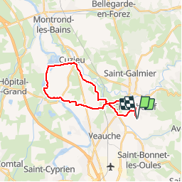
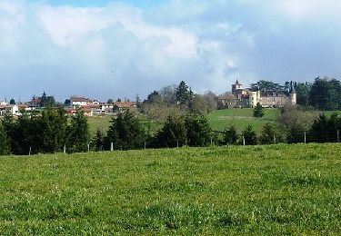
Tour Mountainbike von 22 km verfügbar auf Auvergne-Rhone-Alpen, Loire, Chambœuf. Diese Tour wird von tracegps vorgeschlagen.
Beschreibung
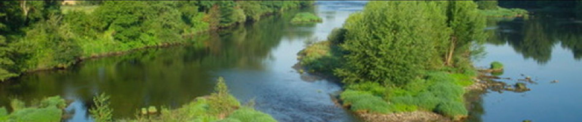
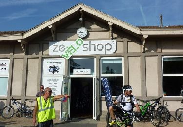
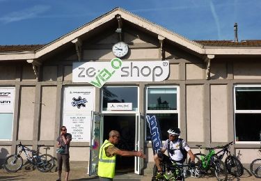
Boucle VTT sur des chemins agréables et de niveau plutôt facile. Passage au bord du fleuve Loire, de nombreux canards, espace de tranquillité. Le circuit peut se faire dans les 2 sens.
Ort
Land:
France
Region :
Auvergne-Rhone-Alpen
Abteilung/Provinz :
Loire
Kommune :
Chambœuf
Standort:
Unknown
Gehen Sie:(Dec)
Gehen Sie:(UTM)
603123 ; 5047317 (31T) N.
Kommentare
Touren in der Umgebung
![Tour Wandern Saint-Héand - St Heand, Montrond, Mont Morin, Pierre de la Bauche et retour St Heand - Photo](https://media.geolcdn.com/t/375/260/ext.jpg?maxdim=2&url=https%3A%2F%2Fstatic1.geolcdn.com%2Fsiteimages%2Fupload%2Ffiles%2F1553511878bg_sport_marche.png)
![Wandern Wandern](https://static1.geolcdn.com/sitytour/trail-icons/101.png)
St Heand, Montrond, Mont Morin, Pierre de la Bauche et retour St Heand
Wandern
Medium
(1)
Saint-Héand,
Auvergne-Rhone-Alpen,
Loire,
France
![](/images/other/stat-length.png)
16 km | 23 km-effort
5h 20min
![](https://static1.geolcdn.com/siteimages/upload/files/16400158638029165_repeat_loop_refresh_sync_direction_icon.png)
Ja
![Tour Wandern Saint-Bonnet-les-Oules - Saint-Bonnet-les-Oules du 26-12-2022 - Photo](https://media.geolcdn.com/t/375/260/b0909c52-48d0-4fb3-a021-6e2066fe45fd.jpg&format=jpg&maxdim=2)
![Wandern Wandern](https://static1.geolcdn.com/sitytour/trail-icons/101.png)
Saint-Bonnet-les-Oules du 26-12-2022
Wandern
Schwierig
Saint-Bonnet-les-Oules,
Auvergne-Rhone-Alpen,
Loire,
France
![](/images/other/stat-length.png)
10,8 km | 14,5 km-effort
2h 17min
![](https://static1.geolcdn.com/siteimages/upload/files/16400158638029165_repeat_loop_refresh_sync_direction_icon.png)
Ja
![Tour Wandern Andrézieux-Bouthéon - autour de Boutheon - Photo](https://media.geolcdn.com/t/375/260/2650ae89-7750-43af-bfc7-bc43f795b3df.jpg&format=jpg&maxdim=2)
![Wandern Wandern](https://static1.geolcdn.com/sitytour/trail-icons/101.png)
autour de Boutheon
Wandern
Sehr leicht
Andrézieux-Bouthéon,
Auvergne-Rhone-Alpen,
Loire,
France
![](/images/other/stat-length.png)
7,6 km | 8,7 km-effort
1h 46min
![](https://static1.geolcdn.com/siteimages/upload/files/16400158638029165_repeat_loop_refresh_sync_direction_icon.png)
Ja
![Tour Mountainbike Veauche - Par Monts et par Veauche (2014-VTT-70km) - Veauche - Photo](https://media.geolcdn.com/t/375/260/ext.jpg?maxdim=2&url=https%3A%2F%2Fservices.sitytrail.com%2FGeolivesWS%2FDownloadMedia.ashx%3FTrailID%3D318103%26Media%3D17562_6.jpg)
![Mountainbike Mountainbike](https://static1.geolcdn.com/sitytour/trail-icons/202.png)
Par Monts et par Veauche (2014-VTT-70km) - Veauche
Mountainbike
Sehr schwierig
Veauche,
Auvergne-Rhone-Alpen,
Loire,
France
![](/images/other/stat-length.png)
69 km | 90 km-effort
6h 0min
![](https://static1.geolcdn.com/siteimages/upload/files/16400158638029165_repeat_loop_refresh_sync_direction_icon.png)
Ja
![Tour Mountainbike Veauche - Par Monts et par Veauche (2014-VTT-45km) - Veauche - Photo](https://media.geolcdn.com/t/375/260/ext.jpg?maxdim=2&url=https%3A%2F%2Fservices.sitytrail.com%2FGeolivesWS%2FDownloadMedia.ashx%3FTrailID%3D318102%26Media%3D17561_6.jpg)
![Mountainbike Mountainbike](https://static1.geolcdn.com/sitytour/trail-icons/202.png)
Par Monts et par Veauche (2014-VTT-45km) - Veauche
Mountainbike
Schwierig
Veauche,
Auvergne-Rhone-Alpen,
Loire,
France
![](/images/other/stat-length.png)
47 km | 61 km-effort
4h 0min
![](https://static1.geolcdn.com/siteimages/upload/files/16400158638029165_repeat_loop_refresh_sync_direction_icon.png)
Ja
![Tour Mountainbike Saint-Médard-en-Forez - La Randonnée des Moulins (2014-VTT-26km) - Saint Médard en Forez - Photo](https://media.geolcdn.com/t/375/260/ext.jpg?maxdim=2&url=https%3A%2F%2Fservices.sitytrail.com%2FGeolivesWS%2FDownloadMedia.ashx%3FTrailID%3D317619%26Media%3D16885_6.jpg)
![Mountainbike Mountainbike](https://static1.geolcdn.com/sitytour/trail-icons/202.png)
La Randonnée des Moulins (2014-VTT-26km) - Saint Médard en Forez
Mountainbike
Sehr schwierig
Saint-Médard-en-Forez,
Auvergne-Rhone-Alpen,
Loire,
France
![](/images/other/stat-length.png)
26 km | 35 km-effort
3h 0min
![](https://static1.geolcdn.com/siteimages/upload/files/16400158638029165_repeat_loop_refresh_sync_direction_icon.png)
Ja
![Tour Wandern Saint-Médard-en-Forez - La Randonnée des Moulins (2014-VTT-26km) - Saint Médard en Forez - Photo](https://media.geolcdn.com/t/375/260/ext.jpg?maxdim=2&url=https%3A%2F%2Fservices.sitytrail.com%2FGeolivesWS%2FDownloadMedia.ashx%3FTrailID%3D317618%26Media%3D16885_6.jpg)
![Wandern Wandern](https://static1.geolcdn.com/sitytour/trail-icons/101.png)
La Randonnée des Moulins (2014-VTT-26km) - Saint Médard en Forez
Wandern
Sehr schwierig
Saint-Médard-en-Forez,
Auvergne-Rhone-Alpen,
Loire,
France
![](/images/other/stat-length.png)
26 km | 35 km-effort
6h 0min
![](https://static1.geolcdn.com/siteimages/upload/files/16400158638029165_repeat_loop_refresh_sync_direction_icon.png)
Ja
![Tour Laufen Saint-Galmier - La Rose de Saint-Galmier - Photo](https://media.geolcdn.com/t/375/260/ext.jpg?maxdim=2&url=https%3A%2F%2Fservices.sitytrail.com%2FGeolivesWS%2FDownloadMedia.ashx%3FTrailID%3D317008%26Media%3D16145_6.jpg)
![Laufen Laufen](https://static1.geolcdn.com/sitytour/trail-icons/103.png)
La Rose de Saint-Galmier
Laufen
Einfach
Saint-Galmier,
Auvergne-Rhone-Alpen,
Loire,
France
![](/images/other/stat-length.png)
4 km | 4,4 km-effort
45min
![](https://static1.geolcdn.com/siteimages/upload/files/16400158638029165_repeat_loop_refresh_sync_direction_icon.png)
Ja
![Tour Wandern Saint-Galmier - La Rose de Saint-Galmier - Photo](https://media.geolcdn.com/t/375/260/ext.jpg?maxdim=2&url=https%3A%2F%2Fservices.sitytrail.com%2FGeolivesWS%2FDownloadMedia.ashx%3FTrailID%3D317007%26Media%3D16145_6.jpg)
![Wandern Wandern](https://static1.geolcdn.com/sitytour/trail-icons/101.png)
La Rose de Saint-Galmier
Wandern
Einfach
Saint-Galmier,
Auvergne-Rhone-Alpen,
Loire,
France
![](/images/other/stat-length.png)
4 km | 4,4 km-effort
1h 30min
![](https://static1.geolcdn.com/siteimages/upload/files/16400158638029165_repeat_loop_refresh_sync_direction_icon.png)
Ja