![](/images/other/stat-length.png)
![Tour Mountainbike Flamanville - Rando des Caps 2009 - Flamanville - Photo](https://media.geolcdn.com/t/1900/400/ext.pjpeg?maxdim=2&url=https%3A%2F%2Fstatic1.geolcdn.com%2Fsiteimages%2Fupload%2Ffiles%2F1524743154velo.jpg)
Rando des Caps 2009 - Flamanville
tracegps
Benutzer
![Länge](/images/other/stat-length.png)
![Maximale Höhe](https://static1.geolcdn.com/siteimages/upload/files/1508320355ic_sort_altitude_max_24dp.png)
![Positive Höhendifferenz](https://static1.geolcdn.com/siteimages/upload/files/1508320355ic_sort_den_pos_24dp.png)
![Km-Effort](/images/other/stat-length.png)
![Min. Höhe](https://static1.geolcdn.com/siteimages/upload/files/1508320355ic_sort_altitude_min_24dp.png)
![Negative Höhendifferenz](https://static1.geolcdn.com/siteimages/upload/files/1508320355ic_sort_den_neg_24dp.png)
![Boucle](https://static1.geolcdn.com/siteimages/upload/files/16400158638029165_repeat_loop_refresh_sync_direction_icon.png)
![Mountainbike](https://static1.geolcdn.com/sitytour/trail-icons/202.png)
2h30
Schwierigkeit : Schwierig
![Scannen Sie diesen QR-Code, um die Tour in der SityTrail-Anwendung zu öffnen](https://capi.geolives.com/qq0zvz2zws4bq2lad0pu/sitytour/trails/105240/qr.png?size=200)
Kostenlosegpshiking-Anwendung
Über SityTrail
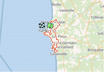
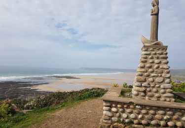
Tour Mountainbike von 46 km verfügbar auf Normandie, Manche, Flamanville. Diese Tour wird von tracegps vorgeschlagen.
Beschreibung
Randonnée pratiquée dans le cadre de la "Rando des Caps" organisée par le club cache rando dont je félicite l'organisation ainsi que les sympathiques bénévoles qui nous ont bichonnés pendant les ravitaillements. Je conseille vivement aux vététistes désirant passer un bon moment à venir s'échouer par Flamanville pour participer a une prochaine rando organisée par cache rando. Le club "VTT les Haguards" vous invite à venir nous rejoindre les dimanches matins à 8h45 dans un rayon de 20 km autour de Cherbourg afin de découvrir de fabuleux sentiers dans une ambiance sportive et conviviale. Nous roulons environ 3h et nous adaptons notre allure aux vttistes présents afin de permettre aux nouveaux arrivants de s'adapter à notre rythme, et si il le faut nous formons des groupes afin de satisfaire tous les participants. Les Haguards c'est aussi des adhérents qui n'hésitent pas à se déplacer sur des épreuves réputées de l'ouest de la France tel que "La Gamelle Trophy, la Jean Racine, les Sentiers de la Hague etc......". Enfin, les Haguards ne sont pas sectaires et apprécient aussi de pratiquer d'autres disciplines comme le triathlon, la course à pied, le vélo de route, etc... Donc si vous en avez assez de pédaler seul, contactez-nous par mail ou sur Fessebouc "Vtt les Haguards" et je vous indiquerai notre prochain lieu de RDV. Sur notre site il est indiqué sur la page d'accueil que nous roulons beaucoup dans la Hague mais le calendrier mettra en évidence que nous allons partout autour de Cherbourg. Alors à dimanche!!
Ort
Kommentare
Touren in der Umgebung
![Tour Wandern Les Pieux - Entre terre et mer - Les Pieux - Photo](https://media.geolcdn.com/t/375/260/ext.jpg?maxdim=2&url=https%3A%2F%2Fservices.sitytrail.com%2FGeolivesWS%2FDownloadMedia.ashx%3FTrailID%3D173114%26Media%3D14665_6.jpg)
![Wandern Wandern](https://static1.geolcdn.com/sitytour/trail-icons/101.png)
Wandern
![](/images/other/stat-length.png)
![](https://static1.geolcdn.com/siteimages/upload/files/16400158638029165_repeat_loop_refresh_sync_direction_icon.png)
![Tour Wandern Les Pieux - Séjour Cotentin Etape 5 Les Pieux - Barneville - Photo](https://media.geolcdn.com/t/375/260/ccdd36f2-a9ba-4c0c-9e04-9fc802c2ab0c.jpg&format=jpg&maxdim=2)
![Wandern Wandern](https://static1.geolcdn.com/sitytour/trail-icons/101.png)
Wandern
![](/images/other/stat-length.png)
![](https://static1.geolcdn.com/siteimages/upload/files/16400158638029165_repeat_loop_refresh_sync_direction_icon.png)
![Tour Wandern Flamanville - Flamanville - Photo](https://media.geolcdn.com/t/375/260/0e1b6508-1f38-4364-b546-937920ff6bcb.jpg&format=jpg&maxdim=2)
![Wandern Wandern](https://static1.geolcdn.com/sitytour/trail-icons/101.png)
![Tour Wandern Flamanville - Tour du cap de Flamanville - Photo](https://media.geolcdn.com/t/375/260/d462f6fc-820d-477d-8bd6-c4583a3ed315.jpg&format=jpg&maxdim=2)
![Wandern Wandern](https://static1.geolcdn.com/sitytour/trail-icons/101.png)
Wandern
![](/images/other/stat-length.png)
![](https://static1.geolcdn.com/siteimages/upload/files/16400158638029165_repeat_loop_refresh_sync_direction_icon.png)
![Tour Mountainbike Flamanville - Rando des Caps 2013 - 65 km - Flamanville - Photo](https://media.geolcdn.com/t/375/260/ext.jpg?maxdim=2&url=https%3A%2F%2Fservices.sitytrail.com%2FGeolivesWS%2FDownloadMedia.ashx%3FTrailID%3D215249%26Media%3D15453_4.jpg)
![Mountainbike Mountainbike](https://static1.geolcdn.com/sitytour/trail-icons/202.png)
Mountainbike
![](/images/other/stat-length.png)
![](https://static1.geolcdn.com/siteimages/upload/files/16400158638029165_repeat_loop_refresh_sync_direction_icon.png)
![Tour Mountainbike Flamanville - Rando des Caps 2013 - Flamanville - Photo](https://media.geolcdn.com/t/375/260/ext.jpg?maxdim=2&url=https%3A%2F%2Fservices.sitytrail.com%2FGeolivesWS%2FDownloadMedia.ashx%3FTrailID%3D214893%26Media%3D15444_3.jpg)
![Mountainbike Mountainbike](https://static1.geolcdn.com/sitytour/trail-icons/202.png)
Mountainbike
![](/images/other/stat-length.png)
![](https://static1.geolcdn.com/siteimages/upload/files/16400158638029165_repeat_loop_refresh_sync_direction_icon.png)
![Tour Laufen Les Pieux - Entre terre et mer - Les Pieux - Photo](https://media.geolcdn.com/t/375/260/ext.jpg?maxdim=2&url=https%3A%2F%2Fservices.sitytrail.com%2FGeolivesWS%2FDownloadMedia.ashx%3FTrailID%3D173115%26Media%3D14665_6.jpg)
![Laufen Laufen](https://static1.geolcdn.com/sitytour/trail-icons/103.png)
Laufen
![](/images/other/stat-length.png)
![](https://static1.geolcdn.com/siteimages/upload/files/16400158638029165_repeat_loop_refresh_sync_direction_icon.png)
![Tour Wandern Flamanville - 21 Aout Flamanville plage du sciotot boucle terre et mer - Photo](https://media.geolcdn.com/t/375/260/ext.jpg?maxdim=2&url=https%3A%2F%2Fstatic1.geolcdn.com%2Fsiteimages%2Fupload%2Ffiles%2F1553511878bg_sport_marche.png)
![Wandern Wandern](https://static1.geolcdn.com/sitytour/trail-icons/101.png)
Wandern
![](/images/other/stat-length.png)
![](https://static1.geolcdn.com/siteimages/upload/files/16400158638029165_repeat_loop_refresh_sync_direction_icon.png)
![Tour Wandern Le Rozel - Le Rozel - Cap de Rozel - Photo](https://media.geolcdn.com/t/375/260/17f16fb5-4314-4722-bdde-11b6422eaa01.jpg&format=jpg&maxdim=2)
![Wandern Wandern](https://static1.geolcdn.com/sitytour/trail-icons/101.png)
Wandern
![](/images/other/stat-length.png)
![](https://static1.geolcdn.com/siteimages/upload/files/16400158638029165_repeat_loop_refresh_sync_direction_icon.png)