![](/images/other/stat-length.png)
![Tour Mountainbike Givet - De Givet à Hargnies - Photo](https://media.geolcdn.com/t/1900/400/ext.pjpeg?maxdim=2&url=https%3A%2F%2Fstatic1.geolcdn.com%2Fsiteimages%2Fupload%2Ffiles%2F1524743154velo.jpg)
De Givet à Hargnies
tracegps
Benutzer
![Länge](/images/other/stat-length.png)
Länge
30 km
![Maximale Höhe](https://static1.geolcdn.com/siteimages/upload/files/1508320355ic_sort_altitude_max_24dp.png)
Maximale Höhe
369 m
![Positive Höhendifferenz](https://static1.geolcdn.com/siteimages/upload/files/1508320355ic_sort_den_pos_24dp.png)
Positive Höhendifferenz
557 m
![Km-Effort](/images/other/stat-length.png)
Km-Effort
37 km
![Min. Höhe](https://static1.geolcdn.com/siteimages/upload/files/1508320355ic_sort_altitude_min_24dp.png)
Min. Höhe
91 m
![Negative Höhendifferenz](https://static1.geolcdn.com/siteimages/upload/files/1508320355ic_sort_den_neg_24dp.png)
Negative Höhendifferenz
556 m
![Boucle](https://static1.geolcdn.com/siteimages/upload/files/16400158638029165_repeat_loop_refresh_sync_direction_icon.png)
Boucle
Ja
Erstellungsdatum :
2014-12-10 00:00:00.0
Letzte Änderung :
2014-12-10 00:00:00.0
![Mountainbike](https://static1.geolcdn.com/sitytour/trail-icons/202.png)
3h00
Schwierigkeit : Schwierig
![Scannen Sie diesen QR-Code, um die Tour in der SityTrail-Anwendung zu öffnen](https://capi.geolives.com/qq0zvz2zws4bq2lad0pu/sitytour/trails/105216/qr.png?size=200)
Kostenlosegpshiking-Anwendung
Über SityTrail
Tour Mountainbike von 30 km verfügbar auf Großer Osten, Ardennes, Givet. Diese Tour wird von tracegps vorgeschlagen.
Beschreibung
Un circuit qui part de la voie verte à Givet jusqu'à une étape à la fontaine des pèlerins. Une fois arrivé, poursuite vers Hargnies et retour le long de la Houille par un single technique.
Ort
Land:
France
Region :
Großer Osten
Abteilung/Provinz :
Ardennes
Kommune :
Givet
Standort:
Unknown
Gehen Sie:(Dec)
Gehen Sie:(UTM)
630428 ; 5555147 (31U) N.
Kommentare
Touren in der Umgebung
![Tour Wandern Givet - Balade à Givet - Photo](https://media.geolcdn.com/t/375/260/ext.jpg?maxdim=2&url=https%3A%2F%2Fservices.sitytrail.com%2FGeolivesWS%2FDownloadMedia.ashx%3FTrailID%3D110616%26Media%3D6179_5.jpg)
![Wandern Wandern](https://static1.geolcdn.com/sitytour/trail-icons/101.png)
Balade à Givet
Wandern
Medium
(3)
Givet,
Großer Osten,
Ardennes,
France
![](/images/other/stat-length.png)
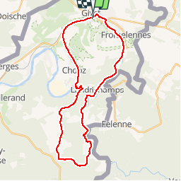
8 km | 9,4 km-effort
2h 0min
![](https://static1.geolcdn.com/siteimages/upload/files/16400158638029165_repeat_loop_refresh_sync_direction_icon.png)
Ja
![Tour Wandern Givet - Promenade sur les remparts du Mont d'Haurs - Photo](https://media.geolcdn.com/t/375/260/ext.jpg?maxdim=2&url=https%3A%2F%2Fservices.sitytrail.com%2FGeolivesWS%2FDownloadMedia.ashx%3FTrailID%3D108905%26Media%3D2570_6.jpg)
![Wandern Wandern](https://static1.geolcdn.com/sitytour/trail-icons/101.png)
Promenade sur les remparts du Mont d'Haurs
Wandern
Medium
(3)
Givet,
Großer Osten,
Ardennes,
France
![](/images/other/stat-length.png)
5,1 km | 6,7 km-effort
2h 0min
![](https://static1.geolcdn.com/siteimages/upload/files/16400158638029165_repeat_loop_refresh_sync_direction_icon.png)
Ja
![Tour Wandern Hastière - Hastiere, Entre mont et vallée - Photo](https://media.geolcdn.com/t/375/260/068d5622-8276-4255-80ea-e863a3df9f37.jpg&format=jpg&maxdim=2)
![Wandern Wandern](https://static1.geolcdn.com/sitytour/trail-icons/101.png)
Hastiere, Entre mont et vallée
Wandern
Medium
(2)
Hastière,
Wallonien,
Namur,
Belgium
![](/images/other/stat-length.png)
11,2 km | 14,3 km-effort
2h 5min
![](https://static1.geolcdn.com/siteimages/upload/files/16400158638029165_repeat_loop_refresh_sync_direction_icon.png)
Ja
![Tour Wandern Rancennes - De Rancennes à Charnois par les Rochers du Petit Chooz - Photo](https://media.geolcdn.com/t/375/260/ext.jpg?maxdim=2&url=https%3A%2F%2Fstatic1.geolcdn.com%2Fsiteimages%2Fupload%2Ffiles%2F1553511878bg_sport_marche.png)
![Wandern Wandern](https://static1.geolcdn.com/sitytour/trail-icons/101.png)
De Rancennes à Charnois par les Rochers du Petit Chooz
Wandern
Einfach
(1)
Rancennes,
Großer Osten,
Ardennes,
France
![](/images/other/stat-length.png)
10,6 km | 14,6 km-effort
2h 30min
![](https://static1.geolcdn.com/siteimages/upload/files/16400158638029165_repeat_loop_refresh_sync_direction_icon.png)
Ja
![Tour Wandern Beauraing - Balade de Dion à Winenne - Beauraing - Photo](https://media.geolcdn.com/t/375/260/5c1dc6e2-7e96-43cd-a912-ceabbaabe8bc.jpeg&format=jpg&maxdim=2)
![Wandern Wandern](https://static1.geolcdn.com/sitytour/trail-icons/101.png)
Balade de Dion à Winenne - Beauraing
Wandern
Medium
(2)
Beauraing,
Wallonien,
Namur,
Belgium
![](/images/other/stat-length.png)
6,5 km | 8,5 km-effort
1h 55min
![](https://static1.geolcdn.com/siteimages/upload/files/16400158638029165_repeat_loop_refresh_sync_direction_icon.png)
Ja
![Tour Wandern Houyet - Marche Adeps à Mesnil-Saint-Blaise - Photo](https://media.geolcdn.com/t/375/260/6e90d8be-93ef-4b26-838b-b9d31637f07d.jpeg&format=jpg&maxdim=2)
![Wandern Wandern](https://static1.geolcdn.com/sitytour/trail-icons/101.png)
Marche Adeps à Mesnil-Saint-Blaise
Wandern
Medium
Houyet,
Wallonien,
Namur,
Belgium
![](/images/other/stat-length.png)
9,8 km | 11,4 km-effort
2h 35min
![](https://static1.geolcdn.com/siteimages/upload/files/16400158638029165_repeat_loop_refresh_sync_direction_icon.png)
Ja
![Tour Wandern Hastière - Promenade 10 - Le Sicou (O.T. Hastière) - Photo](https://media.geolcdn.com/t/375/260/ext.jpg?maxdim=2&url=https%3A%2F%2Fstatic1.geolcdn.com%2Fsiteimages%2Fupload%2Ffiles%2F1553511878bg_sport_marche.png)
![Wandern Wandern](https://static1.geolcdn.com/sitytour/trail-icons/101.png)
Promenade 10 - Le Sicou (O.T. Hastière)
Wandern
Einfach
(2)
Hastière,
Wallonien,
Namur,
Belgium
![](/images/other/stat-length.png)
6,9 km | 9,2 km-effort
1h 57min
![](https://static1.geolcdn.com/siteimages/upload/files/16400158638029165_repeat_loop_refresh_sync_direction_icon.png)
Ja
![Tour Wandern Beauraing - WINENNE ( BEAURAING) _ Marche Fédérales _ NA _ 8/07/2023 - Photo](https://media.geolcdn.com/t/375/260/eb96292b-4717-48a0-89be-098a3bf2f9f3.jpg&format=jpg&maxdim=2)
![Wandern Wandern](https://static1.geolcdn.com/sitytour/trail-icons/101.png)
WINENNE ( BEAURAING) _ Marche Fédérales _ NA _ 8/07/2023
Wandern
Schwierig
Beauraing,
Wallonien,
Namur,
Belgium
![](/images/other/stat-length.png)
20 km | 26 km-effort
4h 45min
![](https://static1.geolcdn.com/siteimages/upload/files/16400158638029165_repeat_loop_refresh_sync_direction_icon.png)
Ja
![Tour Wandern Aubrives - De Aubrives à Aubrives par les bois et l'ancienne carrière - Photo](https://media.geolcdn.com/t/375/260/259fb6d3-d4c7-472a-a1a0-40b99bc710c3.jpg&format=jpg&maxdim=2)
![Wandern Wandern](https://static1.geolcdn.com/sitytour/trail-icons/101.png)
De Aubrives à Aubrives par les bois et l'ancienne carrière
Wandern
Schwierig
Aubrives,
Großer Osten,
Ardennes,
France
![](/images/other/stat-length.png)
14,2 km | 18,7 km-effort
3h 0min
![](https://static1.geolcdn.com/siteimages/upload/files/16400158638029165_repeat_loop_refresh_sync_direction_icon.png)
Ja