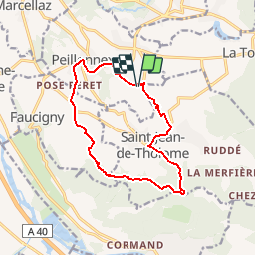
![](/images/other/stat-length.png)
![Tour Mountainbike Peillonnex - Les hauteurs de St Jean de Tholome - Photo](https://media.geolcdn.com/t/1900/400/ext.pjpeg?maxdim=2&url=https%3A%2F%2Fstatic1.geolcdn.com%2Fsiteimages%2Fupload%2Ffiles%2F1524743154velo.jpg)
Les hauteurs de St Jean de Tholome
tracegps
Benutzer
![Länge](/images/other/stat-length.png)
![Maximale Höhe](https://static1.geolcdn.com/siteimages/upload/files/1508320355ic_sort_altitude_max_24dp.png)
![Positive Höhendifferenz](https://static1.geolcdn.com/siteimages/upload/files/1508320355ic_sort_den_pos_24dp.png)
![Km-Effort](/images/other/stat-length.png)
![Min. Höhe](https://static1.geolcdn.com/siteimages/upload/files/1508320355ic_sort_altitude_min_24dp.png)
![Negative Höhendifferenz](https://static1.geolcdn.com/siteimages/upload/files/1508320355ic_sort_den_neg_24dp.png)
![Boucle](https://static1.geolcdn.com/siteimages/upload/files/16400158638029165_repeat_loop_refresh_sync_direction_icon.png)
![Mountainbike](https://static1.geolcdn.com/sitytour/trail-icons/202.png)
1h30
Schwierigkeit : Schwierig
![Scannen Sie diesen QR-Code, um die Tour in der SityTrail-Anwendung zu öffnen](https://capi.geolives.com/qq0zvz2zws4bq2lad0pu/sitytour/trails/105145/qr.png?size=200)
Kostenlosegpshiking-Anwendung
Über SityTrail
Tour Mountainbike von 13,1 km verfügbar auf Auvergne-Rhone-Alpen, Hochsavoyen, Peillonnex. Diese Tour wird von tracegps vorgeschlagen.
Beschreibung
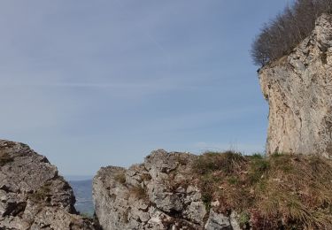
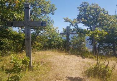
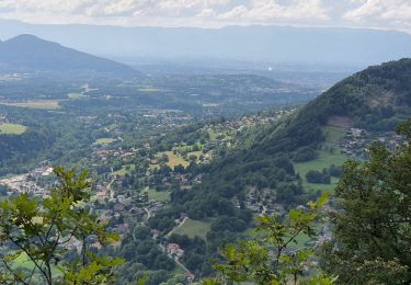
Bonjour à tous, Cette fois il faut aimer les racines et la boue, seulement pour quelques centaines de mètres ceci à partir du col du Réray. Montée par la route et une piste roulante jusqu'au col du Réray, ensuite chemin en forêt et ses gouilles à sanglier au milieu du chemin. Souvent un passage pour les éviter, sinon... Petit coup de rein ensuite jusqu'à la limite du possible, on pousse un peu le vélo. Re-boue, vous l'aurez compris avis aux amateurs, c'est un terrain qui sèche difficilement après même 3 ou 4 jours. Ah enfin ça descend et même assez rapidement sans grand chose de technique ; retour par les prairies. Ah si j'oubliais, étape au bar tabac de Peillo comme on dit par ici. A vos béclous. Luc Thiebaud, AMM qualif vtt. www.vtt-avoriaz.fr
Ort
Kommentare
Touren in der Umgebung
![Tour Wandern La Tour - 17-04-2022 Le tour de Saint Jean de Tholomé - Photo](https://media.geolcdn.com/t/375/260/afe0a2c8-09a9-438d-add3-0f8a286a78fb.jpg&format=jpg&maxdim=2)
![Wandern Wandern](https://static1.geolcdn.com/sitytour/trail-icons/101.png)
Wandern
![](/images/other/stat-length.png)
![](https://static1.geolcdn.com/siteimages/upload/files/16400158638029165_repeat_loop_refresh_sync_direction_icon.png)
![Tour Wandern Viuz-en-Sallaz - Viuz-Les Brasses-Vernant-Viuz - Photo](https://media.geolcdn.com/t/375/260/34dcd57e-15ca-4ca3-ab02-fc2bad27ee19.jpg&format=jpg&maxdim=2)
![Wandern Wandern](https://static1.geolcdn.com/sitytour/trail-icons/101.png)
Wandern
![](/images/other/stat-length.png)
![](https://static1.geolcdn.com/siteimages/upload/files/16400158638029165_repeat_loop_refresh_sync_direction_icon.png)
![Tour Wandern Bonneville - Tour du Reyret - Photo](https://media.geolcdn.com/t/375/260/3a92c894-f22c-4988-83b1-a50c7d0d14a4.jpg&format=jpg&maxdim=2)
![Wandern Wandern](https://static1.geolcdn.com/sitytour/trail-icons/101.png)
Wandern
![](/images/other/stat-length.png)
![](https://static1.geolcdn.com/siteimages/upload/files/16400158638029165_repeat_loop_refresh_sync_direction_icon.png)
![Tour Wandern Ayse - Les Gallinons - Crêtes du Rocher de l'aigle - Les Gallinons - Photo](https://media.geolcdn.com/t/375/260/a639a28d-0ec8-43bc-b5eb-0bc044c3bd96.jpg&format=jpg&maxdim=2)
![Wandern Wandern](https://static1.geolcdn.com/sitytour/trail-icons/101.png)
Wandern
![](/images/other/stat-length.png)
![](https://static1.geolcdn.com/siteimages/upload/files/16400158638029165_repeat_loop_refresh_sync_direction_icon.png)
![Tour Wandern Bonneville - Chemin de Croix d'Orgevat par Le Reyret - Photo](https://media.geolcdn.com/t/375/260/e982347c-b249-4c2e-8b5c-da3bb77412db.jpg&format=jpg&maxdim=2)
![Wandern Wandern](https://static1.geolcdn.com/sitytour/trail-icons/101.png)
Wandern
![](/images/other/stat-length.png)
![](https://static1.geolcdn.com/siteimages/upload/files/16400158638029165_repeat_loop_refresh_sync_direction_icon.png)
![Tour Wandern Ville-en-Sallaz - 2020-07 Lac du Môle - Saint Jeoire - Photo](https://media.geolcdn.com/t/375/260/4ade7828-b272-4802-b721-df9a5ba1cac5.jpg&format=jpg&maxdim=2)
![Wandern Wandern](https://static1.geolcdn.com/sitytour/trail-icons/101.png)
Wandern
![](/images/other/stat-length.png)
![](https://static1.geolcdn.com/siteimages/upload/files/16400158638029165_repeat_loop_refresh_sync_direction_icon.png)
![Tour Mountainbike Peillonnex - Crêtes de Vouan Ludran descente Foron de Viuz - Photo](https://media.geolcdn.com/t/375/260/ext.jpg?maxdim=2&url=https%3A%2F%2Fstatic1.geolcdn.com%2Fsiteimages%2Fupload%2Ffiles%2F1524743154velo.jpg)
![Mountainbike Mountainbike](https://static1.geolcdn.com/sitytour/trail-icons/202.png)
Mountainbike
![](/images/other/stat-length.png)
![](https://static1.geolcdn.com/siteimages/upload/files/16400158638029165_repeat_loop_refresh_sync_direction_icon.png)
![Tour Laufen Saint-Jean-de-Tholome - Sortie Longue GR1 - 17/04 - Photo](https://media.geolcdn.com/t/375/260/ext.jpg?maxdim=2&url=https%3A%2F%2Fstatic1.geolcdn.com%2Fsiteimages%2Fupload%2Ffiles%2F1524743154running.jpg)
![Laufen Laufen](https://static1.geolcdn.com/sitytour/trail-icons/103.png)
Laufen
![](/images/other/stat-length.png)
![](https://static1.geolcdn.com/siteimages/upload/files/16400158638029165_repeat_loop_refresh_sync_direction_icon.png)
![Tour Wandern Viuz-en-Sallaz - Boisinges - Crêtes de Vouan_25.07.2021 - Photo](https://media.geolcdn.com/t/375/260/63e31eaa-4938-4cc2-88e4-e3de10ed1069.jpg&format=jpg&maxdim=2)
![Wandern Wandern](https://static1.geolcdn.com/sitytour/trail-icons/101.png)
Wandern
![](/images/other/stat-length.png)
![](https://static1.geolcdn.com/siteimages/upload/files/16400158638029165_repeat_loop_refresh_sync_direction_icon.png)