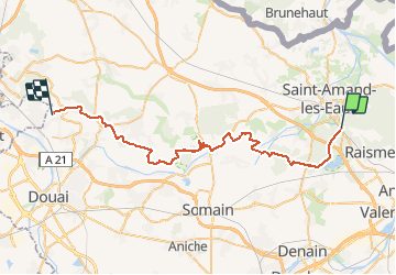
![](/images/other/stat-length.png)
![Tour Wandern Saint-Amand-les-Eaux - Saint Amand les Eaux - Raimbeaucourt - rando sur 2 jours - Photo](https://media.geolcdn.com/t/1900/400/ext.pjpeg?maxdim=2&url=https%3A%2F%2Fservices.sitytrail.com%2FGeolivesWS%2FDownloadMedia.ashx%3FTrailID%3D105133%26Media%3D8743_3.jpg)
Saint Amand les Eaux - Raimbeaucourt - rando sur 2 jours
tracegps
Benutzer
![Länge](/images/other/stat-length.png)
![Maximale Höhe](https://static1.geolcdn.com/siteimages/upload/files/1508320355ic_sort_altitude_max_24dp.png)
![Positive Höhendifferenz](https://static1.geolcdn.com/siteimages/upload/files/1508320355ic_sort_den_pos_24dp.png)
![Km-Effort](/images/other/stat-length.png)
![Min. Höhe](https://static1.geolcdn.com/siteimages/upload/files/1508320355ic_sort_altitude_min_24dp.png)
![Negative Höhendifferenz](https://static1.geolcdn.com/siteimages/upload/files/1508320355ic_sort_den_neg_24dp.png)
![Boucle](https://static1.geolcdn.com/siteimages/upload/files/16400158638029165_repeat_loop_refresh_sync_direction_icon.png)
![Wandern](https://static1.geolcdn.com/sitytour/trail-icons/101.png)
10h00
Schwierigkeit : Schwierig
![Scannen Sie diesen QR-Code, um die Tour in der SityTrail-Anwendung zu öffnen](https://capi.geolives.com/qq0zvz2zws4bq2lad0pu/sitytour/trails/105133/qr.png?size=200)
Kostenlosegpshiking-Anwendung
Über SityTrail
Tour Wandern von 43 km verfügbar auf Nordfrankreich, Nord, Saint-Amand-les-Eaux. Diese Tour wird von tracegps vorgeschlagen.
Beschreibung
GR 121 Saint Amand les eaux GR 121b Raimbeaucourt: Randonnée en 2jours en autonomie complète. Prévoir un retour. Départ au lieu dit La Grise Chemise à St Amand les Eaux. Jour 1: suivre le GR 121 jusque Marchiennes 22 km. Jour2 Suivre le GR 121B jusque Raimbeaucourt 22km. Bivouac au camping des Evoiches à Marchiennes. A Marchiennes voir les vestiges de l'ancienne Abbaye Bénédictine. Toute les Photos et carnet de Randonnée sur www.nord-gr-randotrek.fr ou ICI. Merci pour votre visite.
Ort
Kommentare
Touren in der Umgebung
![Tour Wandern Raismes - Circuit du Terril de Sabatier - Photo](https://media.geolcdn.com/t/375/260/ext.jpg?maxdim=2&url=https%3A%2F%2Fservices.sitytrail.com%2FGeolivesWS%2FDownloadMedia.ashx%3FTrailID%3D479716%26Media%3D781031eb-7ab3-4c80-8a0c-0836d5a81ce2.JPG)
![Wandern Wandern](https://static1.geolcdn.com/sitytour/trail-icons/101.png)
Wandern
![](/images/other/stat-length.png)
![](https://static1.geolcdn.com/siteimages/upload/files/16400158638029165_repeat_loop_refresh_sync_direction_icon.png)
![Tour Wandern Wallers - Mare à Goriau - Photo](https://media.geolcdn.com/t/375/260/299e6191-18b5-438f-9d95-49f66a90f690.jpg&format=jpg&maxdim=2)
![Wandern Wandern](https://static1.geolcdn.com/sitytour/trail-icons/101.png)
Wandern
![](/images/other/stat-length.png)
![](https://static1.geolcdn.com/siteimages/upload/files/16400158638029165_repeat_loop_refresh_sync_direction_icon.png)
![Tour Wandern Raismes - Mare à Goriaux - Photo](https://media.geolcdn.com/t/375/260/cb4184f6-3666-47fb-a89a-0644abab2b32.jpg&format=jpg&maxdim=2)
![Wandern Wandern](https://static1.geolcdn.com/sitytour/trail-icons/101.png)
Wandern
![](/images/other/stat-length.png)
![](https://static1.geolcdn.com/siteimages/upload/files/16400158638029165_repeat_loop_refresh_sync_direction_icon.png)
![Tour Wandern Saint-Amand-les-Eaux - terril vicoigne - Photo](https://media.geolcdn.com/t/375/260/d8552856-5959-4bc8-a6d2-93f721ca17ec.jpg&format=jpg&maxdim=2)
![Wandern Wandern](https://static1.geolcdn.com/sitytour/trail-icons/101.png)
Wandern
![](/images/other/stat-length.png)
![](https://static1.geolcdn.com/siteimages/upload/files/16400158638029165_repeat_loop_refresh_sync_direction_icon.png)
![Tour Wandern Saint-Amand-les-Eaux - notre dame d'amour(NDA), propose par VDN - Photo](https://media.geolcdn.com/t/375/260/630cd120-0ef0-4a83-86e7-91e6331d9f35.jpg&format=jpg&maxdim=2)
![Wandern Wandern](https://static1.geolcdn.com/sitytour/trail-icons/101.png)
Wandern
![](/images/other/stat-length.png)
![](https://static1.geolcdn.com/siteimages/upload/files/16400158638029165_repeat_loop_refresh_sync_direction_icon.png)
![Tour Wandern Raismes - variante de la course des terrils - Photo](https://media.geolcdn.com/t/375/260/f1af6116-6469-445b-a358-4f5a4f22ced7.jpg&format=jpg&maxdim=2)
![Wandern Wandern](https://static1.geolcdn.com/sitytour/trail-icons/101.png)
Wandern
![](/images/other/stat-length.png)
![](https://static1.geolcdn.com/siteimages/upload/files/16400158638029165_repeat_loop_refresh_sync_direction_icon.png)
![Tour Wandern Wallers - Mare goraux - Photo](https://media.geolcdn.com/t/375/260/82eaa7c8-ae6a-4094-92a3-48d31e49731d.jpg&format=jpg&maxdim=2)
![Wandern Wandern](https://static1.geolcdn.com/sitytour/trail-icons/101.png)
![Tour Wandern Nivelle - Nivelle- circuit Nivelle-Mortagne-Chateau l'abbaye - Photo](https://media.geolcdn.com/t/375/260/d91e613a-8448-41fc-bfd3-8fd05bd73b48.jpg&format=jpg&maxdim=2)
![Wandern Wandern](https://static1.geolcdn.com/sitytour/trail-icons/101.png)
Wandern
![](/images/other/stat-length.png)
![](https://static1.geolcdn.com/siteimages/upload/files/16400158638029165_repeat_loop_refresh_sync_direction_icon.png)
![Tour Wandern Wallers - tour d'Hasnon par forêt et ruisseau - Photo](https://media.geolcdn.com/t/375/260/2b9bf806-1bf3-4e60-9b73-d4a339f79ca9.jpg&format=jpg&maxdim=2)
![Wandern Wandern](https://static1.geolcdn.com/sitytour/trail-icons/101.png)
Wandern
![](/images/other/stat-length.png)
![](https://static1.geolcdn.com/siteimages/upload/files/16400158638029165_repeat_loop_refresh_sync_direction_icon.png)
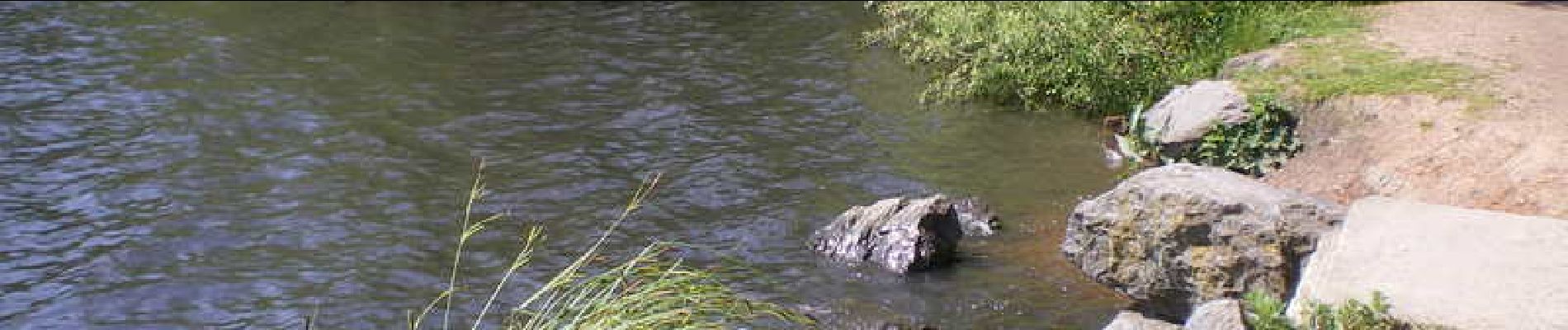
rando sympa mais camping très bruyant de nuit