![](/images/other/stat-length.png)
![Tour Wandern Rodès - 20181001 autour de Rodés - Photo](https://media.geolcdn.com/t/1900/400/ext.pjpeg?maxdim=2&url=https%3A%2F%2Fservices.sitytrail.com%2FGeolivesWS%2FDownloadMedia.ashx%3FTrailID%3D1050143%26Media%3D20181002131948.jpg)
20181001 autour de Rodés
ThonyM
Benutzer
![Länge](/images/other/stat-length.png)
Länge
17,1 km
![Maximale Höhe](https://static1.geolcdn.com/siteimages/upload/files/1508320355ic_sort_altitude_max_24dp.png)
Maximale Höhe
358 m
![Positive Höhendifferenz](https://static1.geolcdn.com/siteimages/upload/files/1508320355ic_sort_den_pos_24dp.png)
Positive Höhendifferenz
447 m
![Km-Effort](/images/other/stat-length.png)
Km-Effort
23 km
![Min. Höhe](https://static1.geolcdn.com/siteimages/upload/files/1508320355ic_sort_altitude_min_24dp.png)
Min. Höhe
137 m
![Negative Höhendifferenz](https://static1.geolcdn.com/siteimages/upload/files/1508320355ic_sort_den_neg_24dp.png)
Negative Höhendifferenz
447 m
![Boucle](https://static1.geolcdn.com/siteimages/upload/files/16400158638029165_repeat_loop_refresh_sync_direction_icon.png)
Boucle
Ja
Erstellungsdatum :
2019-01-15 17:08:33.109
Letzte Änderung :
2019-01-15 17:08:33.109
![Wandern](https://static1.geolcdn.com/sitytour/trail-icons/101.png)
4h15
Schwierigkeit : Medium
![Scannen Sie diesen QR-Code, um die Tour in der SityTrail-Anwendung zu öffnen](https://capi.geolives.com/qq0zvz2zws4bq2lad0pu/sitytour/trails/1050143/qr.png?size=200)
Kostenlosegpshiking-Anwendung
Über SityTrail
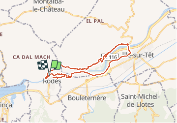
Tour Wandern von 17,1 km verfügbar auf Okzitanien, Ostpyrenäen, Rodès. Diese Tour wird von ThonyM vorgeschlagen.
Beschreibung
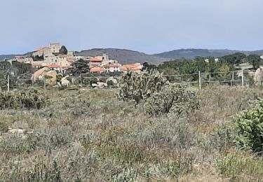
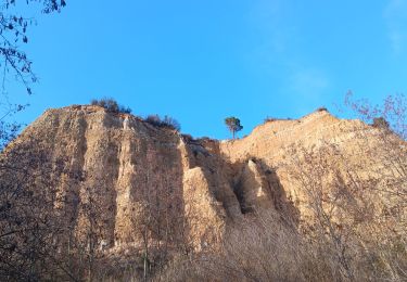
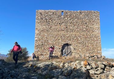
Tres beau parcours le long du canal, jusqu'au château en ruines. Un petit détour par Illes pour fermer la boucle sur la rive opposée. Les gorges de la Guillera méritent d'être vues
Ort
Land:
France
Region :
Okzitanien
Abteilung/Provinz :
Ostpyrenäen
Kommune :
Rodès
Standort:
Unknown
Gehen Sie:(Dec)
Gehen Sie:(UTM)
463995 ; 4723136 (31T) N.
Kommentare
Touren in der Umgebung
![Tour Wandern Ille-sur-Têt - ILLE TÊT 66 - PIC PEDROUS - CASESNOVES - Photo](https://media.geolcdn.com/t/375/260/ext.jpg?maxdim=2&url=https%3A%2F%2Fstatic1.geolcdn.com%2Fsiteimages%2Fupload%2Ffiles%2F1553511878bg_sport_marche.png)
![Wandern Wandern](https://static1.geolcdn.com/sitytour/trail-icons/101.png)
ILLE TÊT 66 - PIC PEDROUS - CASESNOVES
Wandern
Medium
(10)
Ille-sur-Têt,
Okzitanien,
Ostpyrenäen,
France
![](/images/other/stat-length.png)
11 km | 15,3 km-effort
2h 22min
![](https://static1.geolcdn.com/siteimages/upload/files/16400158638029165_repeat_loop_refresh_sync_direction_icon.png)
Ja
![Tour Mountainbike Vinça - parcours ronde de Sahorle 2013 - Photo](https://media.geolcdn.com/t/375/260/ext.jpg?maxdim=2&url=https%3A%2F%2Fstatic1.geolcdn.com%2Fsiteimages%2Fupload%2Ffiles%2F1524743154velo.jpg)
![Mountainbike Mountainbike](https://static1.geolcdn.com/sitytour/trail-icons/202.png)
parcours ronde de Sahorle 2013
Mountainbike
Medium
(1)
Vinça,
Okzitanien,
Ostpyrenäen,
France
![](/images/other/stat-length.png)
17 km | 22 km-effort
1h 27min
![](https://static1.geolcdn.com/siteimages/upload/files/16400158638029165_repeat_loop_refresh_sync_direction_icon.png)
Ja
![Tour Wandern Casefabre - Casefabre 66 - Photo](https://media.geolcdn.com/t/375/260/fda5b463-42b5-4e8b-9ebd-458b38a5ec57.jpg&format=jpg&maxdim=2)
![Wandern Wandern](https://static1.geolcdn.com/sitytour/trail-icons/101.png)
Casefabre 66
Wandern
Medium
Casefabre,
Okzitanien,
Ostpyrenäen,
France
![](/images/other/stat-length.png)
10,4 km | 14,8 km-effort
3h 19min
![](https://static1.geolcdn.com/siteimages/upload/files/16400158638029165_repeat_loop_refresh_sync_direction_icon.png)
Ja
![Tour sport Finestret - 20250109 petite boucle depuis Finestret - Photo](https://media.geolcdn.com/t/375/260/e154baa2-7741-43ff-8fd2-a9135305a5c2.jpg&format=jpg&maxdim=2)
20250109 petite boucle depuis Finestret
sport
Sehr leicht
Finestret,
Okzitanien,
Ostpyrenäen,
France
![](/images/other/stat-length.png)
10,1 km | 16,5 km-effort
Unbekannt
![](https://static1.geolcdn.com/siteimages/upload/files/16400158638029165_repeat_loop_refresh_sync_direction_icon.png)
Ja
![Tour Wandern Montalba-le-Château - Montauban le château corral grandes or - Photo](https://media.geolcdn.com/t/375/260/4e0c3970-675f-4ac8-9536-c3e289d07d9a.jpg&format=jpg&maxdim=2)
![Wandern Wandern](https://static1.geolcdn.com/sitytour/trail-icons/101.png)
Montauban le château corral grandes or
Wandern
Schwierig
Montalba-le-Château,
Okzitanien,
Ostpyrenäen,
France
![](/images/other/stat-length.png)
12,9 km | 16,3 km-effort
3h 42min
![](https://static1.geolcdn.com/siteimages/upload/files/16400158638029165_repeat_loop_refresh_sync_direction_icon.png)
Ja
![Tour Wandern Ille-sur-Têt - puig pedros - Photo](https://media.geolcdn.com/t/375/260/6e0829b7-bca5-48a1-8515-e2b45ee19f4d.jpg&format=jpg&maxdim=2)
![Wandern Wandern](https://static1.geolcdn.com/sitytour/trail-icons/101.png)
puig pedros
Wandern
Medium
Ille-sur-Têt,
Okzitanien,
Ostpyrenäen,
France
![](/images/other/stat-length.png)
11,7 km | 15,6 km-effort
3h 57min
![](https://static1.geolcdn.com/siteimages/upload/files/16400158638029165_repeat_loop_refresh_sync_direction_icon.png)
Ja
![Tour Wandern Arboussols - Marcevol - Photo](https://media.geolcdn.com/t/375/260/c36f51d8-a44d-419f-a023-7a6ff9003ad5.jpg&format=jpg&maxdim=2)
![Wandern Wandern](https://static1.geolcdn.com/sitytour/trail-icons/101.png)
Marcevol
Wandern
Sehr schwierig
Arboussols,
Okzitanien,
Ostpyrenäen,
France
![](/images/other/stat-length.png)
15,9 km | 23 km-effort
6h 58min
![](https://static1.geolcdn.com/siteimages/upload/files/16400158638029165_repeat_loop_refresh_sync_direction_icon.png)
Ja
![Tour Wandern Tarerach - Tarerach - Photo](https://media.geolcdn.com/t/375/260/ac55caa1-a948-4bf7-87aa-6f2d79de33ca.jpg&format=jpg&maxdim=2)
![Wandern Wandern](https://static1.geolcdn.com/sitytour/trail-icons/101.png)
Tarerach
Wandern
Schwierig
Tarerach,
Okzitanien,
Ostpyrenäen,
France
![](/images/other/stat-length.png)
12 km | 16,2 km-effort
3h 19min
![](https://static1.geolcdn.com/siteimages/upload/files/16400158638029165_repeat_loop_refresh_sync_direction_icon.png)
Ja
![Tour Wandern Montalba-le-Château - montant a - Photo](https://media.geolcdn.com/t/375/260/bab4a258-ec8b-477d-a8cf-388a6f2cb82a.jpg&format=jpg&maxdim=2)
![Wandern Wandern](https://static1.geolcdn.com/sitytour/trail-icons/101.png)
montant a
Wandern
Schwierig
Montalba-le-Château,
Okzitanien,
Ostpyrenäen,
France
![](/images/other/stat-length.png)
11,8 km | 14,7 km-effort
5h 2min
![](https://static1.geolcdn.com/siteimages/upload/files/16400158638029165_repeat_loop_refresh_sync_direction_icon.png)
Nein