![](/images/other/stat-length.png)
![Tour Wandern Saint-Césaire - Les 7 sources Saint Bris des Bois - Photo](https://media.geolcdn.com/t/1900/400/ext.pjpeg?maxdim=2&url=https%3A%2F%2Fservices.sitytrail.com%2FGeolivesWS%2FDownloadMedia.ashx%3FTrailID%3D104847%26Media%3D8351_1.jpg)
Les 7 sources Saint Bris des Bois
tracegps
Benutzer
![Länge](/images/other/stat-length.png)
Länge
14,4 km
![Maximale Höhe](https://static1.geolcdn.com/siteimages/upload/files/1508320355ic_sort_altitude_max_24dp.png)
Maximale Höhe
84 m
![Positive Höhendifferenz](https://static1.geolcdn.com/siteimages/upload/files/1508320355ic_sort_den_pos_24dp.png)
Positive Höhendifferenz
214 m
![Km-Effort](/images/other/stat-length.png)
Km-Effort
17,3 km
![Min. Höhe](https://static1.geolcdn.com/siteimages/upload/files/1508320355ic_sort_altitude_min_24dp.png)
Min. Höhe
38 m
![Negative Höhendifferenz](https://static1.geolcdn.com/siteimages/upload/files/1508320355ic_sort_den_neg_24dp.png)
Negative Höhendifferenz
215 m
![Boucle](https://static1.geolcdn.com/siteimages/upload/files/16400158638029165_repeat_loop_refresh_sync_direction_icon.png)
Boucle
Ja
Erstellungsdatum :
2014-12-10 00:00:00.0
Letzte Änderung :
2014-12-10 00:00:00.0
![Wandern](https://static1.geolcdn.com/sitytour/trail-icons/101.png)
3h30
Schwierigkeit : Schwierig
![Scannen Sie diesen QR-Code, um die Tour in der SityTrail-Anwendung zu öffnen](https://capi.geolives.com/qq0zvz2zws4bq2lad0pu/sitytour/trails/104847/qr.png?size=200)
Kostenlosegpshiking-Anwendung
Über SityTrail
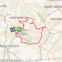
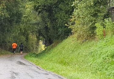
Tour Wandern von 14,4 km verfügbar auf Neu-Aquitanien, Charente-Maritime, Saint-Césaire. Diese Tour wird von tracegps vorgeschlagen.
Beschreibung
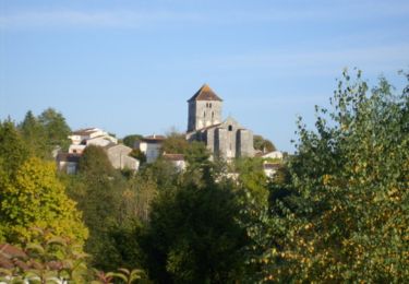
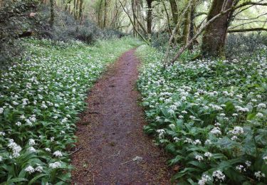
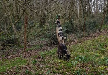
Belle boucle dans la campagne charentaise, passant par 7 sources et lavoirs, avec une vue sympathique de l'abbaye de Fontdouce.
Ort
Land:
France
Region :
Neu-Aquitanien
Abteilung/Provinz :
Charente-Maritime
Kommune :
Saint-Césaire
Standort:
Unknown
Gehen Sie:(Dec)
Gehen Sie:(UTM)
694705 ; 5070893 (30T) N.
Kommentare
Touren in der Umgebung
![Tour Pferd La Chapelle-des-Pots - Circuit des potiers - La Chapelle des Pots - Photo](https://media.geolcdn.com/t/375/260/ext.jpg?maxdim=2&url=https%3A%2F%2Fservices.sitytrail.com%2FGeolivesWS%2FDownloadMedia.ashx%3FTrailID%3D112268%26Media%3D10265_6.jpg)
![Pferd Pferd](https://static1.geolcdn.com/sitytour/trail-icons/300.png)
Circuit des potiers - La Chapelle des Pots
Pferd
Einfach
(1)
La Chapelle-des-Pots,
Neu-Aquitanien,
Charente-Maritime,
France
![](/images/other/stat-length.png)
7,2 km | 8,5 km-effort
1h 19min
![](https://static1.geolcdn.com/siteimages/upload/files/16400158638029165_repeat_loop_refresh_sync_direction_icon.png)
Ja
![Tour Wandern La Chapelle-des-Pots - la Chapelle des Pots ( D ROUSSET) - Photo](https://media.geolcdn.com/t/375/260/ext.jpg?maxdim=2&url=https%3A%2F%2Fstatic1.geolcdn.com%2Fsiteimages%2Fupload%2Ffiles%2F1553511878bg_sport_marche.png)
![Wandern Wandern](https://static1.geolcdn.com/sitytour/trail-icons/101.png)
la Chapelle des Pots ( D ROUSSET)
Wandern
Medium
(1)
La Chapelle-des-Pots,
Neu-Aquitanien,
Charente-Maritime,
France
![](/images/other/stat-length.png)
7,8 km | 8,8 km-effort
2h 40min
![](https://static1.geolcdn.com/siteimages/upload/files/16400158638029165_repeat_loop_refresh_sync_direction_icon.png)
Ja
![Tour Wandern La Chapelle-des-Pots - La Chapelle des Pots - Asphodèles - Photo](https://media.geolcdn.com/t/375/260/ext.jpg?maxdim=2&url=https%3A%2F%2Fstatic1.geolcdn.com%2Fsiteimages%2Fupload%2Ffiles%2F1553511878bg_sport_marche.png)
![Wandern Wandern](https://static1.geolcdn.com/sitytour/trail-icons/101.png)
La Chapelle des Pots - Asphodèles
Wandern
Einfach
(1)
La Chapelle-des-Pots,
Neu-Aquitanien,
Charente-Maritime,
France
![](/images/other/stat-length.png)
7,4 km | 8,7 km-effort
2h 5min
![](https://static1.geolcdn.com/siteimages/upload/files/16400158638029165_repeat_loop_refresh_sync_direction_icon.png)
Ja
![Tour Mountainbike La Chapelle-des-Pots - Circuit des potiers - La Chapelle des Pots - Photo](https://media.geolcdn.com/t/375/260/ext.jpg?maxdim=2&url=https%3A%2F%2Fservices.sitytrail.com%2FGeolivesWS%2FDownloadMedia.ashx%3FTrailID%3D112267%26Media%3D10265_6.jpg)
![Mountainbike Mountainbike](https://static1.geolcdn.com/sitytour/trail-icons/202.png)
Circuit des potiers - La Chapelle des Pots
Mountainbike
Einfach
La Chapelle-des-Pots,
Neu-Aquitanien,
Charente-Maritime,
France
![](/images/other/stat-length.png)
7,2 km | 8,5 km-effort
34min
![](https://static1.geolcdn.com/siteimages/upload/files/16400158638029165_repeat_loop_refresh_sync_direction_icon.png)
Ja
![Tour Wandern La Chapelle-des-Pots - Circuit des potiers - La Chapelle des Pots - Photo](https://media.geolcdn.com/t/375/260/ext.jpg?maxdim=2&url=https%3A%2F%2Fservices.sitytrail.com%2FGeolivesWS%2FDownloadMedia.ashx%3FTrailID%3D112266%26Media%3D10265_6.jpg)
![Wandern Wandern](https://static1.geolcdn.com/sitytour/trail-icons/101.png)
Circuit des potiers - La Chapelle des Pots
Wandern
Medium
La Chapelle-des-Pots,
Neu-Aquitanien,
Charente-Maritime,
France
![](/images/other/stat-length.png)
7,2 km | 8,5 km-effort
2h 0min
![](https://static1.geolcdn.com/siteimages/upload/files/16400158638029165_repeat_loop_refresh_sync_direction_icon.png)
Ja
![Tour Wandern Saint-Césaire - La Vallée du Coran - St Bris des Bois - Photo](https://media.geolcdn.com/t/375/260/ext.jpg?maxdim=2&url=https%3A%2F%2Fservices.sitytrail.com%2FGeolivesWS%2FDownloadMedia.ashx%3FTrailID%3D104819%26Media%3D8309_3.jpg)
![Wandern Wandern](https://static1.geolcdn.com/sitytour/trail-icons/101.png)
La Vallée du Coran - St Bris des Bois
Wandern
Medium
Saint-Césaire,
Neu-Aquitanien,
Charente-Maritime,
France
![](/images/other/stat-length.png)
7,4 km | 8,9 km-effort
2h 0min
![](https://static1.geolcdn.com/siteimages/upload/files/16400158638029165_repeat_loop_refresh_sync_direction_icon.png)
Ja
![Tour Wandern Vénérand - venerand - Photo](https://media.geolcdn.com/t/375/260/0a164881-874a-433b-bd04-75760cc4c84f.jpg&format=jpg&maxdim=2)
![Wandern Wandern](https://static1.geolcdn.com/sitytour/trail-icons/101.png)
venerand
Wandern
Sehr schwierig
Vénérand,
Neu-Aquitanien,
Charente-Maritime,
France
![](/images/other/stat-length.png)
24 km | 28 km-effort
6h 21min
![](https://static1.geolcdn.com/siteimages/upload/files/16400158638029165_repeat_loop_refresh_sync_direction_icon.png)
Nein
![Tour Wandern La Chapelle-des-Pots - la chapelle des pots - Photo](https://media.geolcdn.com/t/375/260/b1eedf2a-f1d4-49f5-bb3b-003c73982131.jpg&format=jpg&maxdim=2)
![Wandern Wandern](https://static1.geolcdn.com/sitytour/trail-icons/101.png)
la chapelle des pots
Wandern
Medium
La Chapelle-des-Pots,
Neu-Aquitanien,
Charente-Maritime,
France
![](/images/other/stat-length.png)
5,9 km | 7,1 km-effort
2h 2min
![](https://static1.geolcdn.com/siteimages/upload/files/16400158638029165_repeat_loop_refresh_sync_direction_icon.png)
Ja
![Tour Laufen Villars-les-Bois - Course de côtes - Photo](https://media.geolcdn.com/t/375/260/3ea6d005-f62d-4302-b079-e15c07eaa5ce.jpg&format=jpg&maxdim=2)
![Laufen Laufen](https://static1.geolcdn.com/sitytour/trail-icons/103.png)
Course de côtes
Laufen
Schwierig
Villars-les-Bois,
Neu-Aquitanien,
Charente-Maritime,
France
![](/images/other/stat-length.png)
15,1 km | 19,2 km-effort
Unbekannt
![](https://static1.geolcdn.com/siteimages/upload/files/16400158638029165_repeat_loop_refresh_sync_direction_icon.png)
Ja