![](/images/other/stat-length.png)
![Tour Wandern Appy - Etang et col d'Appy - Photo](https://media.geolcdn.com/t/1900/400/ext.pjpeg?maxdim=2&url=https%3A%2F%2Fservices.sitytrail.com%2FGeolivesWS%2FDownloadMedia.ashx%3FTrailID%3D104792%26Media%3D8262_2.jpg)
Etang et col d'Appy
tracegps
Benutzer
![Länge](/images/other/stat-length.png)
![Maximale Höhe](https://static1.geolcdn.com/siteimages/upload/files/1508320355ic_sort_altitude_max_24dp.png)
![Positive Höhendifferenz](https://static1.geolcdn.com/siteimages/upload/files/1508320355ic_sort_den_pos_24dp.png)
![Km-Effort](/images/other/stat-length.png)
![Min. Höhe](https://static1.geolcdn.com/siteimages/upload/files/1508320355ic_sort_altitude_min_24dp.png)
![Negative Höhendifferenz](https://static1.geolcdn.com/siteimages/upload/files/1508320355ic_sort_den_neg_24dp.png)
![Boucle](https://static1.geolcdn.com/siteimages/upload/files/16400158638029165_repeat_loop_refresh_sync_direction_icon.png)
![Wandern](https://static1.geolcdn.com/sitytour/trail-icons/101.png)
4h00
Schwierigkeit : Medium
![Scannen Sie diesen QR-Code, um die Tour in der SityTrail-Anwendung zu öffnen](https://capi.geolives.com/qq0zvz2zws4bq2lad0pu/sitytour/trails/104792/qr.png?size=200)
Kostenlosegpshiking-Anwendung
Über SityTrail
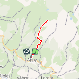
Tour Wandern von 10,5 km verfügbar auf Okzitanien, Ariège, Appy. Diese Tour wird von tracegps vorgeschlagen.
Beschreibung
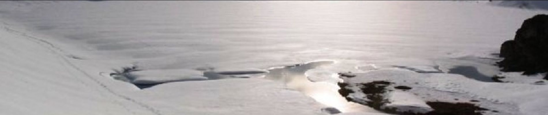
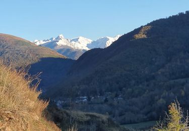
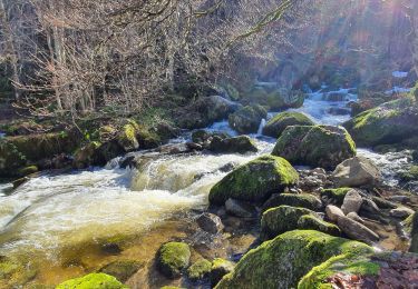
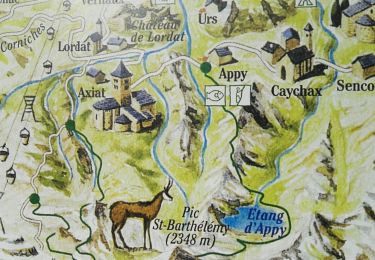
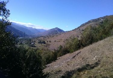
Sur le versant sud du massif de Tabe dominé par le pic Saint Barthélémy (2348m d’altitude), le bel étang d’Appy, réputé poissonneux, est l’occasion d’une randonnée facile de plus de 750m de dénivelé positif. Depuis “ la Corniche ”, plateau suspendu à 1000m d’altitude, vous verrez, au fur et à mesure de cette ascension, se dessiner les sommets frontaliers du massif de l’Aston. Soleil, chaleur et panorama seront vos complices durant toute cette bien jolie randonnée au départ du village d’Appy. (source Comité Départemental du Tourisme de l'Ariège)
Ort
Kommentare
Touren in der Umgebung
![Tour Wandern Vèbre - rocher de Courbas - Photo](https://media.geolcdn.com/t/375/260/78ac6878-cdb8-4ec7-b32a-125e834666e2.jpg&format=jpg&maxdim=2)
![Wandern Wandern](https://static1.geolcdn.com/sitytour/trail-icons/101.png)
Wandern
![](/images/other/stat-length.png)
![](https://static1.geolcdn.com/siteimages/upload/files/16400158638029165_repeat_loop_refresh_sync_direction_icon.png)
![Tour Wandern Garanou - Camina De Luzenac à Ax les thermes - Photo](https://media.geolcdn.com/t/375/260/3bc37f44-7055-4b43-adbc-7a36afdb8cab.jpg&format=jpg&maxdim=2)
![Wandern Wandern](https://static1.geolcdn.com/sitytour/trail-icons/101.png)
Wandern
![](/images/other/stat-length.png)
![](https://static1.geolcdn.com/siteimages/upload/files/16400158638029165_repeat_loop_refresh_sync_direction_icon.png)
![Tour Wandern Luzenac - cabane coumels - Photo](https://media.geolcdn.com/t/375/260/5e22dc37-96f9-490d-94d3-4b0d5f0aba2b.jpg&format=jpg&maxdim=2)
![Wandern Wandern](https://static1.geolcdn.com/sitytour/trail-icons/101.png)
Wandern
![](/images/other/stat-length.png)
![](https://static1.geolcdn.com/siteimages/upload/files/16400158638029165_repeat_loop_refresh_sync_direction_icon.png)
![Tour Wandern Verdun - Verdun, Albies, Vebre - Photo](https://media.geolcdn.com/t/375/260/09d31640-9aa3-44e2-9378-d3fce780c5e7.jpg&format=jpg&maxdim=2)
![Wandern Wandern](https://static1.geolcdn.com/sitytour/trail-icons/101.png)
Wandern
![](/images/other/stat-length.png)
![](https://static1.geolcdn.com/siteimages/upload/files/16400158638029165_repeat_loop_refresh_sync_direction_icon.png)
![Tour Wandern Vèbre - Vebre, Lassure, La Remise, Vebre - Photo](https://media.geolcdn.com/t/375/260/cf162537-37a8-4720-813f-495781f6b81b.jpg&format=jpg&maxdim=2)
![Wandern Wandern](https://static1.geolcdn.com/sitytour/trail-icons/101.png)
Wandern
![](/images/other/stat-length.png)
![](https://static1.geolcdn.com/siteimages/upload/files/16400158638029165_repeat_loop_refresh_sync_direction_icon.png)
![Tour Wandern Vèbre - Vebre, Caychax. Alliés, Vebre - Photo](https://media.geolcdn.com/t/375/260/f0774cf6-f888-497f-b6e0-9780e9ab44f4.jpg&format=jpg&maxdim=2)
![Wandern Wandern](https://static1.geolcdn.com/sitytour/trail-icons/101.png)
Wandern
![](/images/other/stat-length.png)
![](https://static1.geolcdn.com/siteimages/upload/files/16400158638029165_repeat_loop_refresh_sync_direction_icon.png)
![Tour Wandern Unac - Vallée de Caussou - Photo](https://media.geolcdn.com/t/375/260/ext.jpg?maxdim=2&url=https%3A%2F%2Fservices.sitytrail.com%2FGeolivesWS%2FDownloadMedia.ashx%3FTrailID%3D642964%26Media%3Dfix__20161008153717.jpg)
![Wandern Wandern](https://static1.geolcdn.com/sitytour/trail-icons/101.png)
Wandern
![](/images/other/stat-length.png)
![](https://static1.geolcdn.com/siteimages/upload/files/16400158638029165_repeat_loop_refresh_sync_direction_icon.png)
![Tour Wandern Lordat - Le tour du rocher du Courbas - Photo](https://media.geolcdn.com/t/375/260/232cfd43-5ea0-4abb-9fbc-7d823bef0df4.jpg&format=jpg&maxdim=2)
![Wandern Wandern](https://static1.geolcdn.com/sitytour/trail-icons/101.png)
Wandern
![](/images/other/stat-length.png)
![](https://static1.geolcdn.com/siteimages/upload/files/16400158638029165_repeat_loop_refresh_sync_direction_icon.png)
![Tour Wandern Les Cabannes - Camina des Cabannes à Luzenac - Photo](https://media.geolcdn.com/t/375/260/769278fe-4b2d-46e7-8dc9-a102db4840ed.jpg&format=jpg&maxdim=2)
![Wandern Wandern](https://static1.geolcdn.com/sitytour/trail-icons/101.png)
Wandern
![](/images/other/stat-length.png)
![](https://static1.geolcdn.com/siteimages/upload/files/16400158638029165_repeat_loop_refresh_sync_direction_icon.png)