![](/images/other/stat-length.png)
![Tour Mountainbike Gars - Grande Traversée des PréAlpes à VTT : Gars - Aiglun - Photo](https://media.geolcdn.com/t/1900/400/ext.pjpeg?maxdim=2&url=https%3A%2F%2Fservices.sitytrail.com%2FGeolivesWS%2FDownloadMedia.ashx%3FTrailID%3D104787%26Media%3D8254_1.jpg)
Grande Traversée des PréAlpes à VTT : Gars - Aiglun
tracegps
Benutzer
![Länge](/images/other/stat-length.png)
![Maximale Höhe](https://static1.geolcdn.com/siteimages/upload/files/1508320355ic_sort_altitude_max_24dp.png)
![Positive Höhendifferenz](https://static1.geolcdn.com/siteimages/upload/files/1508320355ic_sort_den_pos_24dp.png)
![Km-Effort](/images/other/stat-length.png)
![Min. Höhe](https://static1.geolcdn.com/siteimages/upload/files/1508320355ic_sort_altitude_min_24dp.png)
![Negative Höhendifferenz](https://static1.geolcdn.com/siteimages/upload/files/1508320355ic_sort_den_neg_24dp.png)
![Boucle](https://static1.geolcdn.com/siteimages/upload/files/16400158638029165_repeat_loop_refresh_sync_direction_icon.png)
![Mountainbike](https://static1.geolcdn.com/sitytour/trail-icons/202.png)
3h00
Schwierigkeit : Sehr schwierig
![Scannen Sie diesen QR-Code, um die Tour in der SityTrail-Anwendung zu öffnen](https://capi.geolives.com/qq0zvz2zws4bq2lad0pu/sitytour/trails/104787/qr.png?size=200)
Kostenlosegpshiking-Anwendung
Über SityTrail
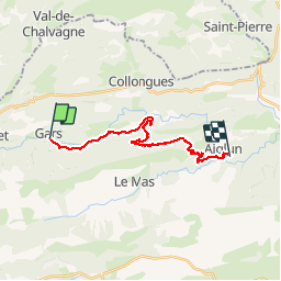
Tour Mountainbike von 18,3 km verfügbar auf Provence-Alpes-Côte d'Azur, Seealpen, Gars. Diese Tour wird von tracegps vorgeschlagen.
Beschreibung
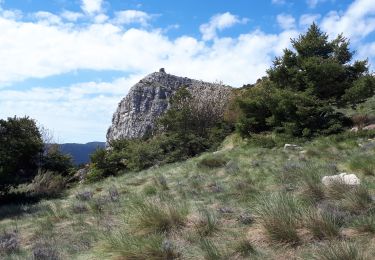
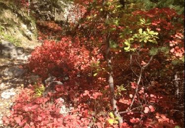
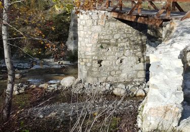
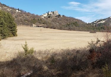
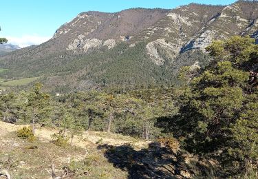
Grande Traversée des Préalpes, les Chemins du Soleil. Parcours officiel labellisé par la Fédération Française de Cyclisme. Une portion tout en douceur vous attend sur ce tronçon au départ de Gars. Vous suivez la rivière de l'Estéron en alternant piste et sentier, dans une atmosphère végétale et plutôt humide en mi saison. Quelques courts poussages casseront votre rythme pour rejoindre l'ascension de la montagne de Charamel. En haut de cette piste un poussage plus soutenu vous mène au sommet d'un single d'où on devine la clue d'Aiglun. Certainement une des descentes les plus difficiles des Chemins du Soleil pour rejoindre Aiglun. Mesure de prudence : prudence en général dans la descente d'Aiglun et en particulier sur la partie haute où le pied à terre est recommandé. Une variante moins difficile est possible en prenant par Le Mas puis rejoindre Aiglun par la route. Consultez toutes les informations sur les hébergements et les services associés sur la fiche du tronçon.
Ort
Kommentare
Touren in der Umgebung
![Tour Zu Fuß Le Mas - Grand tour du haut Estéron - Etape 3 - Photo](https://media.geolcdn.com/t/375/260/849c76bc-5ee3-4c47-be26-b44412646500.jpeg&format=jpg&maxdim=2)
![Zu Fuß Zu Fuß](https://static1.geolcdn.com/sitytour/trail-icons/100.png)
Zu Fuß
![](/images/other/stat-length.png)
![](https://static1.geolcdn.com/siteimages/upload/files/16400158638029165_repeat_loop_refresh_sync_direction_icon.png)
![Tour Zu Fuß Gars - Grand tour du haut Estéron - Etape 2 - Photo](https://media.geolcdn.com/t/375/260/6284f77c-2485-44d3-926e-13cd2a0e2a2c.jpeg&format=jpg&maxdim=2)
![Zu Fuß Zu Fuß](https://static1.geolcdn.com/sitytour/trail-icons/100.png)
Zu Fuß
![](/images/other/stat-length.png)
![](https://static1.geolcdn.com/siteimages/upload/files/16400158638029165_repeat_loop_refresh_sync_direction_icon.png)
![Tour Zu Fuß Le Mas - Montagne de Charamel - Photo](https://media.geolcdn.com/t/375/260/6284f77c-2485-44d3-926e-13cd2a0e2a2c.jpeg&format=jpg&maxdim=2)
![Zu Fuß Zu Fuß](https://static1.geolcdn.com/sitytour/trail-icons/100.png)
Zu Fuß
![](/images/other/stat-length.png)
![](https://static1.geolcdn.com/siteimages/upload/files/16400158638029165_repeat_loop_refresh_sync_direction_icon.png)
![Tour Wandern Saint-Auban - L'arpille près de Sausses - Photo](https://media.geolcdn.com/t/375/260/f208f93f-109e-430d-b59b-03ba9ed984c4.jpg&format=jpg&maxdim=2)
![Wandern Wandern](https://static1.geolcdn.com/sitytour/trail-icons/101.png)
Wandern
![](/images/other/stat-length.png)
![](https://static1.geolcdn.com/siteimages/upload/files/16400158638029165_repeat_loop_refresh_sync_direction_icon.png)
![Tour Wandern Le Mas - Le Masse - charamel - Photo](https://media.geolcdn.com/t/375/260/ext.jpg?maxdim=2&url=https%3A%2F%2Fservices.sitytrail.com%2FGeolivesWS%2FDownloadMedia.ashx%3FTrailID%3D160955%26Media%3D20121102120413.jpg)
![Wandern Wandern](https://static1.geolcdn.com/sitytour/trail-icons/101.png)
Wandern
![](/images/other/stat-length.png)
![](https://static1.geolcdn.com/siteimages/upload/files/16400158638029165_repeat_loop_refresh_sync_direction_icon.png)
![Tour Wandern Le Mas - charamel - Photo](https://media.geolcdn.com/t/375/260/29059ec0-a88e-4f02-b0c9-10e0bb7323f5.jpg&format=jpg&maxdim=2)
![Wandern Wandern](https://static1.geolcdn.com/sitytour/trail-icons/101.png)
Wandern
![](/images/other/stat-length.png)
![](https://static1.geolcdn.com/siteimages/upload/files/16400158638029165_repeat_loop_refresh_sync_direction_icon.png)
![Tour Zu Fuß Amirat - Col du Trébuchet - Photo](https://media.geolcdn.com/t/375/260/ext.jpg?maxdim=2&url=https%3A%2F%2Fstatic1.geolcdn.com%2Fsiteimages%2Fupload%2Ffiles%2F1545311037marcheuse_200dpi.jpg)
![Zu Fuß Zu Fuß](https://static1.geolcdn.com/sitytour/trail-icons/100.png)
Zu Fuß
![](/images/other/stat-length.png)
![](https://static1.geolcdn.com/siteimages/upload/files/16400158638029165_repeat_loop_refresh_sync_direction_icon.png)
![Tour Wandern Gars - Gars - Photo](https://media.geolcdn.com/t/375/260/1bf2290a-2b68-45c6-bd39-413acfec6c55.jpg&format=jpg&maxdim=2)
![Wandern Wandern](https://static1.geolcdn.com/sitytour/trail-icons/101.png)
Wandern
![](/images/other/stat-length.png)
![](https://static1.geolcdn.com/siteimages/upload/files/16400158638029165_repeat_loop_refresh_sync_direction_icon.png)
![Tour Wandern Val-de-Chalvagne - Les Cougnas Col du Buis Ubraye - Photo](https://media.geolcdn.com/t/375/260/ae597dcc-d793-42e8-b1b4-fe34f5b0ca0b.jpg&format=jpg&maxdim=2)
![Wandern Wandern](https://static1.geolcdn.com/sitytour/trail-icons/101.png)
Wandern
![](/images/other/stat-length.png)
![](https://static1.geolcdn.com/siteimages/upload/files/16400158638029165_repeat_loop_refresh_sync_direction_icon.png)