![](/images/other/stat-length.png)
![Tour Wandern Feuchy - Feuchy Fampoux - Photo](https://media.geolcdn.com/t/1900/400/ext.pjpeg?maxdim=2&url=https%3A%2F%2Fstatic1.geolcdn.com%2Fsiteimages%2Fupload%2Ffiles%2F1553511878bg_sport_marche.png)
Feuchy Fampoux
tracegps
Benutzer
![Länge](/images/other/stat-length.png)
Länge
10,8 km
![Maximale Höhe](https://static1.geolcdn.com/siteimages/upload/files/1508320355ic_sort_altitude_max_24dp.png)
Maximale Höhe
100 m
![Positive Höhendifferenz](https://static1.geolcdn.com/siteimages/upload/files/1508320355ic_sort_den_pos_24dp.png)
Positive Höhendifferenz
99 m
![Km-Effort](/images/other/stat-length.png)
Km-Effort
12,1 km
![Min. Höhe](https://static1.geolcdn.com/siteimages/upload/files/1508320355ic_sort_altitude_min_24dp.png)
Min. Höhe
46 m
![Negative Höhendifferenz](https://static1.geolcdn.com/siteimages/upload/files/1508320355ic_sort_den_neg_24dp.png)
Negative Höhendifferenz
100 m
![Boucle](https://static1.geolcdn.com/siteimages/upload/files/16400158638029165_repeat_loop_refresh_sync_direction_icon.png)
Boucle
Ja
Erstellungsdatum :
2014-12-10 00:00:00.0
Letzte Änderung :
2014-12-10 00:00:00.0
![Wandern](https://static1.geolcdn.com/sitytour/trail-icons/101.png)
2h00
Schwierigkeit : Medium
![Scannen Sie diesen QR-Code, um die Tour in der SityTrail-Anwendung zu öffnen](https://capi.geolives.com/qq0zvz2zws4bq2lad0pu/sitytour/trails/104714/qr.png?size=200)
Kostenlosegpshiking-Anwendung
Über SityTrail
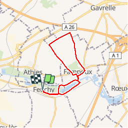
Tour Wandern von 10,8 km verfügbar auf Nordfrankreich, Pas-de-Calais, Feuchy. Diese Tour wird von tracegps vorgeschlagen.
Beschreibung
Randonnée au départ de Feuchy qui nous emmène à Fampoux en longeant les marais, puis dans les champs au dessus de Fampoux et nous fait rejoindre le point de départ en longeant la Scarpe et en traversant un marais.
Ort
Land:
France
Region :
Nordfrankreich
Abteilung/Provinz :
Pas-de-Calais
Kommune :
Feuchy
Standort:
Unknown
Gehen Sie:(Dec)
Gehen Sie:(UTM)
488929 ; 5571338 (31U) N.
Kommentare
Touren in der Umgebung
![Tour Wandern Athies - Le chemin du Maresquay - Athies - Photo](https://media.geolcdn.com/t/375/260/ext.jpg?maxdim=2&url=https%3A%2F%2Fservices.sitytrail.com%2FGeolivesWS%2FDownloadMedia.ashx%3FTrailID%3D110048%26Media%3D5157_6.jpg)
![Wandern Wandern](https://static1.geolcdn.com/sitytour/trail-icons/101.png)
Le chemin du Maresquay - Athies
Wandern
Schwierig
(1)
Athies,
Nordfrankreich,
Pas-de-Calais,
France
![](/images/other/stat-length.png)
12,9 km | 14,3 km-effort
3h 15min
![](https://static1.geolcdn.com/siteimages/upload/files/16400158638029165_repeat_loop_refresh_sync_direction_icon.png)
Ja
![Tour Wandern Monchy-le-Preux - Le chemin du Caribou - Monchy le Preux - Photo](https://media.geolcdn.com/t/375/260/ext.jpg?maxdim=2&url=https%3A%2F%2Fservices.sitytrail.com%2FGeolivesWS%2FDownloadMedia.ashx%3FTrailID%3D109907%26Media%3D4917_5.jpg)
![Wandern Wandern](https://static1.geolcdn.com/sitytour/trail-icons/101.png)
Le chemin du Caribou - Monchy le Preux
Wandern
Medium
(1)
Monchy-le-Preux,
Nordfrankreich,
Pas-de-Calais,
France
![](/images/other/stat-length.png)
9,2 km | 10,1 km-effort
2h 19min
![](https://static1.geolcdn.com/siteimages/upload/files/16400158638029165_repeat_loop_refresh_sync_direction_icon.png)
Ja
![Tour Wandern Arras - Arras Citadelles Grands Prés 16,5 km - Photo](https://media.geolcdn.com/t/375/260/c9502adb-d79d-4714-8dca-e315baf425eb.jpg&format=jpg&maxdim=2)
![Wandern Wandern](https://static1.geolcdn.com/sitytour/trail-icons/101.png)
Arras Citadelles Grands Prés 16,5 km
Wandern
Schwierig
Arras,
Nordfrankreich,
Pas-de-Calais,
France
![](/images/other/stat-length.png)
16,4 km | 18,2 km-effort
4h 8min
![](https://static1.geolcdn.com/siteimages/upload/files/16400158638029165_repeat_loop_refresh_sync_direction_icon.png)
Ja
![Tour Wandern Arras - Beffroi à citadelle d'Arras - Photo](https://media.geolcdn.com/t/375/260/ext.jpg?maxdim=2&url=https%3A%2F%2Fservices.sitytrail.com%2FGeolivesWS%2FDownloadMedia.ashx%3FTrailID%3D945061%26Media%3D20180417064753.jpg)
![Wandern Wandern](https://static1.geolcdn.com/sitytour/trail-icons/101.png)
Beffroi à citadelle d'Arras
Wandern
Sehr leicht
Arras,
Nordfrankreich,
Pas-de-Calais,
France
![](/images/other/stat-length.png)
7,6 km | 8,5 km-effort
1h 31min
![](https://static1.geolcdn.com/siteimages/upload/files/16400158638029165_repeat_loop_refresh_sync_direction_icon.png)
Ja
![Tour Wandern Arras - La Route du Louvre «La Canadienne» - Arras - Photo](https://media.geolcdn.com/t/375/260/ext.jpg?maxdim=2&url=https%3A%2F%2Fservices.sitytrail.com%2FGeolivesWS%2FDownloadMedia.ashx%3FTrailID%3D317920%26Media%3D17338_6.jpg)
![Wandern Wandern](https://static1.geolcdn.com/sitytour/trail-icons/101.png)
La Route du Louvre «La Canadienne» - Arras
Wandern
Medium
Arras,
Nordfrankreich,
Pas-de-Calais,
France
![](/images/other/stat-length.png)
24 km | 27 km-effort
5h 30min
![](https://static1.geolcdn.com/siteimages/upload/files/16400158638029165_repeat_loop_refresh_sync_direction_icon.png)
Nein
![Tour Wandern Rœux - De Roeux à Pelves via Monchy-le-Preux - Photo](https://media.geolcdn.com/t/375/260/ext.jpg?maxdim=2&url=https%3A%2F%2Fservices.sitytrail.com%2FGeolivesWS%2FDownloadMedia.ashx%3FTrailID%3D191391%26Media%3D14962_6.jpg)
![Wandern Wandern](https://static1.geolcdn.com/sitytour/trail-icons/101.png)
De Roeux à Pelves via Monchy-le-Preux
Wandern
Medium
Rœux,
Nordfrankreich,
Pas-de-Calais,
France
![](/images/other/stat-length.png)
9,5 km | 10,6 km-effort
2h 30min
![](https://static1.geolcdn.com/siteimages/upload/files/16400158638029165_repeat_loop_refresh_sync_direction_icon.png)
Ja
![Tour Wandern Rœux - De Roeux à Plouvain - Photo](https://media.geolcdn.com/t/375/260/ext.jpg?maxdim=2&url=https%3A%2F%2Fservices.sitytrail.com%2FGeolivesWS%2FDownloadMedia.ashx%3FTrailID%3D173057%26Media%3D14581_4.jpg)
![Wandern Wandern](https://static1.geolcdn.com/sitytour/trail-icons/101.png)
De Roeux à Plouvain
Wandern
Einfach
Rœux,
Nordfrankreich,
Pas-de-Calais,
France
![](/images/other/stat-length.png)
6,3 km | 6,6 km-effort
1h 34min
![](https://static1.geolcdn.com/siteimages/upload/files/16400158638029165_repeat_loop_refresh_sync_direction_icon.png)
Ja
![Tour Wandern Rœux - Lacs et marais - Roeux - Photo](https://media.geolcdn.com/t/375/260/ext.jpg?maxdim=2&url=https%3A%2F%2Fservices.sitytrail.com%2FGeolivesWS%2FDownloadMedia.ashx%3FTrailID%3D172538%26Media%3D13904_6.jpg)
![Wandern Wandern](https://static1.geolcdn.com/sitytour/trail-icons/101.png)
Lacs et marais - Roeux
Wandern
Sehr schwierig
Rœux,
Nordfrankreich,
Pas-de-Calais,
France
![](/images/other/stat-length.png)
18,3 km | 19,6 km-effort
4h 30min
![](https://static1.geolcdn.com/siteimages/upload/files/16400158638029165_repeat_loop_refresh_sync_direction_icon.png)
Ja
![Tour Wandern Fampoux - Des bords de la Scarpe - Fampoux - Photo](https://media.geolcdn.com/t/375/260/ext.jpg?maxdim=2&url=https%3A%2F%2Fservices.sitytrail.com%2FGeolivesWS%2FDownloadMedia.ashx%3FTrailID%3D110055%26Media%3D5164_5.jpg)
![Wandern Wandern](https://static1.geolcdn.com/sitytour/trail-icons/101.png)
Des bords de la Scarpe - Fampoux
Wandern
Medium
Fampoux,
Nordfrankreich,
Pas-de-Calais,
France
![](/images/other/stat-length.png)
9,6 km | 10,5 km-effort
2h 25min
![](https://static1.geolcdn.com/siteimages/upload/files/16400158638029165_repeat_loop_refresh_sync_direction_icon.png)
Ja