![](/images/other/stat-length.png)
![Tour Laufen Saint-Omer - Clécy 14 km - Photo](https://media.geolcdn.com/t/1900/400/ext.pjpeg?maxdim=2&url=https%3A%2F%2Fservices.sitytrail.com%2FGeolivesWS%2FDownloadMedia.ashx%3FTrailID%3D104650%26Media%3D8037_2.jpg)
Clécy 14 km
tracegps
Benutzer
![Länge](/images/other/stat-length.png)
Länge
14 km
![Maximale Höhe](https://static1.geolcdn.com/siteimages/upload/files/1508320355ic_sort_altitude_max_24dp.png)
Maximale Höhe
290 m
![Positive Höhendifferenz](https://static1.geolcdn.com/siteimages/upload/files/1508320355ic_sort_den_pos_24dp.png)
Positive Höhendifferenz
370 m
![Km-Effort](/images/other/stat-length.png)
Km-Effort
18,9 km
![Min. Höhe](https://static1.geolcdn.com/siteimages/upload/files/1508320355ic_sort_altitude_min_24dp.png)
Min. Höhe
38 m
![Negative Höhendifferenz](https://static1.geolcdn.com/siteimages/upload/files/1508320355ic_sort_den_neg_24dp.png)
Negative Höhendifferenz
365 m
![Boucle](https://static1.geolcdn.com/siteimages/upload/files/16400158638029165_repeat_loop_refresh_sync_direction_icon.png)
Boucle
Ja
Erstellungsdatum :
2014-12-10 00:00:00.0
Letzte Änderung :
2014-12-10 00:00:00.0
![Laufen](https://static1.geolcdn.com/sitytour/trail-icons/103.png)
1h30
Schwierigkeit : Schwierig
![Scannen Sie diesen QR-Code, um die Tour in der SityTrail-Anwendung zu öffnen](https://capi.geolives.com/qq0zvz2zws4bq2lad0pu/sitytour/trails/104650/qr.png?size=200)
Kostenlosegpshiking-Anwendung
Über SityTrail
Tour Laufen von 14 km verfügbar auf Normandie, Calvados, Saint-Omer. Diese Tour wird von tracegps vorgeschlagen.
Beschreibung
Départ du site de vol libre sur les hauteurs de St Rémy. Petite boucle très agréable pour une petite randonnée avec un peu de dénivelé. Cela peut faire une petite sortie Jogging un peu physique mais courte. Bonne balade!
Ort
Land:
France
Region :
Normandie
Abteilung/Provinz :
Calvados
Kommune :
Saint-Omer
Standort:
Unknown
Gehen Sie:(Dec)
Gehen Sie:(UTM)
685301 ; 5422776 (30U) N.
Kommentare
Touren in der Umgebung
![Tour Mountainbike Saint-Omer - Espace VTT FFC de Suisse Normande - Circuit 11 - Saint Omer - Photo](https://media.geolcdn.com/t/375/260/ext.jpg?maxdim=2&url=https%3A%2F%2Fservices.sitytrail.com%2FGeolivesWS%2FDownloadMedia.ashx%3FTrailID%3D106820%26Media%3D11522_1.jpg)
![Mountainbike Mountainbike](https://static1.geolcdn.com/sitytour/trail-icons/202.png)
Espace VTT FFC de Suisse Normande - Circuit 11 - Saint Omer
Mountainbike
Sehr schwierig
(1)
Saint-Omer,
Normandie,
Calvados,
France
![](/images/other/stat-length.png)
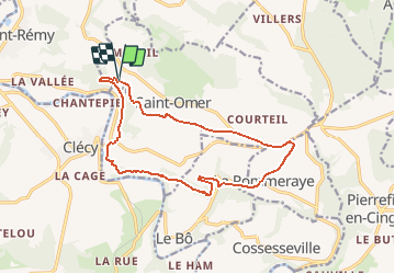
25 km | 34 km-effort
3h 0min
![](https://static1.geolcdn.com/siteimages/upload/files/16400158638029165_repeat_loop_refresh_sync_direction_icon.png)
Ja
![Tour Wandern Le Vey - Clécy - Photo](https://media.geolcdn.com/t/375/260/128372da-8bde-41a3-bf52-ea6a6766f39f.jpg&format=jpg&maxdim=2)
![Wandern Wandern](https://static1.geolcdn.com/sitytour/trail-icons/101.png)
![Tour Zu Fuß Le Bô - Des Montagnes de Normandie? - Photo](https://media.geolcdn.com/t/375/260/99446ac7-841c-43b2-a8d0-7ad8496245d0.jpeg&format=jpg&maxdim=2)
![Zu Fuß Zu Fuß](https://static1.geolcdn.com/sitytour/trail-icons/100.png)
Des Montagnes de Normandie?
Zu Fuß
Medium
Le Bô,
Normandie,
Calvados,
France
![](/images/other/stat-length.png)
15,4 km | 20 km-effort
4h 38min
![](https://static1.geolcdn.com/siteimages/upload/files/16400158638029165_repeat_loop_refresh_sync_direction_icon.png)
Nein
![Tour Zu Fuß Esson - La Chapelle Bonne Nouvelle - Photo](https://media.geolcdn.com/t/375/260/82717480-a9c2-41c9-93af-e42d631dbd18.jpeg&format=jpg&maxdim=2)
![Zu Fuß Zu Fuß](https://static1.geolcdn.com/sitytour/trail-icons/100.png)
La Chapelle Bonne Nouvelle
Zu Fuß
Einfach
Esson,
Normandie,
Calvados,
France
![](/images/other/stat-length.png)
9,5 km | 13,3 km-effort
3h 1min
![](https://static1.geolcdn.com/siteimages/upload/files/16400158638029165_repeat_loop_refresh_sync_direction_icon.png)
Ja
![Tour Zu Fuß La Pommeraye - Les Rochers de Briesvieille - Photo](https://media.geolcdn.com/t/375/260/99446ac7-841c-43b2-a8d0-7ad8496245d0.jpeg&format=jpg&maxdim=2)
![Zu Fuß Zu Fuß](https://static1.geolcdn.com/sitytour/trail-icons/100.png)
Les Rochers de Briesvieille
Zu Fuß
Einfach
(1)
La Pommeraye,
Normandie,
Calvados,
France
![](/images/other/stat-length.png)
9,1 km | 12,9 km-effort
2h 55min
![](https://static1.geolcdn.com/siteimages/upload/files/16400158638029165_repeat_loop_refresh_sync_direction_icon.png)
Nein
![Tour Zu Fuß Le Bô - Le Moulin à Papier - Photo](https://media.geolcdn.com/t/375/260/3ac248d0-9006-472c-b1a7-3308f2fe9984.jpeg&format=jpg&maxdim=2)
![Zu Fuß Zu Fuß](https://static1.geolcdn.com/sitytour/trail-icons/100.png)
Le Moulin à Papier
Zu Fuß
Einfach
Le Bô,
Normandie,
Calvados,
France
![](/images/other/stat-length.png)
7,1 km | 9,6 km-effort
2h 11min
![](https://static1.geolcdn.com/siteimages/upload/files/16400158638029165_repeat_loop_refresh_sync_direction_icon.png)
Ja
![Tour Zu Fuß Esson - GRP Tour de la Suisse Normande - Photo](https://media.geolcdn.com/t/375/260/96471841-70b2-445a-bcf9-e6471b393594.jpeg&format=jpg&maxdim=2)
![Zu Fuß Zu Fuß](https://static1.geolcdn.com/sitytour/trail-icons/100.png)
GRP Tour de la Suisse Normande
Zu Fuß
Schwierig
Esson,
Normandie,
Calvados,
France
![](/images/other/stat-length.png)
25 km | 35 km-effort
7h 58min
![](https://static1.geolcdn.com/siteimages/upload/files/16400158638029165_repeat_loop_refresh_sync_direction_icon.png)
Nein
![Tour Mountainbike Saint-Rémy - VTT Suisse Normande N°10 - St Rémy sur Orne - Photo](https://media.geolcdn.com/t/375/260/ext.jpg?maxdim=2&url=https%3A%2F%2Fservices.sitytrail.com%2FGeolivesWS%2FDownloadMedia.ashx%3FTrailID%3D173106%26Media%3D14655_3.jpg)
![Mountainbike Mountainbike](https://static1.geolcdn.com/sitytour/trail-icons/202.png)
VTT Suisse Normande N°10 - St Rémy sur Orne
Mountainbike
Einfach
Saint-Rémy,
Normandie,
Calvados,
France
![](/images/other/stat-length.png)
15,8 km | 20 km-effort
1h 30min
![](https://static1.geolcdn.com/siteimages/upload/files/16400158638029165_repeat_loop_refresh_sync_direction_icon.png)
Ja
![Tour Wandern Clécy - Clecy - Pontecoulant - Photo](https://media.geolcdn.com/t/375/260/b526017d-e01f-4175-825c-320fed21cc05.jpg&format=jpg&maxdim=2)
![Wandern Wandern](https://static1.geolcdn.com/sitytour/trail-icons/101.png)
Clecy - Pontecoulant
Wandern
Schwierig
Clécy,
Normandie,
Calvados,
France
![](/images/other/stat-length.png)
11,7 km | 15,9 km-effort
2h 36min
![](https://static1.geolcdn.com/siteimages/upload/files/16400158638029165_repeat_loop_refresh_sync_direction_icon.png)
Nein