![](/images/other/stat-length.png)
![Tour Wandern Cambayrac - Hauts de Landorre - Cambayrac - Photo](https://media.geolcdn.com/t/1900/400/ext.pjpeg?maxdim=2&url=https%3A%2F%2Fstatic1.geolcdn.com%2Fsiteimages%2Fupload%2Ffiles%2F1553511878bg_sport_marche.png)
Hauts de Landorre - Cambayrac
tracegps
Benutzer
![Länge](/images/other/stat-length.png)
![Maximale Höhe](https://static1.geolcdn.com/siteimages/upload/files/1508320355ic_sort_altitude_max_24dp.png)
![Positive Höhendifferenz](https://static1.geolcdn.com/siteimages/upload/files/1508320355ic_sort_den_pos_24dp.png)
![Km-Effort](/images/other/stat-length.png)
![Min. Höhe](https://static1.geolcdn.com/siteimages/upload/files/1508320355ic_sort_altitude_min_24dp.png)
![Negative Höhendifferenz](https://static1.geolcdn.com/siteimages/upload/files/1508320355ic_sort_den_neg_24dp.png)
![Boucle](https://static1.geolcdn.com/siteimages/upload/files/16400158638029165_repeat_loop_refresh_sync_direction_icon.png)
![Wandern](https://static1.geolcdn.com/sitytour/trail-icons/101.png)
1h30
Schwierigkeit : Schwierig
![Scannen Sie diesen QR-Code, um die Tour in der SityTrail-Anwendung zu öffnen](https://capi.geolives.com/qq0zvz2zws4bq2lad0pu/sitytour/trails/104622/qr.png?size=200)
Kostenlosegpshiking-Anwendung
Über SityTrail
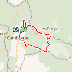
Tour Wandern von 5,9 km verfügbar auf Okzitanien, Lot, Cambayrac. Diese Tour wird von tracegps vorgeschlagen.
Beschreibung
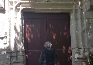
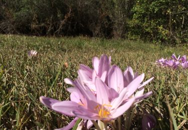
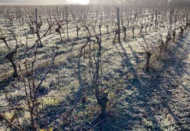
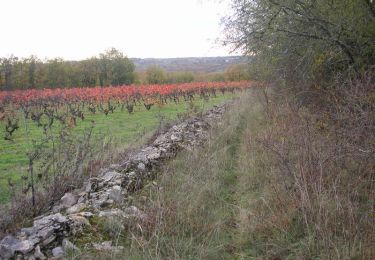
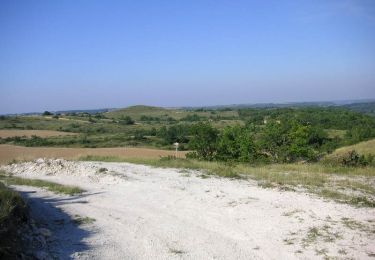
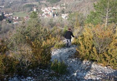
Petit circuit de 6 km dominant le ravin de Landorre, essentiellement sur sentier, avec quelques montées assez raides pouvant présenter des difficultés pour des personnes peu habituées à la marche en montagne. À Cambayrac prendre la rue qui descend à gauche de l'église, puis en face vers la station d'épuration la petite route qui mène aux Grèzes. Laisser à droite une route qui revient vers le village. Après le panneau "Algombert", prendre juste après une maison en ruines,un sentier qui monte sur la droite. Rejoindre la route des Grèzes et la suivre sur quelques mètres avant de prendre en face un sentier à droite de la route. La rejoindre de nouveau au niveau d'un pont, la suivre sur une centaine de mètres puis prendre sur la gauche un sentier assez raide, tracé par les motos, qui monte à flanc de colline. Au sommet suivre une vigne jusqu'à un chemin assez large que l'on prend sur la gauche. Après 7 à 800 mètres, à un carrefour en T, prendre à gauche un chemin herbu et, lorsque celui-ci part à gauche à 90°, prendre un sentier à droite sur quelques mètres (cairn au pied d'un arbre) puis un autre à gauche. Le suivre dans sa montée le long de la falaise puis, peu après un poteau électrique, laisser à droite un sentier qui monte vers Les Roques et continuer tout droit la descente vers le fond du ruisseau de Landorre, que l'on traverse pour arriver à un carrefour. Prendre en face un petit sentier peu visible qui grimpe dans la falaise. Lorsque ce sentier rejoint un chemin plus large, prendre celui-ci sur la gauche et rejoindre le centre de Cambayrac. Nous avons fait ce circuit avec des enfants sans problème, mais certaines personnes âgées pourraient avoir des difficultés dans les montées.
Ort
Kommentare
Touren in der Umgebung
![Tour Wandern Saint-Vincent-Rive-d'Olt - St Vincent-rive d’Holt (Lot) - Photo](https://media.geolcdn.com/t/375/260/ext.jpg?maxdim=2&url=https%3A%2F%2Fstatic1.geolcdn.com%2Fsiteimages%2Fupload%2Ffiles%2F1553511878bg_sport_marche.png)
![Wandern Wandern](https://static1.geolcdn.com/sitytour/trail-icons/101.png)
Wandern
![](/images/other/stat-length.png)
![](https://static1.geolcdn.com/siteimages/upload/files/16400158638029165_repeat_loop_refresh_sync_direction_icon.png)
![Tour Wandern Villesèque - Villeseque Bagat - Photo](https://media.geolcdn.com/t/375/260/ec6d9a06-1d51-4f88-bd7e-9dc66bcc1e16.jpg&format=jpg&maxdim=2)
![Wandern Wandern](https://static1.geolcdn.com/sitytour/trail-icons/101.png)
Wandern
![](/images/other/stat-length.png)
![](https://static1.geolcdn.com/siteimages/upload/files/16400158638029165_repeat_loop_refresh_sync_direction_icon.png)
![Tour Mountainbike Sauzet - De Sauzet à Luzech - Photo](https://media.geolcdn.com/t/375/260/ext.jpg?maxdim=2&url=https%3A%2F%2Fservices.sitytrail.com%2FGeolivesWS%2FDownloadMedia.ashx%3FTrailID%3D173050%26Media%3D14571_6.jpg)
![Mountainbike Mountainbike](https://static1.geolcdn.com/sitytour/trail-icons/202.png)
Mountainbike
![](/images/other/stat-length.png)
![](https://static1.geolcdn.com/siteimages/upload/files/16400158638029165_repeat_loop_refresh_sync_direction_icon.png)
![Tour Wandern Sauzet - De Sauzet à Luzech - Photo](https://media.geolcdn.com/t/375/260/ext.jpg?maxdim=2&url=https%3A%2F%2Fservices.sitytrail.com%2FGeolivesWS%2FDownloadMedia.ashx%3FTrailID%3D173049%26Media%3D14571_6.jpg)
![Wandern Wandern](https://static1.geolcdn.com/sitytour/trail-icons/101.png)
Wandern
![](/images/other/stat-length.png)
![](https://static1.geolcdn.com/siteimages/upload/files/16400158638029165_repeat_loop_refresh_sync_direction_icon.png)
![Tour Mountainbike Sauzet - De Sauzet à St Pantaléon - Photo](https://media.geolcdn.com/t/375/260/ext.jpg?maxdim=2&url=https%3A%2F%2Fservices.sitytrail.com%2FGeolivesWS%2FDownloadMedia.ashx%3FTrailID%3D106822%26Media%3D11523_4.jpg)
![Mountainbike Mountainbike](https://static1.geolcdn.com/sitytour/trail-icons/202.png)
Mountainbike
![](/images/other/stat-length.png)
![](https://static1.geolcdn.com/siteimages/upload/files/16400158638029165_repeat_loop_refresh_sync_direction_icon.png)
![Tour Wandern Sauzet - De Sauzet à St Pantaléon - Photo](https://media.geolcdn.com/t/375/260/ext.jpg?maxdim=2&url=https%3A%2F%2Fservices.sitytrail.com%2FGeolivesWS%2FDownloadMedia.ashx%3FTrailID%3D106821%26Media%3D11523_4.jpg)
![Wandern Wandern](https://static1.geolcdn.com/sitytour/trail-icons/101.png)
Wandern
![](/images/other/stat-length.png)
![](https://static1.geolcdn.com/siteimages/upload/files/16400158638029165_repeat_loop_refresh_sync_direction_icon.png)
![Tour Wandern Saint-Vincent-Rive-d'Olt - Point de vue sur le cingle de Luzech - Photo](https://media.geolcdn.com/t/375/260/ext.jpg?maxdim=2&url=https%3A%2F%2Fservices.sitytrail.com%2FGeolivesWS%2FDownloadMedia.ashx%3FTrailID%3D104694%26Media%3D8100_5.jpg)
![Wandern Wandern](https://static1.geolcdn.com/sitytour/trail-icons/101.png)
Wandern
![](/images/other/stat-length.png)
![](https://static1.geolcdn.com/siteimages/upload/files/16400158638029165_repeat_loop_refresh_sync_direction_icon.png)
![Tour Wandern Cambayrac - Cambeyrac - Photo](https://media.geolcdn.com/t/375/260/72c71246-2c5c-461f-8958-64c97cdfa70a.jpg&format=jpg&maxdim=2)
![Wandern Wandern](https://static1.geolcdn.com/sitytour/trail-icons/101.png)
![Tour Wandern Villesèque - Trebai 3 - Photo](https://media.geolcdn.com/t/375/260/72664e9f-0f4c-48b9-badb-2b2b5b4d2989.jpg&format=jpg&maxdim=2)
![Wandern Wandern](https://static1.geolcdn.com/sitytour/trail-icons/101.png)