![](/images/other/stat-length.png)
![Tour Laufen Trets - Regagnas - Ermitage de Saint Jean du Puy - Photo](https://media.geolcdn.com/t/1900/400/ext.pjpeg?maxdim=2&url=https%3A%2F%2Fservices.sitytrail.com%2FGeolivesWS%2FDownloadMedia.ashx%3FTrailID%3D104460%26Media%3D7738_1.jpg)
Regagnas - Ermitage de Saint Jean du Puy
tracegps
Benutzer
![Länge](/images/other/stat-length.png)
Länge
8,7 km
![Maximale Höhe](https://static1.geolcdn.com/siteimages/upload/files/1508320355ic_sort_altitude_max_24dp.png)
Maximale Höhe
642 m
![Positive Höhendifferenz](https://static1.geolcdn.com/siteimages/upload/files/1508320355ic_sort_den_pos_24dp.png)
Positive Höhendifferenz
278 m
![Km-Effort](/images/other/stat-length.png)
Km-Effort
12,4 km
![Min. Höhe](https://static1.geolcdn.com/siteimages/upload/files/1508320355ic_sort_altitude_min_24dp.png)
Min. Höhe
430 m
![Negative Höhendifferenz](https://static1.geolcdn.com/siteimages/upload/files/1508320355ic_sort_den_neg_24dp.png)
Negative Höhendifferenz
278 m
![Boucle](https://static1.geolcdn.com/siteimages/upload/files/16400158638029165_repeat_loop_refresh_sync_direction_icon.png)
Boucle
Ja
Erstellungsdatum :
2014-12-10 00:00:00.0
Letzte Änderung :
2014-12-10 00:00:00.0
![Laufen](https://static1.geolcdn.com/sitytour/trail-icons/103.png)
1h10
Schwierigkeit : Medium
![Scannen Sie diesen QR-Code, um die Tour in der SityTrail-Anwendung zu öffnen](https://capi.geolives.com/qq0zvz2zws4bq2lad0pu/sitytour/trails/104460/qr.png?size=200)
Kostenlosegpshiking-Anwendung
Über SityTrail
Tour Laufen von 8,7 km verfügbar auf Provence-Alpes-Côte d'Azur, Bouches-du-Rhône, Trets. Diese Tour wird von tracegps vorgeschlagen.
Beschreibung
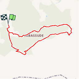
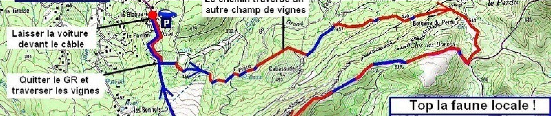
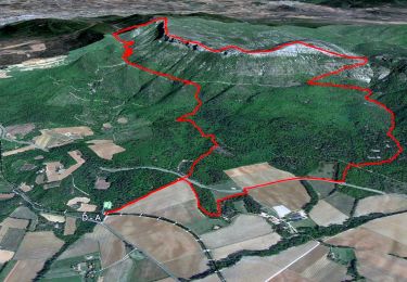
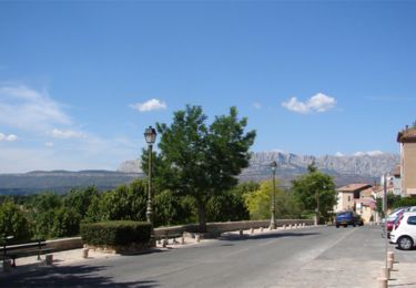
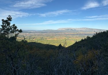
On aurait tendance à monter à l'Ermitage de Saint Jean du Puy par Saint- Zacharie, mais il vaut mieux y aller par Trets. Ca monte moins et ça permet un bon footing super sympa !
Ort
Land:
France
Region :
Provence-Alpes-Côte d'Azur
Abteilung/Provinz :
Bouches-du-Rhône
Kommune :
Trets
Standort:
Unknown
Gehen Sie:(Dec)
Gehen Sie:(UTM)
718145 ; 4812044 (31T) N.
Kommentare
Touren in der Umgebung
![Tour Mountainbike Trets - les contreforts du mont Olympe - Photo](https://media.geolcdn.com/t/375/260/ext.jpg?maxdim=2&url=https%3A%2F%2Fservices.sitytrail.com%2FGeolivesWS%2FDownloadMedia.ashx%3FTrailID%3D675672%26Media%3Dfix__20161223150806.jpg)
![Mountainbike Mountainbike](https://static1.geolcdn.com/sitytour/trail-icons/202.png)
les contreforts du mont Olympe
Mountainbike
Einfach
(1)
Trets,
Provence-Alpes-Côte d'Azur,
Bouches-du-Rhône,
France
![](/images/other/stat-length.png)
11,8 km | 15,5 km-effort
2h 52min
![](https://static1.geolcdn.com/siteimages/upload/files/16400158638029165_repeat_loop_refresh_sync_direction_icon.png)
Ja
![Tour Wandern Pourrières - JPS Monts Aurélien-17655561 - Photo](https://media.geolcdn.com/t/375/260/8dbb5ea6-c181-4e2b-88a9-6319fd5fd375.jpg&format=jpg&maxdim=2)
![Wandern Wandern](https://static1.geolcdn.com/sitytour/trail-icons/101.png)
JPS Monts Aurélien-17655561
Wandern
Medium
(1)
Pourrières,
Provence-Alpes-Côte d'Azur,
Var,
France
![](/images/other/stat-length.png)
17,3 km | 27 km-effort
7h 0min
![](https://static1.geolcdn.com/siteimages/upload/files/16400158638029165_repeat_loop_refresh_sync_direction_icon.png)
Ja
![Tour Wandern Peynier - De Peynier aux ruines de Dalbessy - Photo](https://media.geolcdn.com/t/375/260/ext.jpg?maxdim=2&url=https%3A%2F%2Fservices.sitytrail.com%2FGeolivesWS%2FDownloadMedia.ashx%3FTrailID%3D973579%26Media%3D6761_1.jpg)
![Wandern Wandern](https://static1.geolcdn.com/sitytour/trail-icons/101.png)
De Peynier aux ruines de Dalbessy
Wandern
Medium
(1)
Peynier,
Provence-Alpes-Côte d'Azur,
Bouches-du-Rhône,
France
![](/images/other/stat-length.png)
8 km | 10,6 km-effort
2h 16min
![](https://static1.geolcdn.com/siteimages/upload/files/16400158638029165_repeat_loop_refresh_sync_direction_icon.png)
Ja
![Tour Wandern Peynier - De Peynier aux ruines de Dalbessy - Photo](https://media.geolcdn.com/t/375/260/ext.jpg?maxdim=2&url=https%3A%2F%2Fservices.sitytrail.com%2FGeolivesWS%2FDownloadMedia.ashx%3FTrailID%3D103913%26Media%3D6761_1.jpg)
![Wandern Wandern](https://static1.geolcdn.com/sitytour/trail-icons/101.png)
De Peynier aux ruines de Dalbessy
Wandern
Medium
(2)
Peynier,
Provence-Alpes-Côte d'Azur,
Bouches-du-Rhône,
France
![](/images/other/stat-length.png)
8 km | 10,6 km-effort
2h 0min
![](https://static1.geolcdn.com/siteimages/upload/files/16400158638029165_repeat_loop_refresh_sync_direction_icon.png)
Ja
![Tour Wandern Trets - Sentier des vignes Trets - Photo](https://media.geolcdn.com/t/375/260/ext.jpg?maxdim=2&url=https%3A%2F%2Fstatic1.geolcdn.com%2Fsiteimages%2Fupload%2Ffiles%2F1553511878bg_sport_marche.png)
![Wandern Wandern](https://static1.geolcdn.com/sitytour/trail-icons/101.png)
Sentier des vignes Trets
Wandern
Medium
(1)
Trets,
Provence-Alpes-Côte d'Azur,
Bouches-du-Rhône,
France
![](/images/other/stat-length.png)
13,2 km | 16,9 km-effort
2h 55min
![](https://static1.geolcdn.com/siteimages/upload/files/16400158638029165_repeat_loop_refresh_sync_direction_icon.png)
Ja
![Tour Wandern Pourrières - Mt Olympe et le pas du Titet - Photo](https://media.geolcdn.com/t/375/260/dc918a12-1c27-4a5f-a427-bc8e0fdbc469.jpg&format=jpg&maxdim=2)
![Wandern Wandern](https://static1.geolcdn.com/sitytour/trail-icons/101.png)
Mt Olympe et le pas du Titet
Wandern
Schwierig
Pourrières,
Provence-Alpes-Côte d'Azur,
Var,
France
![](/images/other/stat-length.png)
19,9 km | 32 km-effort
7h 15min
![](https://static1.geolcdn.com/siteimages/upload/files/16400158638029165_repeat_loop_refresh_sync_direction_icon.png)
Ja
![Tour Wandern Trets - SityTrail - mont olympe + crête - Photo](https://media.geolcdn.com/t/375/260/ext.jpg?maxdim=2&url=https%3A%2F%2Fstatic1.geolcdn.com%2Fsiteimages%2Fupload%2Ffiles%2F1553511878bg_sport_marche.png)
![Wandern Wandern](https://static1.geolcdn.com/sitytour/trail-icons/101.png)
SityTrail - mont olympe + crête
Wandern
Sehr schwierig
(1)
Trets,
Provence-Alpes-Côte d'Azur,
Bouches-du-Rhône,
France
![](/images/other/stat-length.png)
13 km | 21 km-effort
4h 44min
![](https://static1.geolcdn.com/siteimages/upload/files/16400158638029165_repeat_loop_refresh_sync_direction_icon.png)
Ja
![Tour Wandern Pourrières - Pourcieux :Mont Olympe et Pas du Titet - Photo](https://media.geolcdn.com/t/375/260/bc3de33d-3e9b-495a-a14b-a8c68a4f3699.jpg&format=jpg&maxdim=2)
![Wandern Wandern](https://static1.geolcdn.com/sitytour/trail-icons/101.png)
Pourcieux :Mont Olympe et Pas du Titet
Wandern
Sehr schwierig
(1)
Pourrières,
Provence-Alpes-Côte d'Azur,
Var,
France
![](/images/other/stat-length.png)
20 km | 32 km-effort
7h 22min
![](https://static1.geolcdn.com/siteimages/upload/files/16400158638029165_repeat_loop_refresh_sync_direction_icon.png)
Nein
![Tour Wandern Trets - Kirbon 2 juin 2022 - Photo](https://media.geolcdn.com/t/375/260/f3523999-04c3-4dde-8f07-c7ab2536ff96.jpg&format=jpg&maxdim=2)
![Wandern Wandern](https://static1.geolcdn.com/sitytour/trail-icons/101.png)
Kirbon 2 juin 2022
Wandern
Schwierig
Trets,
Provence-Alpes-Côte d'Azur,
Bouches-du-Rhône,
France
![](/images/other/stat-length.png)
11 km | 16,7 km-effort
7h 41min
![](https://static1.geolcdn.com/siteimages/upload/files/16400158638029165_repeat_loop_refresh_sync_direction_icon.png)
Ja