![](/images/other/stat-length.png)
![Tour Wandern Souchez - Souchez Lorette Carency - Photo](https://media.geolcdn.com/t/1900/400/ext.pjpeg?maxdim=2&url=https%3A%2F%2Fservices.sitytrail.com%2FGeolivesWS%2FDownloadMedia.ashx%3FTrailID%3D104455%26Media%3D7731_1.jpg)
Souchez Lorette Carency
tracegps
Benutzer
![Länge](/images/other/stat-length.png)
Länge
9,7 km
![Maximale Höhe](https://static1.geolcdn.com/siteimages/upload/files/1508320355ic_sort_altitude_max_24dp.png)
Maximale Höhe
173 m
![Positive Höhendifferenz](https://static1.geolcdn.com/siteimages/upload/files/1508320355ic_sort_den_pos_24dp.png)
Positive Höhendifferenz
165 m
![Km-Effort](/images/other/stat-length.png)
Km-Effort
11,9 km
![Min. Höhe](https://static1.geolcdn.com/siteimages/upload/files/1508320355ic_sort_altitude_min_24dp.png)
Min. Höhe
74 m
![Negative Höhendifferenz](https://static1.geolcdn.com/siteimages/upload/files/1508320355ic_sort_den_neg_24dp.png)
Negative Höhendifferenz
164 m
![Boucle](https://static1.geolcdn.com/siteimages/upload/files/16400158638029165_repeat_loop_refresh_sync_direction_icon.png)
Boucle
Ja
Erstellungsdatum :
2014-12-10 00:00:00.0
Letzte Änderung :
2014-12-10 00:00:00.0
![Wandern](https://static1.geolcdn.com/sitytour/trail-icons/101.png)
2h00
Schwierigkeit : Medium
![Scannen Sie diesen QR-Code, um die Tour in der SityTrail-Anwendung zu öffnen](https://capi.geolives.com/qq0zvz2zws4bq2lad0pu/sitytour/trails/104455/qr.png?size=200)
Kostenlosegpshiking-Anwendung
Über SityTrail
Tour Wandern von 9,7 km verfügbar auf Nordfrankreich, Pas-de-Calais, Souchez. Diese Tour wird von tracegps vorgeschlagen.
Beschreibung
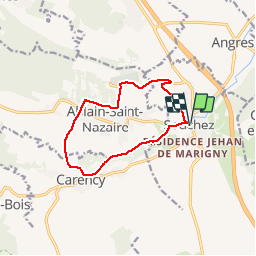
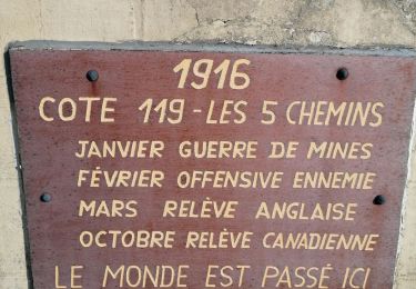
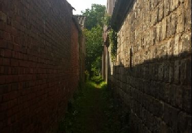
Randonnée au départ de Souchez qui monte au cimetière de Notre Dame de Lorette redescend sur Ablain St Nazaire, passe par Carency et rejoint Souchez.
Ort
Land:
France
Region :
Nordfrankreich
Abteilung/Provinz :
Pas-de-Calais
Kommune :
Souchez
Standort:
Unknown
Gehen Sie:(Dec)
Gehen Sie:(UTM)
481618 ; 5582115 (31U) N.
Kommentare
Touren in der Umgebung
![Tour Wandern Mont-Saint-Éloi - Autour du Mont-Saint-Éloi - Photo](https://media.geolcdn.com/t/375/260/ext.jpg?maxdim=2&url=https%3A%2F%2Fservices.sitytrail.com%2FGeolivesWS%2FDownloadMedia.ashx%3FTrailID%3D215199%26Media%3D15804_6.jpg)
![Wandern Wandern](https://static1.geolcdn.com/sitytour/trail-icons/101.png)
Autour du Mont-Saint-Éloi
Wandern
Schwierig
(3)
Mont-Saint-Éloi,
Nordfrankreich,
Pas-de-Calais,
France
![](/images/other/stat-length.png)
14,3 km | 16,7 km-effort
3h 34min
![](https://static1.geolcdn.com/siteimages/upload/files/16400158638029165_repeat_loop_refresh_sync_direction_icon.png)
Ja
![Tour Wandern Liévin - 50 km Lievin en nocturne - Photo](https://media.geolcdn.com/t/375/260/ext.jpg?maxdim=2&url=https%3A%2F%2Fstatic1.geolcdn.com%2Fsiteimages%2Fupload%2Ffiles%2F1553511878bg_sport_marche.png)
![Wandern Wandern](https://static1.geolcdn.com/sitytour/trail-icons/101.png)
50 km Lievin en nocturne
Wandern
Sehr schwierig
(1)
Liévin,
Nordfrankreich,
Pas-de-Calais,
France
![](/images/other/stat-length.png)
52 km | 61 km-effort
9h 0min
![](https://static1.geolcdn.com/siteimages/upload/files/16400158638029165_repeat_loop_refresh_sync_direction_icon.png)
Ja
![Tour Nordic Walking Mont-Saint-Éloi - Les trois abbayes - Photo](https://media.geolcdn.com/t/375/260/a20b48c3-4fa6-4de3-bf52-85a257498803.jpeg&format=jpg&maxdim=2)
![Nordic Walking Nordic Walking](https://static1.geolcdn.com/sitytour/trail-icons/102.png)
Les trois abbayes
Nordic Walking
Einfach
Mont-Saint-Éloi,
Nordfrankreich,
Pas-de-Calais,
France
![](/images/other/stat-length.png)
16,2 km | 18,9 km-effort
3h 24min
![](https://static1.geolcdn.com/siteimages/upload/files/16400158638029165_repeat_loop_refresh_sync_direction_icon.png)
Ja
![Tour Wandern Angres - randonnée pinchonvalles - Photo](https://media.geolcdn.com/t/375/260/b2891722-43d7-4acf-b8f9-14f5909069c3.jpg&format=jpg&maxdim=2)
![Wandern Wandern](https://static1.geolcdn.com/sitytour/trail-icons/101.png)
randonnée pinchonvalles
Wandern
Sehr schwierig
Angres,
Nordfrankreich,
Pas-de-Calais,
France
![](/images/other/stat-length.png)
27 km | 0 m-effort
3h 24min
![](https://static1.geolcdn.com/siteimages/upload/files/16400158638029165_repeat_loop_refresh_sync_direction_icon.png)
Nein
![Tour Andere Aktivitäten Liévin - boucle Liévin - Photo](https://media.geolcdn.com/t/375/260/ext.jpg?maxdim=2&url=https%3A%2F%2Fservices.sitytrail.com%2FGeolivesWS%2FDownloadMedia.ashx%3FTrailID%3D956017%26Media%3D20180429102202.jpg)
![Andere Aktivitäten Andere Aktivitäten](https://static1.geolcdn.com/sitytour/trail-icons/900.png)
boucle Liévin
Andere Aktivitäten
Sehr leicht
Liévin,
Nordfrankreich,
Pas-de-Calais,
France
![](/images/other/stat-length.png)
11 km | 12,3 km-effort
2h 2min
![](https://static1.geolcdn.com/siteimages/upload/files/16400158638029165_repeat_loop_refresh_sync_direction_icon.png)
Ja
![Tour Andere Aktivitäten Liévin - boucle Liévin - Photo](https://media.geolcdn.com/t/375/260/ext.jpg?maxdim=2&url=https%3A%2F%2Fservices.sitytrail.com%2FGeolivesWS%2FDownloadMedia.ashx%3FTrailID%3D953687%26Media%3D20180429102202.jpg)
![Andere Aktivitäten Andere Aktivitäten](https://static1.geolcdn.com/sitytour/trail-icons/900.png)
boucle Liévin
Andere Aktivitäten
Sehr leicht
Liévin,
Nordfrankreich,
Pas-de-Calais,
France
![](/images/other/stat-length.png)
11 km | 12,3 km-effort
2h 2min
![](https://static1.geolcdn.com/siteimages/upload/files/16400158638029165_repeat_loop_refresh_sync_direction_icon.png)
Ja
![Tour Laufen Aix-Noulette - aix noulette sity guide 25,3 km D530+ - Photo](https://media.geolcdn.com/t/375/260/ext.jpg?maxdim=2&url=https%3A%2F%2Fservices.sitytrail.com%2FGeolivesWS%2FDownloadMedia.ashx%3FTrailID%3D229340%26Media%3Dfix__20131027100347.jpg)
![Laufen Laufen](https://static1.geolcdn.com/sitytour/trail-icons/103.png)
aix noulette sity guide 25,3 km D530+
Laufen
Medium
Aix-Noulette,
Nordfrankreich,
Pas-de-Calais,
France
![](/images/other/stat-length.png)
23 km | 30 km-effort
2h 45min
![](https://static1.geolcdn.com/siteimages/upload/files/16400158638029165_repeat_loop_refresh_sync_direction_icon.png)
Ja
![Tour Wandern Neuville-Saint-Vaast - tour Neuville p1 - Photo](https://media.geolcdn.com/t/375/260/ext.jpg?maxdim=2&url=https%3A%2F%2Fservices.sitytrail.com%2FGeolivesWS%2FDownloadMedia.ashx%3FTrailID%3D200820%26Media%3Dfix__20130627100400.jpg)
![Wandern Wandern](https://static1.geolcdn.com/sitytour/trail-icons/101.png)
tour Neuville p1
Wandern
Einfach
Neuville-Saint-Vaast,
Nordfrankreich,
Pas-de-Calais,
France
![](/images/other/stat-length.png)
4 km | 4,5 km-effort
1h 1min
![](https://static1.geolcdn.com/siteimages/upload/files/16400158638029165_repeat_loop_refresh_sync_direction_icon.png)
Nein
![Tour Wandern Souchez - Souchez-Noulette-Lorette-Ablain - Photo](https://media.geolcdn.com/t/375/260/ext.jpg?maxdim=2&url=https%3A%2F%2Fservices.sitytrail.com%2FGeolivesWS%2FDownloadMedia.ashx%3FTrailID%3D173056%26Media%3D14580_6.jpg)
![Wandern Wandern](https://static1.geolcdn.com/sitytour/trail-icons/101.png)
Souchez-Noulette-Lorette-Ablain
Wandern
Einfach
Souchez,
Nordfrankreich,
Pas-de-Calais,
France
![](/images/other/stat-length.png)
6,7 km | 8,4 km-effort
1h 45min
![](https://static1.geolcdn.com/siteimages/upload/files/16400158638029165_repeat_loop_refresh_sync_direction_icon.png)
Ja
Belle marche Ça grimpe pour Madame surtout quand on le fait à l'envers Détour par l'anneau de la mémoire Emouvant