![](/images/other/stat-length.png)
![Tour Mountainbike Prats-de-Mollo-la-Preste - Espace VTT FFC Haut Vallespir - circuit n° 17 - Raid Transfrontalier - Photo](https://media.geolcdn.com/t/1900/400/ext.pjpeg?maxdim=2&url=https%3A%2F%2Fservices.sitytrail.com%2FGeolivesWS%2FDownloadMedia.ashx%3FTrailID%3D104355%26Media%3D7595_2.jpg)
Espace VTT FFC Haut Vallespir - circuit n° 17 - Raid Transfrontalier
tracegps
Benutzer
![Länge](/images/other/stat-length.png)
![Maximale Höhe](https://static1.geolcdn.com/siteimages/upload/files/1508320355ic_sort_altitude_max_24dp.png)
![Positive Höhendifferenz](https://static1.geolcdn.com/siteimages/upload/files/1508320355ic_sort_den_pos_24dp.png)
![Km-Effort](/images/other/stat-length.png)
![Min. Höhe](https://static1.geolcdn.com/siteimages/upload/files/1508320355ic_sort_altitude_min_24dp.png)
![Negative Höhendifferenz](https://static1.geolcdn.com/siteimages/upload/files/1508320355ic_sort_den_neg_24dp.png)
![Boucle](https://static1.geolcdn.com/siteimages/upload/files/16400158638029165_repeat_loop_refresh_sync_direction_icon.png)
![Mountainbike](https://static1.geolcdn.com/sitytour/trail-icons/202.png)
4h30
Schwierigkeit : Sehr schwierig
![Scannen Sie diesen QR-Code, um die Tour in der SityTrail-Anwendung zu öffnen](https://capi.geolives.com/qq0zvz2zws4bq2lad0pu/sitytour/trails/104355/qr.png?size=200)
Kostenlosegpshiking-Anwendung
Über SityTrail
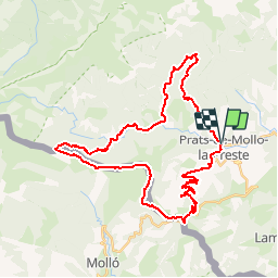
Tour Mountainbike von 41 km verfügbar auf Okzitanien, Ostpyrenäen, Prats-de-Mollo-la-Preste. Diese Tour wird von tracegps vorgeschlagen.
Beschreibung
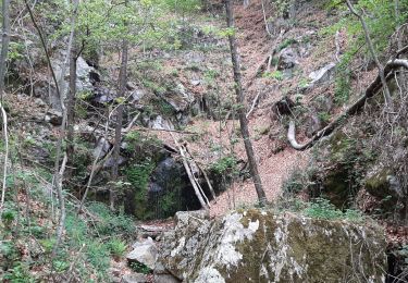
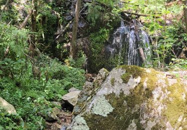
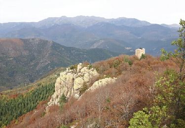
Espace VTT FFC Haut Vallespir - circuit n° 17 - Raid Transfrontalier. Circuit officiel labellisé par la Fédération Française de Cyclisme. Le circuit emblématique du site VTT. A la fois pour son coté « juge de paix » (tant au niveau physique que technique), pour son coté transfrontalier (11 km en ligne de crête coté Catalogne Sud) et pour son ambiance unique de haute montagne. Un véritable challenge à relever qui devra naturellement être réservé aux pratiquants sportifs de bon niveau. Les vététistes confirmés devront toutefois être très attentifs aux conditions météorologiques, la ligne de crête jusqu’au Col de Siern étant particulièrement exposée, en cas d’orage. Compte tenu de la longueur du parcours, il est utile de prendre en compte les différents échappatoires possibles : depuis le Col des Basses de Fabert retour par le circuit n°7 jusqu’à la Chapelle Ste-Marguerite. Ou bien, une fois arrivé à La Preste, rejoindre directement Prats-de-Mollo par la route, sans remonter dans le bassin de la Parcigoule. Ici, c’est la nature qui impose sa puissance.
Ort
Kommentare
Touren in der Umgebung
![Tour Wandern Prats-de-Mollo-la-Preste - Parts de Mollo - Photo](https://media.geolcdn.com/t/375/260/a323d879-2e3b-49e8-a319-14cd0114ee0f.jpg&format=jpg&maxdim=2)
![Wandern Wandern](https://static1.geolcdn.com/sitytour/trail-icons/101.png)
Wandern
![](/images/other/stat-length.png)
![](https://static1.geolcdn.com/siteimages/upload/files/16400158638029165_repeat_loop_refresh_sync_direction_icon.png)
![Tour Wandern Prats-de-Mollo-la-Preste - col du miracle a pratiquement de mollo - Photo](https://media.geolcdn.com/t/375/260/7083b552-6fd4-47f6-9fb0-9d75c7868b46.jpg&format=jpg&maxdim=2)
![Wandern Wandern](https://static1.geolcdn.com/sitytour/trail-icons/101.png)
Wandern
![](/images/other/stat-length.png)
![](https://static1.geolcdn.com/siteimages/upload/files/16400158638029165_repeat_loop_refresh_sync_direction_icon.png)
![Tour Wandern Le Tech - l,allau st guillem - Photo](https://media.geolcdn.com/t/375/260/1ac98370-8db2-4dc4-9697-e55bb3dbae72.jpg&format=jpg&maxdim=2)
![Wandern Wandern](https://static1.geolcdn.com/sitytour/trail-icons/101.png)
Wandern
![](/images/other/stat-length.png)
![](https://static1.geolcdn.com/siteimages/upload/files/16400158638029165_repeat_loop_refresh_sync_direction_icon.png)
![Tour Wandern Le Tech - 3 - Photo](https://media.geolcdn.com/t/375/260/5a4186bc-56e6-4a8f-a98c-1862d1fc224e.jpg&format=jpg&maxdim=2)
![Wandern Wandern](https://static1.geolcdn.com/sitytour/trail-icons/101.png)
![Tour Wandern Molló - Tour de Mir (20/9/2018) - Photo](https://media.geolcdn.com/t/375/260/ef1914cd-274d-423f-8146-4fa054ce416c.jpg&format=jpg&maxdim=2)
![Wandern Wandern](https://static1.geolcdn.com/sitytour/trail-icons/101.png)
Wandern
![](/images/other/stat-length.png)
![](https://static1.geolcdn.com/siteimages/upload/files/16400158638029165_repeat_loop_refresh_sync_direction_icon.png)
![Tour Wandern Lamanère - lamanere-coral_T - Photo](https://media.geolcdn.com/t/375/260/ext.jpg?maxdim=2&url=https%3A%2F%2Fservices.sitytrail.com%2FGeolivesWS%2FDownloadMedia.ashx%3FTrailID%3D796946%26Media%3D32ecc32a-7201-496c-b2f2-a04dfb66bd76.jpg)
![Wandern Wandern](https://static1.geolcdn.com/sitytour/trail-icons/101.png)
Wandern
![](/images/other/stat-length.png)
![](https://static1.geolcdn.com/siteimages/upload/files/16400158638029165_repeat_loop_refresh_sync_direction_icon.png)
![Tour Wandern Lamanère - Lamanere_PuigDeComaNegra_T - Photo](https://media.geolcdn.com/t/375/260/ext.jpg?maxdim=2&url=https%3A%2F%2Fservices.sitytrail.com%2FGeolivesWS%2FDownloadMedia.ashx%3FTrailID%3D788626%26Media%3D47af7e63-d3c2-468b-9f31-16c9e5afa358.jpg)
![Wandern Wandern](https://static1.geolcdn.com/sitytour/trail-icons/101.png)
Wandern
![](/images/other/stat-length.png)
![](https://static1.geolcdn.com/siteimages/upload/files/16400158638029165_repeat_loop_refresh_sync_direction_icon.png)
![Tour Wandern Lamanère - Tours de Cabrens - Photo](https://media.geolcdn.com/t/375/260/ext.jpg?maxdim=2&url=https%3A%2F%2Fservices.sitytrail.com%2FGeolivesWS%2FDownloadMedia.ashx%3FTrailID%3D655959%26Media%3Dfix__20161104114634.jpg)
![Wandern Wandern](https://static1.geolcdn.com/sitytour/trail-icons/101.png)
Wandern
![](/images/other/stat-length.png)
![](https://static1.geolcdn.com/siteimages/upload/files/16400158638029165_repeat_loop_refresh_sync_direction_icon.png)
![Tour Wandern Le Tech - Col de la roue Saint Guilhem - Photo](https://media.geolcdn.com/t/375/260/ext.jpg?maxdim=2&url=https%3A%2F%2Fservices.sitytrail.com%2FGeolivesWS%2FDownloadMedia.ashx%3FTrailID%3D420946%26Media%3Dfix__20150514141536.jpg)
![Wandern Wandern](https://static1.geolcdn.com/sitytour/trail-icons/101.png)
Wandern
![](/images/other/stat-length.png)
![](https://static1.geolcdn.com/siteimages/upload/files/16400158638029165_repeat_loop_refresh_sync_direction_icon.png)