![](/images/other/stat-length.png)
![Tour Wandern Saint-Cosme-en-Vairais - Autour de Contres - Photo](https://media.geolcdn.com/t/1900/400/ext.pjpeg?maxdim=2&url=https%3A%2F%2Fstatic1.geolcdn.com%2Fsiteimages%2Fupload%2Ffiles%2F1553511878bg_sport_marche.png)
Autour de Contres
tracegps
Benutzer
![Länge](/images/other/stat-length.png)
Länge
6,8 km
![Maximale Höhe](https://static1.geolcdn.com/siteimages/upload/files/1508320355ic_sort_altitude_max_24dp.png)
Maximale Höhe
129 m
![Positive Höhendifferenz](https://static1.geolcdn.com/siteimages/upload/files/1508320355ic_sort_den_pos_24dp.png)
Positive Höhendifferenz
81 m
![Km-Effort](/images/other/stat-length.png)
Km-Effort
7,9 km
![Min. Höhe](https://static1.geolcdn.com/siteimages/upload/files/1508320355ic_sort_altitude_min_24dp.png)
Min. Höhe
82 m
![Negative Höhendifferenz](https://static1.geolcdn.com/siteimages/upload/files/1508320355ic_sort_den_neg_24dp.png)
Negative Höhendifferenz
82 m
![Boucle](https://static1.geolcdn.com/siteimages/upload/files/16400158638029165_repeat_loop_refresh_sync_direction_icon.png)
Boucle
Ja
Erstellungsdatum :
2014-12-10 00:00:00.0
Letzte Änderung :
2014-12-10 00:00:00.0
![Wandern](https://static1.geolcdn.com/sitytour/trail-icons/101.png)
1h45
Schwierigkeit : Einfach
![Scannen Sie diesen QR-Code, um die Tour in der SityTrail-Anwendung zu öffnen](https://capi.geolives.com/qq0zvz2zws4bq2lad0pu/sitytour/trails/104305/qr.png?size=200)
Kostenlosegpshiking-Anwendung
Über SityTrail
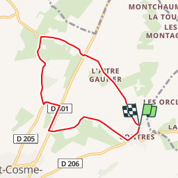
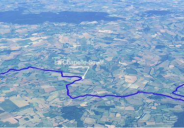
Tour Wandern von 6,8 km verfügbar auf Pays de la Loire, Sarthe, Saint-Cosme-en-Vairais. Diese Tour wird von tracegps vorgeschlagen.
Beschreibung
Ce parcours s'adresse à tout âge, il a une distance de 7 Km, il faut à pied approximativement 1 heure 45mn. Il y a quelques dénivelés, ce qui le rend plus ou moins facile suivant le sens.
Ort
Land:
France
Region :
Pays de la Loire
Abteilung/Provinz :
Sarthe
Kommune :
Saint-Cosme-en-Vairais
Standort:
Unknown
Gehen Sie:(Dec)
Gehen Sie:(UTM)
313915 ; 5350824 (31U) N.
Kommentare
Touren in der Umgebung
![Tour Wandern Igé - Traversées Percheronnes Igé - Sainte-Gauburge Via Appenai-sous-Bellême 20,5 Km - Photo](https://media.geolcdn.com/t/375/260/ext.jpg?maxdim=2&url=https%3A%2F%2Fmedia.geolcdn.com%2Ff%2Fb8a5db4a-5933-47f6-83e0-05594ae0f3f4.jpg)
![Wandern Wandern](https://static1.geolcdn.com/sitytour/trail-icons/101.png)
Traversées Percheronnes Igé - Sainte-Gauburge Via Appenai-sous-Bellême 20,5 Km
Wandern
Medium
Igé,
Normandie,
Orne,
France
![](/images/other/stat-length.png)
20 km | 24 km-effort
5h 18min
![](https://static1.geolcdn.com/siteimages/upload/files/16400158638029165_repeat_loop_refresh_sync_direction_icon.png)
Nein
![Tour Wandern Igé - Igé - Saint-Cyr-la-Rosière via Appenai-sous-Bellême 20 km - Photo](https://media.geolcdn.com/t/375/260/ext.jpg?maxdim=2&url=https%3A%2F%2Fmedia.geolcdn.com%2Ff%2F2326abe6-8d9e-4ab5-8490-bf7f8d13d643.jpg)
![Wandern Wandern](https://static1.geolcdn.com/sitytour/trail-icons/101.png)
Igé - Saint-Cyr-la-Rosière via Appenai-sous-Bellême 20 km
Wandern
Einfach
Igé,
Normandie,
Orne,
France
![](/images/other/stat-length.png)
20 km | 24 km-effort
5h 29min
![](https://static1.geolcdn.com/siteimages/upload/files/16400158638029165_repeat_loop_refresh_sync_direction_icon.png)
Nein
![Tour Wandern Igé - Igé - Prieuré de Sainte-Gauburge 18 km - Photo](https://media.geolcdn.com/t/375/260/ext.jpg?maxdim=2&url=https%3A%2F%2Fmedia.geolcdn.com%2Ff%2F5f0bf053-774b-4bac-9bb6-91c7965d4a04.png)
![Wandern Wandern](https://static1.geolcdn.com/sitytour/trail-icons/101.png)
Igé - Prieuré de Sainte-Gauburge 18 km
Wandern
Einfach
Igé,
Normandie,
Orne,
France
![](/images/other/stat-length.png)
18,4 km | 23 km-effort
7h 2min
![](https://static1.geolcdn.com/siteimages/upload/files/16400158638029165_repeat_loop_refresh_sync_direction_icon.png)
Nein
![Tour Wandern Igé - Igé - Saint-Cyr-la-Rosière 18 km - Photo](https://media.geolcdn.com/t/375/260/ext.jpg?maxdim=2&url=https%3A%2F%2Fmedia.geolcdn.com%2Ff%2F675e5d92-6adf-4873-b5b0-40a980452172.jpg)
![Wandern Wandern](https://static1.geolcdn.com/sitytour/trail-icons/101.png)
Igé - Saint-Cyr-la-Rosière 18 km
Wandern
Einfach
Igé,
Normandie,
Orne,
France
![](/images/other/stat-length.png)
18,4 km | 23 km-effort
7h 2min
![](https://static1.geolcdn.com/siteimages/upload/files/16400158638029165_repeat_loop_refresh_sync_direction_icon.png)
Nein
![Tour Wandern Igé - Igé - Saint-Germain-de-la-Coudre 13 km - Photo](https://media.geolcdn.com/t/375/260/ext.jpg?maxdim=2&url=https%3A%2F%2Fmedia.geolcdn.com%2Ff%2F01fdde33-601c-4e7b-8441-921bab75f99a.jpg)
![Wandern Wandern](https://static1.geolcdn.com/sitytour/trail-icons/101.png)
Igé - Saint-Germain-de-la-Coudre 13 km
Wandern
Medium
Igé,
Normandie,
Orne,
France
![](/images/other/stat-length.png)
12,6 km | 15 km-effort
7h 2min
![](https://static1.geolcdn.com/siteimages/upload/files/16400158638029165_repeat_loop_refresh_sync_direction_icon.png)
Nein
![Tour Wandern Igé - Igé - La Perrière 16 km - Photo](https://media.geolcdn.com/t/375/260/ext.jpg?maxdim=2&url=https%3A%2F%2Fmedia.geolcdn.com%2Ff%2F7e416307-1f21-4058-8072-c4dde45eca7f.jpg)
![Wandern Wandern](https://static1.geolcdn.com/sitytour/trail-icons/101.png)
Igé - La Perrière 16 km
Wandern
Einfach
Igé,
Normandie,
Orne,
France
![](/images/other/stat-length.png)
15,6 km | 19,6 km-effort
4h 1min
![](https://static1.geolcdn.com/siteimages/upload/files/16400158638029165_repeat_loop_refresh_sync_direction_icon.png)
Nein
![Tour Wandern Bellou-le-Trichard - Bellou le Trichard - Photo](https://media.geolcdn.com/t/375/260/ext.jpg?maxdim=2&url=https%3A%2F%2Fmedia.geolcdn.com%2Ff%2Fd730ddcd-c6fe-4fa0-bf85-c5cdf818a38f.jpg)
![Wandern Wandern](https://static1.geolcdn.com/sitytour/trail-icons/101.png)
Bellou le Trichard
Wandern
Schwierig
Bellou-le-Trichard,
Normandie,
Orne,
France
![](/images/other/stat-length.png)
10 km | 12,4 km-effort
2h 38min
![](https://static1.geolcdn.com/siteimages/upload/files/16400158638029165_repeat_loop_refresh_sync_direction_icon.png)
Ja
![Tour Auto Saint-Cosme-en-Vairais - 2024-01-31 Lonné VduP - Photo](https://media.geolcdn.com/t/375/260/ext.jpg?maxdim=2&url=https%3A%2F%2Fstatic1.geolcdn.com%2Fsiteimages%2Fupload%2Ffiles%2F15247431544x4.jpg)
![Auto Auto](https://static1.geolcdn.com/sitytour/trail-icons/401.png)
2024-01-31 Lonné VduP
Auto
Saint-Cosme-en-Vairais,
Pays de la Loire,
Sarthe,
France
![](/images/other/stat-length.png)
84 km | 95 km-effort
4h 50min
![](https://static1.geolcdn.com/siteimages/upload/files/16400158638029165_repeat_loop_refresh_sync_direction_icon.png)
Nein
![Tour Auto Igé - 2022-11-23 vdup - Photo](https://media.geolcdn.com/t/375/260/ext.jpg?maxdim=2&url=https%3A%2F%2Fstatic1.geolcdn.com%2Fsiteimages%2Fupload%2Ffiles%2F15247431544x4.jpg)
![Auto Auto](https://static1.geolcdn.com/sitytour/trail-icons/401.png)