![](/images/other/stat-length.png)
![Tour Wandern Belfahy - Le Tour de Belfahy - Photo](https://media.geolcdn.com/t/1900/400/ext.pjpeg?maxdim=2&url=https%3A%2F%2Fstatic1.geolcdn.com%2Fsiteimages%2Fupload%2Ffiles%2F1553511878bg_sport_marche.png)
Le Tour de Belfahy
tracegps
Benutzer
![Länge](/images/other/stat-length.png)
Länge
6,4 km
![Maximale Höhe](https://static1.geolcdn.com/siteimages/upload/files/1508320355ic_sort_altitude_max_24dp.png)
Maximale Höhe
942 m
![Positive Höhendifferenz](https://static1.geolcdn.com/siteimages/upload/files/1508320355ic_sort_den_pos_24dp.png)
Positive Höhendifferenz
265 m
![Km-Effort](/images/other/stat-length.png)
Km-Effort
9,9 km
![Min. Höhe](https://static1.geolcdn.com/siteimages/upload/files/1508320355ic_sort_altitude_min_24dp.png)
Min. Höhe
783 m
![Negative Höhendifferenz](https://static1.geolcdn.com/siteimages/upload/files/1508320355ic_sort_den_neg_24dp.png)
Negative Höhendifferenz
260 m
![Boucle](https://static1.geolcdn.com/siteimages/upload/files/16400158638029165_repeat_loop_refresh_sync_direction_icon.png)
Boucle
Ja
Erstellungsdatum :
2014-12-10 00:00:00.0
Letzte Änderung :
2014-12-10 00:00:00.0
![Wandern](https://static1.geolcdn.com/sitytour/trail-icons/101.png)
2h30
Schwierigkeit : Medium
![Scannen Sie diesen QR-Code, um die Tour in der SityTrail-Anwendung zu öffnen](https://capi.geolives.com/qq0zvz2zws4bq2lad0pu/sitytour/trails/104296/qr.png?size=200)
Kostenlosegpshiking-Anwendung
Über SityTrail
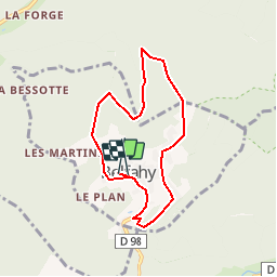
Tour Wandern von 6,4 km verfügbar auf Burgund und Freigrafschaft, Haute-Saône, Belfahy. Diese Tour wird von tracegps vorgeschlagen.
Beschreibung
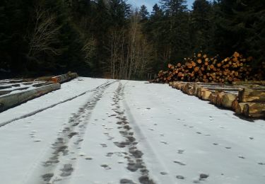
Circuit trés sympathique que nous avons effectué sous la neige en décembre. Le refuge du CBL se trouve sur le parcours, il existe egalement une auberge à Belfahy… Se garer au parking central de Belfahy
Ort
Land:
France
Region :
Burgund und Freigrafschaft
Abteilung/Provinz :
Haute-Saône
Kommune :
Belfahy
Standort:
Unknown
Gehen Sie:(Dec)
Gehen Sie:(UTM)
329975 ; 5294778 (32T) N.
Kommentare
Touren in der Umgebung
![Tour Wandern Oberassel - planche belles filles par auxelle haut - Photo](https://media.geolcdn.com/t/375/260/ext.jpg?maxdim=2&url=https%3A%2F%2Fservices.sitytrail.com%2FGeolivesWS%2FDownloadMedia.ashx%3FTrailID%3D305224%26Media%3D10d34718-818e-4b54-8a0e-bb1d508617db.JPG)
![Wandern Wandern](https://static1.geolcdn.com/sitytour/trail-icons/101.png)
planche belles filles par auxelle haut
Wandern
Medium
(3)
Oberassel,
Burgund und Freigrafschaft,
Territoire-de-Belfort,
France
![](/images/other/stat-length.png)
14,6 km | 23 km-effort
4h 55min
![](https://static1.geolcdn.com/siteimages/upload/files/16400158638029165_repeat_loop_refresh_sync_direction_icon.png)
Ja
![Tour Wandern Plancher-les-Mines - Le Ballon de Servance - Photo](https://media.geolcdn.com/t/375/260/ext.jpg?maxdim=2&url=https%3A%2F%2Fservices.sitytrail.com%2FGeolivesWS%2FDownloadMedia.ashx%3FTrailID%3D109643%26Media%3D4284_1.jpg)
![Wandern Wandern](https://static1.geolcdn.com/sitytour/trail-icons/101.png)
Le Ballon de Servance
Wandern
Schwierig
(2)
Plancher-les-Mines,
Burgund und Freigrafschaft,
Haute-Saône,
France
![](/images/other/stat-length.png)
19,7 km | 30 km-effort
6h 0min
![](https://static1.geolcdn.com/siteimages/upload/files/16400158638029165_repeat_loop_refresh_sync_direction_icon.png)
Ja
![Tour Wandern Plancher-les-Mines - 2019-08-07 Balade Plancher des belles filles - Photo](https://media.geolcdn.com/t/375/260/66a371f6-1837-4f48-9b52-0abd1c8fe413.jpg&format=jpg&maxdim=2)
![Wandern Wandern](https://static1.geolcdn.com/sitytour/trail-icons/101.png)
2019-08-07 Balade Plancher des belles filles
Wandern
Sehr leicht
Plancher-les-Mines,
Burgund und Freigrafschaft,
Haute-Saône,
France
![](/images/other/stat-length.png)
7,8 km | 11,9 km-effort
2h 12min
![](https://static1.geolcdn.com/siteimages/upload/files/16400158638029165_repeat_loop_refresh_sync_direction_icon.png)
Ja
![Tour Wandern Servance-Miellin - 2019-08-06 Marche Ballon Servance Ballon Alsace - Photo](https://media.geolcdn.com/t/375/260/452d83b8-7651-47fa-bbef-bff585b94030.jpg&format=jpg&maxdim=2)
![Wandern Wandern](https://static1.geolcdn.com/sitytour/trail-icons/101.png)
2019-08-06 Marche Ballon Servance Ballon Alsace
Wandern
Sehr schwierig
Servance-Miellin,
Burgund und Freigrafschaft,
Haute-Saône,
France
![](/images/other/stat-length.png)
19,9 km | 31 km-effort
6h 23min
![](https://static1.geolcdn.com/siteimages/upload/files/16400158638029165_repeat_loop_refresh_sync_direction_icon.png)
Ja
![Tour Wandern Plancher-les-Mines - Plancher les mines - sentier des mines - croix du choléra - Planche des Belles Filles - sentier FFI - Mont Menard - Plancher les Mines - Photo](https://media.geolcdn.com/t/375/260/f7fa7cdf-da22-406f-8d96-8f9f07e4fd3d.jpg&format=jpg&maxdim=2)
![Wandern Wandern](https://static1.geolcdn.com/sitytour/trail-icons/101.png)
Plancher les mines - sentier des mines - croix du choléra - Planche des Belle...
Wandern
Sehr schwierig
Plancher-les-Mines,
Burgund und Freigrafschaft,
Haute-Saône,
France
![](/images/other/stat-length.png)
14,3 km | 25 km-effort
5h 38min
![](https://static1.geolcdn.com/siteimages/upload/files/16400158638029165_repeat_loop_refresh_sync_direction_icon.png)
Ja
![Tour Wandern Plancher-les-Mines - Cascades de la Goutte des Saules - Belvédère - Grotte St Antoine - Photo](https://media.geolcdn.com/t/375/260/675d2d72-2ae5-41bd-abbb-b7f938827506.jpg&format=jpg&maxdim=2)
![Wandern Wandern](https://static1.geolcdn.com/sitytour/trail-icons/101.png)
Cascades de la Goutte des Saules - Belvédère - Grotte St Antoine
Wandern
Medium
Plancher-les-Mines,
Burgund und Freigrafschaft,
Haute-Saône,
France
![](/images/other/stat-length.png)
6,6 km | 11,2 km-effort
2h 32min
![](https://static1.geolcdn.com/siteimages/upload/files/16400158638029165_repeat_loop_refresh_sync_direction_icon.png)
Ja
![Tour Wandern Plancher-les-Mines - 130722 - La planche des belles - au pieds du Ballons d’Alsaces - Photo](https://media.geolcdn.com/t/375/260/63970d70-3d7a-4dbb-88a1-8a2718140e81.jpg&format=jpg&maxdim=2)
![Wandern Wandern](https://static1.geolcdn.com/sitytour/trail-icons/101.png)
130722 - La planche des belles - au pieds du Ballons d’Alsaces
Wandern
Medium
Plancher-les-Mines,
Burgund und Freigrafschaft,
Haute-Saône,
France
![](/images/other/stat-length.png)
16,5 km | 24 km-effort
3h 45min
![](https://static1.geolcdn.com/siteimages/upload/files/16400158638029165_repeat_loop_refresh_sync_direction_icon.png)
Ja
![Tour Wandern Servance-Miellin - Belfahy depuis Miellin - Photo](https://media.geolcdn.com/t/375/260/affc61f4-0ec2-4c6a-a8b6-ea7a60025d69.jpg&format=jpg&maxdim=2)
![Wandern Wandern](https://static1.geolcdn.com/sitytour/trail-icons/101.png)
Belfahy depuis Miellin
Wandern
Medium
Servance-Miellin,
Burgund und Freigrafschaft,
Haute-Saône,
France
![](/images/other/stat-length.png)
13,5 km | 21 km-effort
3h 4min
![](https://static1.geolcdn.com/siteimages/upload/files/16400158638029165_repeat_loop_refresh_sync_direction_icon.png)
Ja
![Tour Wandern Oberassel - auxelles hauts - Photo](https://media.geolcdn.com/t/375/260/11d9cee7-d94d-433f-a992-d3059a15b6fe.jpg&format=jpg&maxdim=2)
![Wandern Wandern](https://static1.geolcdn.com/sitytour/trail-icons/101.png)
auxelles hauts
Wandern
Medium
Oberassel,
Burgund und Freigrafschaft,
Territoire-de-Belfort,
France
![](/images/other/stat-length.png)
16 km | 27 km-effort
4h 20min
![](https://static1.geolcdn.com/siteimages/upload/files/16400158638029165_repeat_loop_refresh_sync_direction_icon.png)
Ja