![](/images/other/stat-length.png)
![Tour Wandern Sauveterre-de-Comminges - Balade à Sauveterre de Comminges - Photo](https://media.geolcdn.com/t/1900/400/ext.pjpeg?maxdim=2&url=https%3A%2F%2Fstatic1.geolcdn.com%2Fsiteimages%2Fupload%2Ffiles%2F1553511878bg_sport_marche.png)
Balade à Sauveterre de Comminges
tracegps
Benutzer
![Länge](/images/other/stat-length.png)
![Maximale Höhe](https://static1.geolcdn.com/siteimages/upload/files/1508320355ic_sort_altitude_max_24dp.png)
![Positive Höhendifferenz](https://static1.geolcdn.com/siteimages/upload/files/1508320355ic_sort_den_pos_24dp.png)
![Km-Effort](/images/other/stat-length.png)
![Min. Höhe](https://static1.geolcdn.com/siteimages/upload/files/1508320355ic_sort_altitude_min_24dp.png)
![Negative Höhendifferenz](https://static1.geolcdn.com/siteimages/upload/files/1508320355ic_sort_den_neg_24dp.png)
![Boucle](https://static1.geolcdn.com/siteimages/upload/files/16400158638029165_repeat_loop_refresh_sync_direction_icon.png)
![Wandern](https://static1.geolcdn.com/sitytour/trail-icons/101.png)
3h30
Schwierigkeit : Medium
![Scannen Sie diesen QR-Code, um die Tour in der SityTrail-Anwendung zu öffnen](https://capi.geolives.com/qq0zvz2zws4bq2lad0pu/sitytour/trails/104096/qr.png?size=200)
Kostenlosegpshiking-Anwendung
Über SityTrail
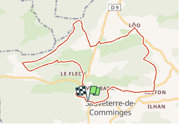
Tour Wandern von 12,1 km verfügbar auf Okzitanien, Haute-Garonne, Sauveterre-de-Comminges. Diese Tour wird von tracegps vorgeschlagen.
Beschreibung
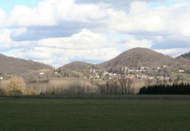
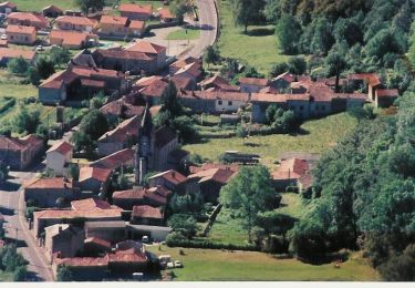
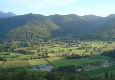
Balade qui traverses plusieurs des hameaux qui constituent Sauveterre de Comminges. De beaux points de vue sur les Pyrénées. Au cœur du Piémont Pyrénéen, sur la route départementale des 3 maréchaux : (Foch – Joffre – Galliéni,) (Valentine, Saint Béat, Val d’Aran), Sauveterre de Comminges est la commune aux onze villages nichés dans les contreforts d’un cirque verdoyant, dégageant la plaine fertile du Rieussec. Étrange communauté, unique en France où chaque village porte son propre nom, mais qui se sont réunis et assemblés sous le nom de Sauveterre, au Moyen Age, pour se protéger des envahisseurs. En 1936, pour des raisons d’identification, Sauveterre ajoutait l’appellation de son ancien comté « de Comminges ». Le mot Comminges venant du nom Convehnes, descendant lui-même du mot latin Convenarum, nom de l’ancienne région romaine qui avait pour capitale Lugdunum Convenarum (St Bertrand de Comminges). Le village de Sauveterre est dominé par une colline de 567 m sur laquelle, très naturellement, avait été construit, au moyen âge, un grand château féodal dit de Gaston Phébus. Actuellement seuls persistent un donjon carré du 11ème siècle et une chapelle (Notre- Dame) très bien restaurée et entretenue. Du haut de ce promontoire bien aménagé, les visiteurs découvrent avec surprise le superbe panorama sur le site (Source CC HautComminges).
POIs
Ort
Kommentare
Touren in der Umgebung
![Tour Wandern Ardiège - Promenade autour d'Ardiège et de Cier de Rivière - Photo](https://media.geolcdn.com/t/375/260/ext.jpg?maxdim=2&url=https%3A%2F%2Fservices.sitytrail.com%2FGeolivesWS%2FDownloadMedia.ashx%3FTrailID%3D129706%26Media%3D13248_5.jpg)
![Wandern Wandern](https://static1.geolcdn.com/sitytour/trail-icons/101.png)
Wandern
![](/images/other/stat-length.png)
![](https://static1.geolcdn.com/siteimages/upload/files/16400158638029165_repeat_loop_refresh_sync_direction_icon.png)
![Tour Wandern Barbazan - Tour de Barbazan - Photo](https://media.geolcdn.com/t/375/260/ext.jpg?maxdim=2&url=https%3A%2F%2Fservices.sitytrail.com%2FGeolivesWS%2FDownloadMedia.ashx%3FTrailID%3D129654%26Media%3D13181_3.jpg)
![Wandern Wandern](https://static1.geolcdn.com/sitytour/trail-icons/101.png)
Wandern
![](/images/other/stat-length.png)
![](https://static1.geolcdn.com/siteimages/upload/files/16400158638029165_repeat_loop_refresh_sync_direction_icon.png)
![Tour Mountainbike Sauveterre-de-Comminges - sunday spin 8/6/14 - Photo](https://media.geolcdn.com/t/375/260/ext.jpg?maxdim=2&url=https%3A%2F%2Fstatic1.geolcdn.com%2Fsiteimages%2Fupload%2Ffiles%2F1524743154velo.jpg)
![Mountainbike Mountainbike](https://static1.geolcdn.com/sitytour/trail-icons/202.png)
Mountainbike
![](/images/other/stat-length.png)
![](https://static1.geolcdn.com/siteimages/upload/files/16400158638029165_repeat_loop_refresh_sync_direction_icon.png)
![Tour Zu Fuß Barbazan - BARBAZAN le refuge saint-martin G3 Fait](https://media.geolcdn.com/t/375/260/e735875b-ff27-4605-86c7-cc5ca7ae64cd.jpg&format=jpg&maxdim=2)
![Zu Fuß Zu Fuß](https://static1.geolcdn.com/sitytour/trail-icons/100.png)
Zu Fuß
![](/images/other/stat-length.png)
![](https://static1.geolcdn.com/siteimages/upload/files/16400158638029165_repeat_loop_refresh_sync_direction_icon.png)
![Tour Wandern Cier-de-Rivière - CIER DE RIVIERE col de Couret et de l'Aouach G4 - Photo](https://media.geolcdn.com/t/375/260/3f010ee9-ba39-4904-9091-6c0fc3a6ad3f.jpg&format=jpg&maxdim=2)
![Wandern Wandern](https://static1.geolcdn.com/sitytour/trail-icons/101.png)
Wandern
![](/images/other/stat-length.png)
![](https://static1.geolcdn.com/siteimages/upload/files/16400158638029165_repeat_loop_refresh_sync_direction_icon.png)
![Tour Wandern Barbazan - de barbazan au refuge st Martin - Photo](https://media.geolcdn.com/t/375/260/ext.jpg?maxdim=2&url=https%3A%2F%2Fservices.sitytrail.com%2FGeolivesWS%2FDownloadMedia.ashx%3FTrailID%3D130338%26Media%3D20120526141847.jpg)
![Wandern Wandern](https://static1.geolcdn.com/sitytour/trail-icons/101.png)
Wandern
![](/images/other/stat-length.png)
![](https://static1.geolcdn.com/siteimages/upload/files/16400158638029165_repeat_loop_refresh_sync_direction_icon.png)
![Tour Mountainbike Barbazan - Les collines du Comminges n°16 - Barbazan - Photo](https://media.geolcdn.com/t/375/260/ext.jpg?maxdim=2&url=https%3A%2F%2Fservices.sitytrail.com%2FGeolivesWS%2FDownloadMedia.ashx%3FTrailID%3D129938%26Media%3D13495_5.jpg)
![Mountainbike Mountainbike](https://static1.geolcdn.com/sitytour/trail-icons/202.png)
Mountainbike
![](/images/other/stat-length.png)
![](https://static1.geolcdn.com/siteimages/upload/files/16400158638029165_repeat_loop_refresh_sync_direction_icon.png)
![Tour Mountainbike Bertren - Galié - Ore - Bagiry - Bertren n° 12 - Bertren - Photo](https://media.geolcdn.com/t/375/260/ext.jpg?maxdim=2&url=https%3A%2F%2Fservices.sitytrail.com%2FGeolivesWS%2FDownloadMedia.ashx%3FTrailID%3D129937%26Media%3D13494_5.jpg)
![Mountainbike Mountainbike](https://static1.geolcdn.com/sitytour/trail-icons/202.png)
Mountainbike
![](/images/other/stat-length.png)
![](https://static1.geolcdn.com/siteimages/upload/files/16400158638029165_repeat_loop_refresh_sync_direction_icon.png)
![Tour Mountainbike Sauveterre-de-Comminges - Le tour du Barry - Sauveterre de Comminges - Photo](https://media.geolcdn.com/t/375/260/ext.jpg?maxdim=2&url=https%3A%2F%2Fservices.sitytrail.com%2FGeolivesWS%2FDownloadMedia.ashx%3FTrailID%3D129871%26Media%3D13436_4.jpg)
![Mountainbike Mountainbike](https://static1.geolcdn.com/sitytour/trail-icons/202.png)
Mountainbike
![](/images/other/stat-length.png)
![](https://static1.geolcdn.com/siteimages/upload/files/16400158638029165_repeat_loop_refresh_sync_direction_icon.png)