![](/images/other/stat-length.png)
![Tour Wandern Saint-Julien-du-Pinet - Boucle Glavenas - Corboeuf- Glavenas - Photo](https://media.geolcdn.com/t/1900/400/ext.pjpeg?maxdim=2&url=https%3A%2F%2Fstatic1.geolcdn.com%2Fsiteimages%2Fupload%2Ffiles%2F1553511878bg_sport_marche.png)
Boucle Glavenas - Corboeuf- Glavenas
phcol
Benutzer
![Länge](/images/other/stat-length.png)
Länge
15,9 km
![Maximale Höhe](https://static1.geolcdn.com/siteimages/upload/files/1508320355ic_sort_altitude_max_24dp.png)
Maximale Höhe
989 m
![Positive Höhendifferenz](https://static1.geolcdn.com/siteimages/upload/files/1508320355ic_sort_den_pos_24dp.png)
Positive Höhendifferenz
406 m
![Km-Effort](/images/other/stat-length.png)
Km-Effort
21 km
![Min. Höhe](https://static1.geolcdn.com/siteimages/upload/files/1508320355ic_sort_altitude_min_24dp.png)
Min. Höhe
686 m
![Negative Höhendifferenz](https://static1.geolcdn.com/siteimages/upload/files/1508320355ic_sort_den_neg_24dp.png)
Negative Höhendifferenz
400 m
![Boucle](https://static1.geolcdn.com/siteimages/upload/files/16400158638029165_repeat_loop_refresh_sync_direction_icon.png)
Boucle
Ja
Erstellungsdatum :
2019-01-15 16:13:54.525
Letzte Änderung :
2019-01-15 16:13:54.525
![Wandern](https://static1.geolcdn.com/sitytour/trail-icons/101.png)
4h32
Schwierigkeit : Medium
![Scannen Sie diesen QR-Code, um die Tour in der SityTrail-Anwendung zu öffnen](https://capi.geolives.com/qq0zvz2zws4bq2lad0pu/sitytour/trails/1039792/qr.png?size=200)
Kostenlosegpshiking-Anwendung
Über SityTrail
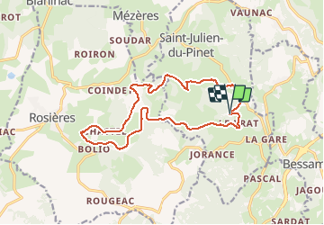
Tour Wandern von 15,9 km verfügbar auf Auvergne-Rhone-Alpen, Haute-Loire, Saint-Julien-du-Pinet. Diese Tour wird von phcol vorgeschlagen.
Beschreibung
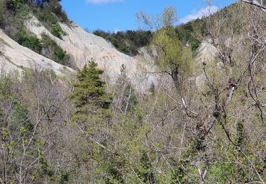
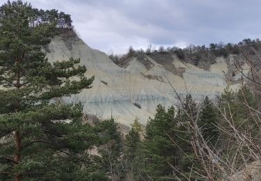
Boucle qui emprunte le tracé de la Galoche jusqu'au ravin de Corboeuf.
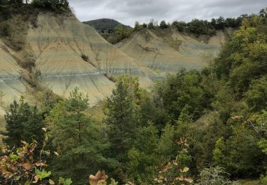
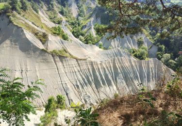
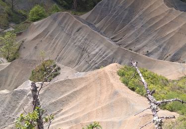
Passage à proximité du moulin de Pinard.
Ort
Land:
France
Region :
Auvergne-Rhone-Alpen
Abteilung/Provinz :
Haute-Loire
Kommune :
Saint-Julien-du-Pinet
Standort:
Unknown
Gehen Sie:(Dec)
Gehen Sie:(UTM)
582955 ; 4998304 (31T) N.
Kommentare
Touren in der Umgebung
![Tour Wandern Rosières - 20201005 ravin de Corboeuf - Photo](https://media.geolcdn.com/t/375/260/ext.jpg?maxdim=2&url=https%3A%2F%2Fmedia.geolcdn.com%2Ff%2Fe8872610-c905-491d-8202-3cc1b4362bb4.jpg)
![Wandern Wandern](https://static1.geolcdn.com/sitytour/trail-icons/101.png)
20201005 ravin de Corboeuf
Wandern
Einfach
(1)
Rosières,
Auvergne-Rhone-Alpen,
Haute-Loire,
France
![](/images/other/stat-length.png)
3,7 km | 5,4 km-effort
52min
![](https://static1.geolcdn.com/siteimages/upload/files/16400158638029165_repeat_loop_refresh_sync_direction_icon.png)
Ja
![Tour Wandern Rosières - 2020-02-21 13:18:03 Chronomètre - Photo](https://media.geolcdn.com/t/375/260/ext.jpg?maxdim=2&url=https%3A%2F%2Fmedia.geolcdn.com%2Ff%2F5c7b5bc7-cf98-4ad1-994b-e5103b9d44e9.jpg)
![Wandern Wandern](https://static1.geolcdn.com/sitytour/trail-icons/101.png)
2020-02-21 13:18:03 Chronomètre
Wandern
Sehr schwierig
Rosières,
Auvergne-Rhone-Alpen,
Haute-Loire,
France
![](/images/other/stat-length.png)
16,8 km | 26 km-effort
5h 25min
![](https://static1.geolcdn.com/siteimages/upload/files/16400158638029165_repeat_loop_refresh_sync_direction_icon.png)
Ja
![Tour Wandern Rosières - Rosières 43 - Photo](https://media.geolcdn.com/t/375/260/ext.jpg?maxdim=2&url=https%3A%2F%2Fservices.sitytrail.com%2FGeolivesWS%2FDownloadMedia.ashx%3FTrailID%3D1057359%26Media%3Dfix__20181015145437.jpg)
![Wandern Wandern](https://static1.geolcdn.com/sitytour/trail-icons/101.png)
Rosières 43
Wandern
Sehr leicht
Rosières,
Auvergne-Rhone-Alpen,
Haute-Loire,
France
![](/images/other/stat-length.png)
10,7 km | 13,7 km-effort
2h 56min
![](https://static1.geolcdn.com/siteimages/upload/files/16400158638029165_repeat_loop_refresh_sync_direction_icon.png)
Ja
![Tour Wandern Saint-Étienne-Lardeyrol - La Huche Plate - Lachaud de Rougeac - Photo](https://media.geolcdn.com/t/375/260/ext.jpg?maxdim=2&url=https%3A%2F%2Fservices.sitytrail.com%2FGeolivesWS%2FDownloadMedia.ashx%3FTrailID%3D129775%26Media%3D13318_6.jpg)
![Wandern Wandern](https://static1.geolcdn.com/sitytour/trail-icons/101.png)
La Huche Plate - Lachaud de Rougeac
Wandern
Medium
Saint-Étienne-Lardeyrol,
Auvergne-Rhone-Alpen,
Haute-Loire,
France
![](/images/other/stat-length.png)
8,9 km | 12,2 km-effort
2h 30min
![](https://static1.geolcdn.com/siteimages/upload/files/16400158638029165_repeat_loop_refresh_sync_direction_icon.png)
Ja
![Tour Wandern Rosières - Ravin de Corboeuf - Photo](https://media.geolcdn.com/t/375/260/ext.jpg?maxdim=2&url=https%3A%2F%2Fmedia.geolcdn.com%2Ff%2F24a2d4cb-8c2c-414e-9512-e46c685db413.jpg)
![Wandern Wandern](https://static1.geolcdn.com/sitytour/trail-icons/101.png)
Ravin de Corboeuf
Wandern
Sehr leicht
Rosières,
Auvergne-Rhone-Alpen,
Haute-Loire,
France
![](/images/other/stat-length.png)
3,9 km | 5,6 km-effort
1h 8min
![](https://static1.geolcdn.com/siteimages/upload/files/16400158638029165_repeat_loop_refresh_sync_direction_icon.png)
Ja
![Tour Wandern Rosières - Ravin de Corboeuf et la galoche - Photo](https://media.geolcdn.com/t/375/260/ext.jpg?maxdim=2&url=https%3A%2F%2Fmedia.geolcdn.com%2Ff%2F2949fbe4-46da-4466-968a-3e549c3c51cc.jpg)
![Wandern Wandern](https://static1.geolcdn.com/sitytour/trail-icons/101.png)
Ravin de Corboeuf et la galoche
Wandern
Medium
(1)
Rosières,
Auvergne-Rhone-Alpen,
Haute-Loire,
France
![](/images/other/stat-length.png)
10,3 km | 13,3 km-effort
5h 27min
![](https://static1.geolcdn.com/siteimages/upload/files/16400158638029165_repeat_loop_refresh_sync_direction_icon.png)
Ja
![Tour Wandern Rosières - la Galoche et le ravin de Corboeuf - Photo](https://media.geolcdn.com/t/375/260/ext.jpg?maxdim=2&url=https%3A%2F%2Fmedia.geolcdn.com%2Ff%2F2f5414d2-5634-497b-ba4a-fc14972ae22d.jpg)
![Wandern Wandern](https://static1.geolcdn.com/sitytour/trail-icons/101.png)
la Galoche et le ravin de Corboeuf
Wandern
Einfach
(1)
Rosières,
Auvergne-Rhone-Alpen,
Haute-Loire,
France
![](/images/other/stat-length.png)
10,9 km | 14,6 km-effort
3h 17min
![](https://static1.geolcdn.com/siteimages/upload/files/16400158638029165_repeat_loop_refresh_sync_direction_icon.png)
Nein
![Tour Wandern Rosières - Le ravin du coeurboeuf - Photo](https://media.geolcdn.com/t/375/260/ext.jpg?maxdim=2&url=https%3A%2F%2Fmedia.geolcdn.com%2Ff%2Fc912b676-8d8c-430a-a1f9-27830de3d02b.jpg)
![Wandern Wandern](https://static1.geolcdn.com/sitytour/trail-icons/101.png)
Le ravin du coeurboeuf
Wandern
Einfach
Rosières,
Auvergne-Rhone-Alpen,
Haute-Loire,
France
![](/images/other/stat-length.png)
3,4 km | 5 km-effort
1h 34min
![](https://static1.geolcdn.com/siteimages/upload/files/16400158638029165_repeat_loop_refresh_sync_direction_icon.png)
Ja
![Tour Wandern Rosières - Tour du mont Jalore via Roiron - Photo](https://media.geolcdn.com/t/375/260/ext.jpg?maxdim=2&url=https%3A%2F%2Fmedia.geolcdn.com%2Ff%2F1e5b93ef-3762-4007-a1a0-045e81222186.jpg)
![Wandern Wandern](https://static1.geolcdn.com/sitytour/trail-icons/101.png)
Tour du mont Jalore via Roiron
Wandern
Medium
Rosières,
Auvergne-Rhone-Alpen,
Haute-Loire,
France
![](/images/other/stat-length.png)
6,8 km | 10 km-effort
1h 49min
![](https://static1.geolcdn.com/siteimages/upload/files/16400158638029165_repeat_loop_refresh_sync_direction_icon.png)
Ja