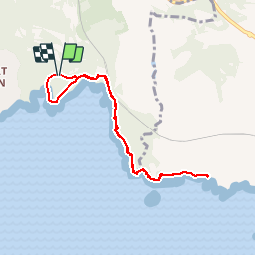
![](/images/other/stat-length.png)
![Tour Wandern Saint-Cyr-sur-Mer - Port d'Alon - Bandol - Port d'Alon - Photo](https://media.geolcdn.com/t/1900/400/ext.pjpeg?maxdim=2&url=https%3A%2F%2Fservices.sitytrail.com%2FGeolivesWS%2FDownloadMedia.ashx%3FTrailID%3D103920%26Media%3D6771_1.jpg)
Port d'Alon - Bandol - Port d'Alon
tracegps
Benutzer
![Länge](/images/other/stat-length.png)
![Maximale Höhe](https://static1.geolcdn.com/siteimages/upload/files/1508320355ic_sort_altitude_max_24dp.png)
![Positive Höhendifferenz](https://static1.geolcdn.com/siteimages/upload/files/1508320355ic_sort_den_pos_24dp.png)
![Km-Effort](/images/other/stat-length.png)
![Min. Höhe](https://static1.geolcdn.com/siteimages/upload/files/1508320355ic_sort_altitude_min_24dp.png)
![Negative Höhendifferenz](https://static1.geolcdn.com/siteimages/upload/files/1508320355ic_sort_den_neg_24dp.png)
![Boucle](https://static1.geolcdn.com/siteimages/upload/files/16400158638029165_repeat_loop_refresh_sync_direction_icon.png)
![Wandern](https://static1.geolcdn.com/sitytour/trail-icons/101.png)
2h00
Schwierigkeit : Medium
![Scannen Sie diesen QR-Code, um die Tour in der SityTrail-Anwendung zu öffnen](https://capi.geolives.com/qq0zvz2zws4bq2lad0pu/sitytour/trails/103920/qr.png?size=200)
Kostenlosegpshiking-Anwendung
Über SityTrail
Tour Wandern von 7,7 km verfügbar auf Provence-Alpes-Côte d'Azur, Var, Saint-Cyr-sur-Mer. Diese Tour wird von tracegps vorgeschlagen.
Beschreibung
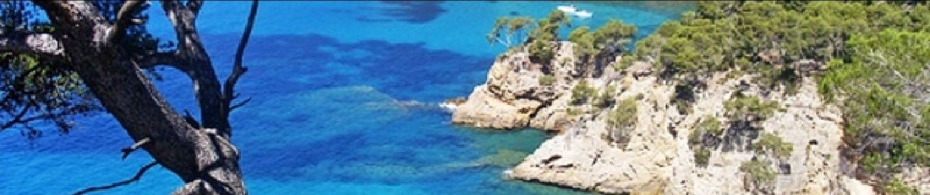
Très belle randonnée de niveau 3. Vous pourrez vous garer au point de départ (payant en juillet et aout). Vous marcherez sur le chemin du littoral balisé en jaune. Ce chemin est ombragé et suit la cote. Il est parfois pierreux et certaines parties sont en escalier. Vous pourrez profiter de magnifiques points de vue sur la mer et pourquoi pas profiter des plages pour vous baigner. Retrouvez d’autres informations sur le site de Rando Loisirs à Carnoux en Provence.
Ort
Kommentare
Touren in der Umgebung
![Tour Wandern Bandol - SityTrail - fregate - Photo](https://media.geolcdn.com/t/375/260/2853a075-1e77-4b06-bf33-9c03418a8afd.jpg&format=jpg&maxdim=2)
![Wandern Wandern](https://static1.geolcdn.com/sitytour/trail-icons/101.png)
Wandern
![](/images/other/stat-length.png)
![](https://static1.geolcdn.com/siteimages/upload/files/16400158638029165_repeat_loop_refresh_sync_direction_icon.png)
![Tour Wandern Bandol - SityTrail - Tour du golf de la Fregate (version longue ) - Photo](https://media.geolcdn.com/t/375/260/53cbdef8-8c49-42e8-bcb8-017960282ccb.jpg&format=jpg&maxdim=2)
![Wandern Wandern](https://static1.geolcdn.com/sitytour/trail-icons/101.png)
Wandern
![](/images/other/stat-length.png)
![](https://static1.geolcdn.com/siteimages/upload/files/16400158638029165_repeat_loop_refresh_sync_direction_icon.png)
![Tour Wandern Saint-Cyr-sur-Mer - St Cyr - Bandol - Photo](https://media.geolcdn.com/t/375/260/ext.jpg?maxdim=2&url=https%3A%2F%2Fservices.sitytrail.com%2FGeolivesWS%2FDownloadMedia.ashx%3FTrailID%3D746530%26Media%3Dfix__20170505150639.jpg)
![Wandern Wandern](https://static1.geolcdn.com/sitytour/trail-icons/101.png)
Wandern
![](/images/other/stat-length.png)
![](https://static1.geolcdn.com/siteimages/upload/files/16400158638029165_repeat_loop_refresh_sync_direction_icon.png)
![Tour Wandern Saint-Cyr-sur-Mer - Le Port d'Alon - Photo](https://media.geolcdn.com/t/375/260/ext.jpg?maxdim=2&url=https%3A%2F%2Fservices.sitytrail.com%2FGeolivesWS%2FDownloadMedia.ashx%3FTrailID%3D103916%26Media%3D6764_1.jpg)
![Wandern Wandern](https://static1.geolcdn.com/sitytour/trail-icons/101.png)
Wandern
![](/images/other/stat-length.png)
![](https://static1.geolcdn.com/siteimages/upload/files/16400158638029165_repeat_loop_refresh_sync_direction_icon.png)
![Tour Wandern Bandol - Rando Bandol - Port d'Alon - Bandol - Photo](https://media.geolcdn.com/t/375/260/ext.jpg?maxdim=2&url=https%3A%2F%2Fservices.sitytrail.com%2FGeolivesWS%2FDownloadMedia.ashx%3FTrailID%3D103781%26Media%3D6551_1.jpg)
![Wandern Wandern](https://static1.geolcdn.com/sitytour/trail-icons/101.png)
Wandern
![](/images/other/stat-length.png)
![](https://static1.geolcdn.com/siteimages/upload/files/16400158638029165_repeat_loop_refresh_sync_direction_icon.png)
![Tour Zu Fuß Saint-Cyr-sur-Mer - Sentier du littoral (Saint-Cyr-sur-Mer) - Photo](https://media.geolcdn.com/t/375/260/92755a25-0a9e-442f-9ac8-e799adb59b27.jpeg&format=jpg&maxdim=2)
![Zu Fuß Zu Fuß](https://static1.geolcdn.com/sitytour/trail-icons/100.png)
Zu Fuß
![](/images/other/stat-length.png)
![](https://static1.geolcdn.com/siteimages/upload/files/16400158638029165_repeat_loop_refresh_sync_direction_icon.png)
![Tour Wandern Bandol - SityTrail - Boucle Bandol - Port d'Alon - Dune de sable - La Madrague - Port d'Alon - Bandol - Photo](https://media.geolcdn.com/t/375/260/ext.jpg?maxdim=2&url=https%3A%2F%2Fstatic1.geolcdn.com%2Fsiteimages%2Fupload%2Ffiles%2F1553511878bg_sport_marche.png)
![Wandern Wandern](https://static1.geolcdn.com/sitytour/trail-icons/101.png)
Wandern
![](/images/other/stat-length.png)
![](https://static1.geolcdn.com/siteimages/upload/files/16400158638029165_repeat_loop_refresh_sync_direction_icon.png)
![Tour Wandern Bandol - bandol baie des nations - Photo](https://media.geolcdn.com/t/375/260/5d08df52-a469-4cdd-a3c1-851cbb01cef5.jpg&format=jpg&maxdim=2)
![Wandern Wandern](https://static1.geolcdn.com/sitytour/trail-icons/101.png)
Wandern
![](/images/other/stat-length.png)
![](https://static1.geolcdn.com/siteimages/upload/files/16400158638029165_repeat_loop_refresh_sync_direction_icon.png)
![Tour Wandern Saint-Cyr-sur-Mer - le sentier littoral de la Madrague et la colline de sable - Photo](https://media.geolcdn.com/t/375/260/ext.jpg?maxdim=2&url=https%3A%2F%2Fservices.sitytrail.com%2FGeolivesWS%2FDownloadMedia.ashx%3FTrailID%3D485513%26Media%3D21ba94d9-fd64-486b-9460-9884fbc5235d.JPG)
![Wandern Wandern](https://static1.geolcdn.com/sitytour/trail-icons/101.png)
Wandern
![](/images/other/stat-length.png)
![](https://static1.geolcdn.com/siteimages/upload/files/16400158638029165_repeat_loop_refresh_sync_direction_icon.png)
tres beau parcours facile niveau 2