![](/images/other/stat-length.png)
![Tour Mountainbike La Ferté-Saint-Aubin - La Ferté St Anbin - Vouzon - Photo](https://media.geolcdn.com/t/1900/400/ext.pjpeg?maxdim=2&url=https%3A%2F%2Fservices.sitytrail.com%2FGeolivesWS%2FDownloadMedia.ashx%3FTrailID%3D103899%26Media%3D6725_3.jpg)
La Ferté St Anbin - Vouzon
tracegps
Benutzer
![Länge](/images/other/stat-length.png)
Länge
37 km
![Maximale Höhe](https://static1.geolcdn.com/siteimages/upload/files/1508320355ic_sort_altitude_max_24dp.png)
Maximale Höhe
155 m
![Positive Höhendifferenz](https://static1.geolcdn.com/siteimages/upload/files/1508320355ic_sort_den_pos_24dp.png)
Positive Höhendifferenz
298 m
![Km-Effort](/images/other/stat-length.png)
Km-Effort
40 km
![Min. Höhe](https://static1.geolcdn.com/siteimages/upload/files/1508320355ic_sort_altitude_min_24dp.png)
Min. Höhe
100 m
![Negative Höhendifferenz](https://static1.geolcdn.com/siteimages/upload/files/1508320355ic_sort_den_neg_24dp.png)
Negative Höhendifferenz
293 m
![Boucle](https://static1.geolcdn.com/siteimages/upload/files/16400158638029165_repeat_loop_refresh_sync_direction_icon.png)
Boucle
Ja
Erstellungsdatum :
2014-12-10 00:00:00.0
Letzte Änderung :
2014-12-10 00:00:00.0
![Mountainbike](https://static1.geolcdn.com/sitytour/trail-icons/202.png)
3h00
Schwierigkeit : Medium
![Scannen Sie diesen QR-Code, um die Tour in der SityTrail-Anwendung zu öffnen](https://capi.geolives.com/qq0zvz2zws4bq2lad0pu/sitytour/trails/103899/qr.png?size=200)
Kostenlosegpshiking-Anwendung
Über SityTrail
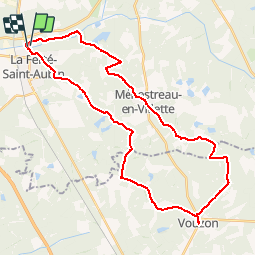
Tour Mountainbike von 37 km verfügbar auf Zentrum-Loiretal, Loiret, La Ferté-Saint-Aubin. Diese Tour wird von tracegps vorgeschlagen.
Beschreibung
Départ du parking du château de la Ferté Saint Aubin vers Vouzon par les GR de Sologne et retour par Ménestreau en Villette et la rive du Cosson.
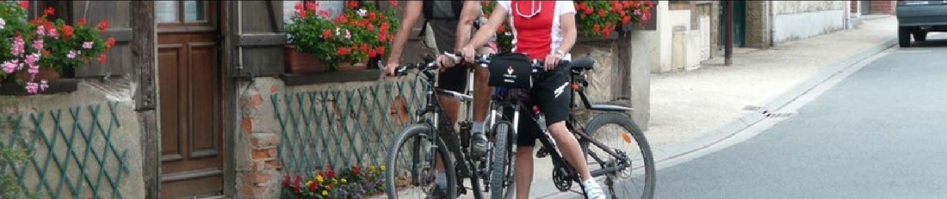
Ort
Land:
France
Region :
Zentrum-Loiretal
Abteilung/Provinz :
Loiret
Kommune :
La Ferté-Saint-Aubin
Standort:
Unknown
Gehen Sie:(Dec)
Gehen Sie:(UTM)
420685 ; 5286415 (31T) N.
Kommentare
Touren in der Umgebung
![Tour Mountainbike La Ferté-Saint-Aubin - La ferté - Yvoy le marron - Photo](https://media.geolcdn.com/t/375/260/ext.jpg?maxdim=2&url=https%3A%2F%2Fservices.sitytrail.com%2FGeolivesWS%2FDownloadMedia.ashx%3FTrailID%3D722694%26Media%3D20170329165819.jpg)
![Mountainbike Mountainbike](https://static1.geolcdn.com/sitytour/trail-icons/202.png)
La ferté - Yvoy le marron
Mountainbike
Einfach
La Ferté-Saint-Aubin,
Zentrum-Loiretal,
Loiret,
France
![](/images/other/stat-length.png)
23 km | 26 km-effort
2h 23min
![](https://static1.geolcdn.com/siteimages/upload/files/16400158638029165_repeat_loop_refresh_sync_direction_icon.png)
Ja
![Tour Wandern La Ferté-Saint-Aubin - LA FERTE ST AUBIN - Photo](https://media.geolcdn.com/t/375/260/ext.jpg?maxdim=2&url=https%3A%2F%2Fstatic1.geolcdn.com%2Fsiteimages%2Fupload%2Ffiles%2F1553511878bg_sport_marche.png)
![Wandern Wandern](https://static1.geolcdn.com/sitytour/trail-icons/101.png)
LA FERTE ST AUBIN
Wandern
Sehr leicht
La Ferté-Saint-Aubin,
Zentrum-Loiretal,
Loiret,
France
![](/images/other/stat-length.png)
7,5 km | 8,3 km-effort
1h 50min
![](https://static1.geolcdn.com/siteimages/upload/files/16400158638029165_repeat_loop_refresh_sync_direction_icon.png)
Ja
![Tour Hybrid-Bike La Ferté-Saint-Aubin - De la Ferté St aubin à Mézières lez Cléry - Photo](https://media.geolcdn.com/t/375/260/ext.jpg?maxdim=2&url=https%3A%2F%2Fstatic1.geolcdn.com%2Fsiteimages%2Fupload%2Ffiles%2F1524743154velo.jpg)
![Hybrid-Bike Hybrid-Bike](https://static1.geolcdn.com/sitytour/trail-icons/203.png)
De la Ferté St aubin à Mézières lez Cléry
Hybrid-Bike
Einfach
La Ferté-Saint-Aubin,
Zentrum-Loiretal,
Loiret,
France
![](/images/other/stat-length.png)
19,1 km | 21 km-effort
2h 3min
![](https://static1.geolcdn.com/siteimages/upload/files/16400158638029165_repeat_loop_refresh_sync_direction_icon.png)
Nein
![Tour Mountainbike La Ferté-Saint-Aubin - VTT 36km La Ferté Chaumont Yvoy - Photo](https://media.geolcdn.com/t/375/260/ext.jpg?maxdim=2&url=https%3A%2F%2Fstatic1.geolcdn.com%2Fsiteimages%2Fupload%2Ffiles%2F1524743154velo.jpg)
![Mountainbike Mountainbike](https://static1.geolcdn.com/sitytour/trail-icons/202.png)
VTT 36km La Ferté Chaumont Yvoy
Mountainbike
Sehr leicht
La Ferté-Saint-Aubin,
Zentrum-Loiretal,
Loiret,
France
![](/images/other/stat-length.png)
36 km | 40 km-effort
2h 49min
![](https://static1.geolcdn.com/siteimages/upload/files/16400158638029165_repeat_loop_refresh_sync_direction_icon.png)
Ja
![Tour Wandern La Ferté-Saint-Aubin - La Ferté-Saint -Aubin PR du Mazuray - Photo](https://media.geolcdn.com/t/375/260/ext.jpg?maxdim=2&url=https%3A%2F%2Fstatic1.geolcdn.com%2Fsiteimages%2Fupload%2Ffiles%2F1553511878bg_sport_marche.png)
![Wandern Wandern](https://static1.geolcdn.com/sitytour/trail-icons/101.png)
La Ferté-Saint -Aubin PR du Mazuray
Wandern
Einfach
La Ferté-Saint-Aubin,
Zentrum-Loiretal,
Loiret,
France
![](/images/other/stat-length.png)
12,5 km | 13,9 km-effort
3h 3min
![](https://static1.geolcdn.com/siteimages/upload/files/16400158638029165_repeat_loop_refresh_sync_direction_icon.png)
Ja
![Tour Mountainbike La Ferté-Saint-Aubin - 2010-09-19 LFSA - Lamothe Beuvron - Photo](https://media.geolcdn.com/t/375/260/ext.jpg?maxdim=2&url=https%3A%2F%2Fstatic1.geolcdn.com%2Fsiteimages%2Fupload%2Ffiles%2F1524743154velo.jpg)
![Mountainbike Mountainbike](https://static1.geolcdn.com/sitytour/trail-icons/202.png)
2010-09-19 LFSA - Lamothe Beuvron
Mountainbike
Sehr leicht
La Ferté-Saint-Aubin,
Zentrum-Loiretal,
Loiret,
France
![](/images/other/stat-length.png)
51 km | 57 km-effort
Unbekannt
![](https://static1.geolcdn.com/siteimages/upload/files/16400158638029165_repeat_loop_refresh_sync_direction_icon.png)
Ja
![Tour Wandern La Ferté-Saint-Aubin - la fierté menestreau - Photo](https://media.geolcdn.com/t/375/260/ext.jpg?maxdim=2&url=https%3A%2F%2Fstatic1.geolcdn.com%2Fsiteimages%2Fupload%2Ffiles%2F1553511878bg_sport_marche.png)
![Wandern Wandern](https://static1.geolcdn.com/sitytour/trail-icons/101.png)
la fierté menestreau
Wandern
Schwierig
La Ferté-Saint-Aubin,
Zentrum-Loiretal,
Loiret,
France
![](/images/other/stat-length.png)
12,5 km | 13,8 km-effort
2h 29min
![](https://static1.geolcdn.com/siteimages/upload/files/16400158638029165_repeat_loop_refresh_sync_direction_icon.png)
Ja
![Tour Wandern La Ferté-Saint-Aubin - la lumière route des traues - Photo](https://media.geolcdn.com/t/375/260/ext.jpg?maxdim=2&url=https%3A%2F%2Fstatic1.geolcdn.com%2Fsiteimages%2Fupload%2Ffiles%2F1553511878bg_sport_marche.png)
![Wandern Wandern](https://static1.geolcdn.com/sitytour/trail-icons/101.png)
la lumière route des traues
Wandern
Sehr leicht
La Ferté-Saint-Aubin,
Zentrum-Loiretal,
Loiret,
France
![](/images/other/stat-length.png)
10,5 km | 11,9 km-effort
2h 12min
![](https://static1.geolcdn.com/siteimages/upload/files/16400158638029165_repeat_loop_refresh_sync_direction_icon.png)
Ja
![Tour Wandern La Ferté-Saint-Aubin - les trays - Photo](https://media.geolcdn.com/t/375/260/ext.jpg?maxdim=2&url=https%3A%2F%2Fstatic1.geolcdn.com%2Fsiteimages%2Fupload%2Ffiles%2F1553511878bg_sport_marche.png)
![Wandern Wandern](https://static1.geolcdn.com/sitytour/trail-icons/101.png)
les trays
Wandern
Einfach
La Ferté-Saint-Aubin,
Zentrum-Loiretal,
Loiret,
France
![](/images/other/stat-length.png)
11,6 km | 12,6 km-effort
2h 7min
![](https://static1.geolcdn.com/siteimages/upload/files/16400158638029165_repeat_loop_refresh_sync_direction_icon.png)
Ja