![](/images/other/stat-length.png)
![Tour Wandern Murat - Col de la Molède - Photo](https://media.geolcdn.com/t/1900/400/ext.pjpeg?maxdim=2&url=https%3A%2F%2Fservices.sitytrail.com%2FGeolivesWS%2FDownloadMedia.ashx%3FTrailID%3D103725%26Media%3D6386_2.jpg)
Col de la Molède
tracegps
Benutzer
![Länge](/images/other/stat-length.png)
![Maximale Höhe](https://static1.geolcdn.com/siteimages/upload/files/1508320355ic_sort_altitude_max_24dp.png)
![Positive Höhendifferenz](https://static1.geolcdn.com/siteimages/upload/files/1508320355ic_sort_den_pos_24dp.png)
![Km-Effort](/images/other/stat-length.png)
![Min. Höhe](https://static1.geolcdn.com/siteimages/upload/files/1508320355ic_sort_altitude_min_24dp.png)
![Negative Höhendifferenz](https://static1.geolcdn.com/siteimages/upload/files/1508320355ic_sort_den_neg_24dp.png)
![Boucle](https://static1.geolcdn.com/siteimages/upload/files/16400158638029165_repeat_loop_refresh_sync_direction_icon.png)
![Wandern](https://static1.geolcdn.com/sitytour/trail-icons/101.png)
5h00
Schwierigkeit : Schwierig
![Scannen Sie diesen QR-Code, um die Tour in der SityTrail-Anwendung zu öffnen](https://capi.geolives.com/qq0zvz2zws4bq2lad0pu/sitytour/trails/103725/qr.png?size=200)
Kostenlosegpshiking-Anwendung
Über SityTrail
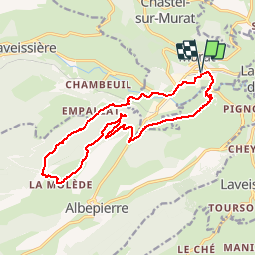
Tour Wandern von 16,9 km verfügbar auf Auvergne-Rhone-Alpen, Cantal, Murat. Diese Tour wird von tracegps vorgeschlagen.
Beschreibung
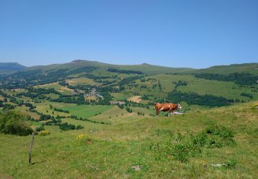
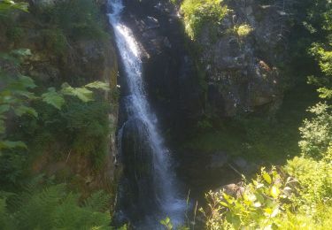
Randonnée au cœur de la Haute Auvergne. Départ à Murat, devant la gare SNCF. Avant la montée vers l’église prieurale de Bredons, voir le vieux pont sur la rivière Alagnon. L’église, site Clunisien, renferme un remarquable retable monumental de 1710. Après la traversée du CD39, on grimpe jusqu’au plateau des Cunes, siège d’anciennes carrières de Trachyandésite d’où furent extraites les pierres de taille des vieilles maisons de Murat et alentours. Au col de la Molède (mot d’origine celtique : mol signifie hauteur), larges vues sur les crêtes du plomb du Cantal et le village d’Albepierre. L’itinéraire de retour traverse la forêt domaniale de Murat, ancienne forêt de la vicomté de Murat rattachée à la couronne en 1531. Note : dans l’édition 2006 du topo-guide Volcan cantalien de Chamina, le tracé de l’itinéraire sur la carte est décalé d’environ 500 mètres vers l’Ouest…
Ort
Kommentare
Touren in der Umgebung
![Tour Wandern Dienne - Cantal - le Chaumeil - Dienne et Rocher de Laqueille - 9km 265m 2h50 - 2019 07 05 - Photo](https://media.geolcdn.com/t/375/260/0c8731bc-bb27-41ed-bdb7-c3b60f017a8f.jpg&format=jpg&maxdim=2)
![Wandern Wandern](https://static1.geolcdn.com/sitytour/trail-icons/101.png)
Wandern
![](/images/other/stat-length.png)
![](https://static1.geolcdn.com/siteimages/upload/files/16400158638029165_repeat_loop_refresh_sync_direction_icon.png)
![Tour Wandern Albepierre-Bredons - Cantal - Albepierre - les Cascades - 9.6km 330m 3h25 - 2019 06 23 - Photo](https://media.geolcdn.com/t/375/260/7c343e5b-9b79-4737-bf33-8f8bb008b3a2.jpg&format=jpg&maxdim=2)
![Wandern Wandern](https://static1.geolcdn.com/sitytour/trail-icons/101.png)
Wandern
![](/images/other/stat-length.png)
![](https://static1.geolcdn.com/siteimages/upload/files/16400158638029165_repeat_loop_refresh_sync_direction_icon.png)
![Tour Wandern Murat - les estives et tourbière de Chastel sur Murat - Photo](https://media.geolcdn.com/t/375/260/177cc3c3-d770-480f-901b-cbeaabf71678.jpg&format=jpg&maxdim=2)
![Wandern Wandern](https://static1.geolcdn.com/sitytour/trail-icons/101.png)
Wandern
![](/images/other/stat-length.png)
![](https://static1.geolcdn.com/siteimages/upload/files/16400158638029165_repeat_loop_refresh_sync_direction_icon.png)
![Tour Wandern Laveissière - Le lac Glory de Laveissière - Photo](https://media.geolcdn.com/t/375/260/ext.jpg?maxdim=2&url=https%3A%2F%2Fservices.sitytrail.com%2FGeolivesWS%2FDownloadMedia.ashx%3FTrailID%3D106468%26Media%3D10983_1.jpg)
![Wandern Wandern](https://static1.geolcdn.com/sitytour/trail-icons/101.png)
Wandern
![](/images/other/stat-length.png)
![](https://static1.geolcdn.com/siteimages/upload/files/16400158638029165_repeat_loop_refresh_sync_direction_icon.png)
![Tour Rennrad Albepierre-Bredons - cascades de Veyrines et lac du pêcher - Photo](https://media.geolcdn.com/t/375/260/51bbe222-68fd-40c8-b03d-d522f834567b.jpg&format=jpg&maxdim=2)
![Rennrad Rennrad](https://static1.geolcdn.com/sitytour/trail-icons/201.png)
Rennrad
![](/images/other/stat-length.png)
![](https://static1.geolcdn.com/siteimages/upload/files/16400158638029165_repeat_loop_refresh_sync_direction_icon.png)
![Tour Rennrad Albepierre-Bredons - Sanissage 5 cascades - Photo](https://media.geolcdn.com/t/375/260/85ecf86a-b278-4ee6-890b-5b284e817c7d.jpg&format=jpg&maxdim=2)
![Rennrad Rennrad](https://static1.geolcdn.com/sitytour/trail-icons/201.png)
Rennrad
![](/images/other/stat-length.png)
![](https://static1.geolcdn.com/siteimages/upload/files/16400158638029165_repeat_loop_refresh_sync_direction_icon.png)
![Tour Rennrad Albepierre-Bredons - Le puy Mary par St Jacques des blats retour Dienne - Photo](https://media.geolcdn.com/t/375/260/27e4b2a9-b34d-4064-9ff2-6d8b9b60bab0.jpg&format=jpg&maxdim=2)
![Rennrad Rennrad](https://static1.geolcdn.com/sitytour/trail-icons/201.png)
Rennrad
![](/images/other/stat-length.png)
![](https://static1.geolcdn.com/siteimages/upload/files/16400158638029165_repeat_loop_refresh_sync_direction_icon.png)
![Tour Pfad Albepierre-Bredons - Une partie des crêtes vers le Plomb du Cantal - Photo](https://media.geolcdn.com/t/375/260/721772bb-976e-40f4-94dd-71ce0a6e8753.jpg&format=jpg&maxdim=2)
![Pfad Pfad](https://static1.geolcdn.com/sitytour/trail-icons/104.png)
Pfad
![](/images/other/stat-length.png)
![](https://static1.geolcdn.com/siteimages/upload/files/16400158638029165_repeat_loop_refresh_sync_direction_icon.png)
![Tour Wandern Laveissière - Cantal - Cheyrouze (Laveissière) - Puy de Seycheuse - 14.8km 600m 5h35 - 2019 06 30 - Photo](https://media.geolcdn.com/t/375/260/9aa2826f-ab44-4435-96bc-4a2b060c1cbb.jpg&format=jpg&maxdim=2)
![Wandern Wandern](https://static1.geolcdn.com/sitytour/trail-icons/101.png)
Wandern
![](/images/other/stat-length.png)
![](https://static1.geolcdn.com/siteimages/upload/files/16400158638029165_repeat_loop_refresh_sync_direction_icon.png)