![](/images/other/stat-length.png)
![Tour Mountainbike Aouste-sur-Sye - Boucle Crest - montagne de Lozeron - Photo](https://media.geolcdn.com/t/1900/400/ext.pjpeg?maxdim=2&url=https%3A%2F%2Fstatic1.geolcdn.com%2Fsiteimages%2Fupload%2Ffiles%2F1524743154velo.jpg)
Boucle Crest - montagne de Lozeron
tracegps
Benutzer
![Länge](/images/other/stat-length.png)
![Maximale Höhe](https://static1.geolcdn.com/siteimages/upload/files/1508320355ic_sort_altitude_max_24dp.png)
![Positive Höhendifferenz](https://static1.geolcdn.com/siteimages/upload/files/1508320355ic_sort_den_pos_24dp.png)
![Km-Effort](/images/other/stat-length.png)
![Min. Höhe](https://static1.geolcdn.com/siteimages/upload/files/1508320355ic_sort_altitude_min_24dp.png)
![Negative Höhendifferenz](https://static1.geolcdn.com/siteimages/upload/files/1508320355ic_sort_den_neg_24dp.png)
![Boucle](https://static1.geolcdn.com/siteimages/upload/files/16400158638029165_repeat_loop_refresh_sync_direction_icon.png)
![Mountainbike](https://static1.geolcdn.com/sitytour/trail-icons/202.png)
4h00
Schwierigkeit : Sehr schwierig
![Scannen Sie diesen QR-Code, um die Tour in der SityTrail-Anwendung zu öffnen](https://capi.geolives.com/qq0zvz2zws4bq2lad0pu/sitytour/trails/103487/qr.png?size=200)
Kostenlosegpshiking-Anwendung
Über SityTrail
Tour Mountainbike von 46 km verfügbar auf Auvergne-Rhone-Alpen, Drôme, Aouste-sur-Sye. Diese Tour wird von tracegps vorgeschlagen.
Beschreibung
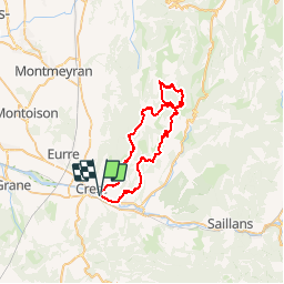
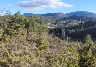
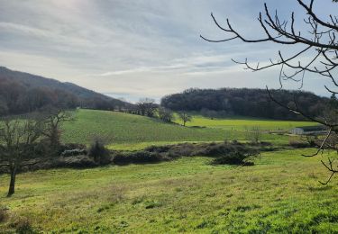
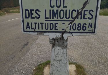
Superbe randonnée à mon goût qui traverse le massif du Vercors coté sud. Très beaux panoramas en haut de la montagne de Lozeron. Circuit dans l'ensemble assez roulant. Départ à la sortie de Crest en direction d'Aouste sur Sye. Possibilité donc de se garer sur le parking d'Intermarché, le départ se faisant sur une route juste en face. La montée autour de la montagne de Lozeron est assez longue mais cependant peu technique et la pente est régulière sans être trop difficile. L'ascension finale vers la serre de l'aigle est assez technique (virages serrés, adhérence limitée). Quelques poussages très courts si vous mettez pied à terre juste pour retrouver un endroit idéal pour redémarrer. Attention dans la descente après la serre de l'aigle, elle est très technique (gros escaliers et racines) donc prévoyez éventuellement des portages. Portages courts à prévoir dans la montée finale. A éviter après de grosses pluies ce qui rendrait les montées extrêmement difficiles.
Ort
Kommentare
Touren in der Umgebung
![Tour Wandern Crest - Crest / Col de Bessot - Photo](https://media.geolcdn.com/t/375/260/ext.jpg?maxdim=2&url=https%3A%2F%2Fservices.sitytrail.com%2FGeolivesWS%2FDownloadMedia.ashx%3FTrailID%3D497687%26Media%3Dfix__20151127133911.jpg)
![Wandern Wandern](https://static1.geolcdn.com/sitytour/trail-icons/101.png)
Wandern
![](/images/other/stat-length.png)
![](https://static1.geolcdn.com/siteimages/upload/files/16400158638029165_repeat_loop_refresh_sync_direction_icon.png)
![Wandern Wandern](https://static1.geolcdn.com/sitytour/trail-icons/101.png)
Wandern
![](/images/other/stat-length.png)
![](https://static1.geolcdn.com/siteimages/upload/files/16400158638029165_repeat_loop_refresh_sync_direction_icon.png)
![Tour Wandern Piégros-la-Clastre - cht de Piegros, chap de Médard - Photo](https://media.geolcdn.com/t/375/260/9cd8a646-1714-40d6-bd7d-290d8ba4a2e6.jpg&format=jpg&maxdim=2)
![Wandern Wandern](https://static1.geolcdn.com/sitytour/trail-icons/101.png)
Wandern
![](/images/other/stat-length.png)
![](https://static1.geolcdn.com/siteimages/upload/files/16400158638029165_repeat_loop_refresh_sync_direction_icon.png)
![Tour Mountainbike Aouste-sur-Sye - vtt vcs 120922 - Photo](https://media.geolcdn.com/t/375/260/ext.jpg?maxdim=2&url=https%3A%2F%2Fstatic1.geolcdn.com%2Fsiteimages%2Fupload%2Ffiles%2F1524743154velo.jpg)
![Mountainbike Mountainbike](https://static1.geolcdn.com/sitytour/trail-icons/202.png)
Mountainbike
![](/images/other/stat-length.png)
![](https://static1.geolcdn.com/siteimages/upload/files/16400158638029165_repeat_loop_refresh_sync_direction_icon.png)
![Tour Wandern Mirabel-et-Blacons - Le vieux Mirabel - Photo](https://media.geolcdn.com/t/375/260/6283c72e-165b-49ca-8460-8f24dc97a5b9.jpg&format=jpg&maxdim=2)
![Wandern Wandern](https://static1.geolcdn.com/sitytour/trail-icons/101.png)
Wandern
![](/images/other/stat-length.png)
![](https://static1.geolcdn.com/siteimages/upload/files/16400158638029165_repeat_loop_refresh_sync_direction_icon.png)
![Tour Wandern Aouste-sur-Sye - crête de Saint Alban. Aoust - Photo](https://media.geolcdn.com/t/375/260/638b2452-7773-4948-a643-cae10f47f13f.jpg&format=jpg&maxdim=2)
![Wandern Wandern](https://static1.geolcdn.com/sitytour/trail-icons/101.png)
Wandern
![](/images/other/stat-length.png)
![](https://static1.geolcdn.com/siteimages/upload/files/16400158638029165_repeat_loop_refresh_sync_direction_icon.png)
![Tour Wandern Crest - Crest à VAUNAVEY - Photo](https://media.geolcdn.com/t/375/260/286137c0-d121-4814-8720-e6aa22e27ac9.jpg&format=jpg&maxdim=2)
![Wandern Wandern](https://static1.geolcdn.com/sitytour/trail-icons/101.png)
Wandern
![](/images/other/stat-length.png)
![](https://static1.geolcdn.com/siteimages/upload/files/16400158638029165_repeat_loop_refresh_sync_direction_icon.png)
![Tour Rennrad Crest - j3 Crest limouche vauna vaunaveys 01.07.23 - Photo](https://media.geolcdn.com/t/375/260/f1e7664d-d94c-4a24-8662-9bd9acc5deea.jpg&format=jpg&maxdim=2)
![Rennrad Rennrad](https://static1.geolcdn.com/sitytour/trail-icons/201.png)
Rennrad
![](/images/other/stat-length.png)
![](https://static1.geolcdn.com/siteimages/upload/files/16400158638029165_repeat_loop_refresh_sync_direction_icon.png)
![Tour Wandern Crest - Crest les crêtes - Photo](https://media.geolcdn.com/t/375/260/d13859cb-c499-4b0f-86ce-a9a52bdb88e9.jpg&format=jpg&maxdim=2)
![Wandern Wandern](https://static1.geolcdn.com/sitytour/trail-icons/101.png)
Wandern
![](/images/other/stat-length.png)
![](https://static1.geolcdn.com/siteimages/upload/files/16400158638029165_repeat_loop_refresh_sync_direction_icon.png)