![](/images/other/stat-length.png)
![Tour Wandern Vollore-Ville - Le Grun de Chignore court - Photo](https://media.geolcdn.com/t/1900/400/ext.pjpeg?maxdim=2&url=https%3A%2F%2Fstatic1.geolcdn.com%2Fsiteimages%2Fupload%2Ffiles%2F1553511878bg_sport_marche.png)
Le Grun de Chignore court
tracegps
Benutzer
![Länge](/images/other/stat-length.png)
![Maximale Höhe](https://static1.geolcdn.com/siteimages/upload/files/1508320355ic_sort_altitude_max_24dp.png)
![Positive Höhendifferenz](https://static1.geolcdn.com/siteimages/upload/files/1508320355ic_sort_den_pos_24dp.png)
![Km-Effort](/images/other/stat-length.png)
![Min. Höhe](https://static1.geolcdn.com/siteimages/upload/files/1508320355ic_sort_altitude_min_24dp.png)
![Negative Höhendifferenz](https://static1.geolcdn.com/siteimages/upload/files/1508320355ic_sort_den_neg_24dp.png)
![Boucle](https://static1.geolcdn.com/siteimages/upload/files/16400158638029165_repeat_loop_refresh_sync_direction_icon.png)
![Wandern](https://static1.geolcdn.com/sitytour/trail-icons/101.png)
3h00
Schwierigkeit : Schwierig
![Scannen Sie diesen QR-Code, um die Tour in der SityTrail-Anwendung zu öffnen](https://capi.geolives.com/qq0zvz2zws4bq2lad0pu/sitytour/trails/103428/qr.png?size=200)
Kostenlosegpshiking-Anwendung
Über SityTrail
Tour Wandern von 11,4 km verfügbar auf Auvergne-Rhone-Alpen, Puy-de-Dôme, Vollore-Ville. Diese Tour wird von tracegps vorgeschlagen.
Beschreibung
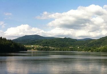
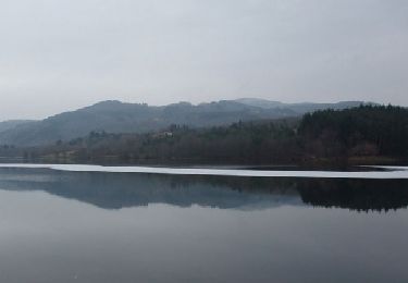
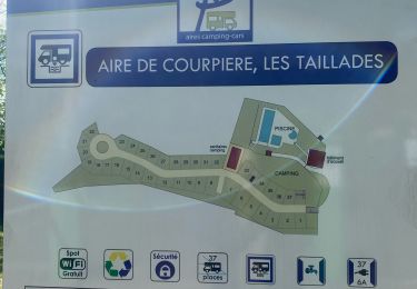
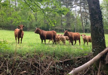
Rando dans les Monts du Forez sur les flancs du Grun de Chignore. Le départ se situe devant le camping de Vollore-ville. La montée emprunte de bons chemins à travers prés et forêts. Les chemins sont pavés par endroit, deviennent sentiers, sautent un ruisseau ou traversent un éboulis. En prenant de l'altitude, la forêt se densifie et l'on peut voir à l'horizon, à travers les trouées, la chaine des Puys à quelques 100 km de là. On entre dans la forêt d'Ayguebonne avant d'entamer la descente. Celle-ci est assez difficile car très caillouteuse et rapide (on passe de 900m à 520m en 2km). C'est une belle rando dans une nature restée sauvage, où l'on a pu apercevoir quelques animaux (écureuil, sanglier, chevreuil)en fin de journée.
Ort
Kommentare
Touren in der Umgebung
![Tour Wandern Aubusson-d'Auvergne - Aubusson_Lac - Photo](https://media.geolcdn.com/t/375/260/e8789334-900b-4b7b-aeae-be52f5c8b304.jpg&format=jpg&maxdim=2)
![Wandern Wandern](https://static1.geolcdn.com/sitytour/trail-icons/101.png)
Wandern
![](/images/other/stat-length.png)
![](https://static1.geolcdn.com/siteimages/upload/files/16400158638029165_repeat_loop_refresh_sync_direction_icon.png)
![Tour Wandern Courpière - Les Taillades près Courpière - Photo](https://media.geolcdn.com/t/375/260/ext.jpg?maxdim=2&url=https%3A%2F%2Fservices.sitytrail.com%2FGeolivesWS%2FDownloadMedia.ashx%3FTrailID%3D105959%26Media%3D10032_1.jpg)
![Wandern Wandern](https://static1.geolcdn.com/sitytour/trail-icons/101.png)
Wandern
![](/images/other/stat-length.png)
![](https://static1.geolcdn.com/siteimages/upload/files/16400158638029165_repeat_loop_refresh_sync_direction_icon.png)
![Tour Zu Fuß Vollore-Ville - Le Grun de Chignore - Photo](https://media.geolcdn.com/t/375/260/d670d619-94c1-4ebf-b98b-e05e4075dc52.jpeg&format=jpg&maxdim=2)
![Zu Fuß Zu Fuß](https://static1.geolcdn.com/sitytour/trail-icons/100.png)
Zu Fuß
![](/images/other/stat-length.png)
![](https://static1.geolcdn.com/siteimages/upload/files/16400158638029165_repeat_loop_refresh_sync_direction_icon.png)
![Tour Wandern Sainte-Agathe - Ste_Agathe_Peage - Photo](https://media.geolcdn.com/t/375/260/ae73d591-dc6d-481d-b0b0-e0d1ded3bb7c.jpg&format=jpg&maxdim=2)
![Wandern Wandern](https://static1.geolcdn.com/sitytour/trail-icons/101.png)
Wandern
![](/images/other/stat-length.png)
![](https://static1.geolcdn.com/siteimages/upload/files/16400158638029165_repeat_loop_refresh_sync_direction_icon.png)
![Tour Wandern Aubusson-d'Auvergne - Courpiere_Salet - Photo](https://media.geolcdn.com/t/375/260/bbf55bae-e8c1-4a54-bc8e-1404647a3e82.jpg&format=jpg&maxdim=2)
![Wandern Wandern](https://static1.geolcdn.com/sitytour/trail-icons/101.png)
Wandern
![](/images/other/stat-length.png)
![](https://static1.geolcdn.com/siteimages/upload/files/16400158638029165_repeat_loop_refresh_sync_direction_icon.png)
![Tour sport Courpière - COURPIERE Auvergne - Photo](https://media.geolcdn.com/t/375/260/998a6c45-edc4-4a49-93a0-d1f6173e4780.jpg&format=jpg&maxdim=2)
sport
![](/images/other/stat-length.png)
![](https://static1.geolcdn.com/siteimages/upload/files/16400158638029165_repeat_loop_refresh_sync_direction_icon.png)
![Tour Wandern Sainte-Agathe - Saint agate 3ieme jour - Photo](https://media.geolcdn.com/t/375/260/339ddc93-a3ab-4bd3-b422-9ab8f5ca89f2.jpg&format=jpg&maxdim=2)
![Wandern Wandern](https://static1.geolcdn.com/sitytour/trail-icons/101.png)
Wandern
![](/images/other/stat-length.png)
![](https://static1.geolcdn.com/siteimages/upload/files/16400158638029165_repeat_loop_refresh_sync_direction_icon.png)
![Tour Wandern Aubusson-d'Auvergne - Les quatre vents Aubusson 1er jour - Photo](https://media.geolcdn.com/t/375/260/76dd7eb9-eaaa-4c14-b581-8d417a1c9807.jpg&format=jpg&maxdim=2)
![Wandern Wandern](https://static1.geolcdn.com/sitytour/trail-icons/101.png)
Wandern
![](/images/other/stat-length.png)
![](https://static1.geolcdn.com/siteimages/upload/files/16400158638029165_repeat_loop_refresh_sync_direction_icon.png)
![Tour Zu Fuß Sainte-Agathe - Le Peage - Photo](https://media.geolcdn.com/t/375/260/ext.jpg?maxdim=2&url=https%3A%2F%2Fstatic1.geolcdn.com%2Fsiteimages%2Fupload%2Ffiles%2F1545311037marcheuse_200dpi.jpg)
![Zu Fuß Zu Fuß](https://static1.geolcdn.com/sitytour/trail-icons/100.png)
Zu Fuß
![](/images/other/stat-length.png)
![](https://static1.geolcdn.com/siteimages/upload/files/16400158638029165_repeat_loop_refresh_sync_direction_icon.png)