![](/images/other/stat-length.png)
![Tour Mountainbike Fosseux - Lucheux - Photo](https://media.geolcdn.com/t/1900/400/ext.pjpeg?maxdim=2&url=https%3A%2F%2Fstatic1.geolcdn.com%2Fsiteimages%2Fupload%2Ffiles%2F1524743154velo.jpg)
Lucheux
tracegps
Benutzer
![Länge](/images/other/stat-length.png)
Länge
44 km
![Maximale Höhe](https://static1.geolcdn.com/siteimages/upload/files/1508320355ic_sort_altitude_max_24dp.png)
Maximale Höhe
174 m
![Positive Höhendifferenz](https://static1.geolcdn.com/siteimages/upload/files/1508320355ic_sort_den_pos_24dp.png)
Positive Höhendifferenz
448 m
![Km-Effort](/images/other/stat-length.png)
Km-Effort
50 km
![Min. Höhe](https://static1.geolcdn.com/siteimages/upload/files/1508320355ic_sort_altitude_min_24dp.png)
Min. Höhe
78 m
![Negative Höhendifferenz](https://static1.geolcdn.com/siteimages/upload/files/1508320355ic_sort_den_neg_24dp.png)
Negative Höhendifferenz
450 m
![Boucle](https://static1.geolcdn.com/siteimages/upload/files/16400158638029165_repeat_loop_refresh_sync_direction_icon.png)
Boucle
Ja
Erstellungsdatum :
2014-12-10 00:00:00.0
Letzte Änderung :
2014-12-10 00:00:00.0
![Mountainbike](https://static1.geolcdn.com/sitytour/trail-icons/202.png)
3h00
Schwierigkeit : Medium
![Scannen Sie diesen QR-Code, um die Tour in der SityTrail-Anwendung zu öffnen](https://capi.geolives.com/qq0zvz2zws4bq2lad0pu/sitytour/trails/103422/qr.png?size=200)
Kostenlosegpshiking-Anwendung
Über SityTrail
Tour Mountainbike von 44 km verfügbar auf Nordfrankreich, Pas-de-Calais, Fosseux. Diese Tour wird von tracegps vorgeschlagen.
Beschreibung
Départ du circuit près de Avesnes le Comte, Circuit très roulant jusqu'à Lucheux où à partir de là tout ce complique! Circuit de 44 km avec bitume et sous bois à faire absolument
Ort
Land:
France
Region :
Nordfrankreich
Abteilung/Provinz :
Pas-de-Calais
Kommune :
Fosseux
Standort:
Unknown
Gehen Sie:(Dec)
Gehen Sie:(UTM)
468780 ; 5567265 (31U) N.
Kommentare
Touren in der Umgebung
![Tour Mountainbike Avesnes-le-Comte - Les 6 châteaux - Avesnes le Comte - Photo](https://media.geolcdn.com/t/375/260/ext.jpg?maxdim=2&url=https%3A%2F%2Fstatic1.geolcdn.com%2Fsiteimages%2Fupload%2Ffiles%2F1524743154velo.jpg)
![Mountainbike Mountainbike](https://static1.geolcdn.com/sitytour/trail-icons/202.png)
Les 6 châteaux - Avesnes le Comte
Mountainbike
Schwierig
(1)
Avesnes-le-Comte,
Nordfrankreich,
Pas-de-Calais,
France
![](/images/other/stat-length.png)
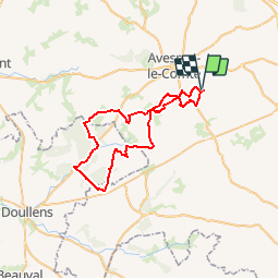
44 km | 50 km-effort
2h 10min
![](https://static1.geolcdn.com/siteimages/upload/files/16400158638029165_repeat_loop_refresh_sync_direction_icon.png)
Ja
![Tour Wandern Avesnes-le-Comte - Avesnes le Comte, Noyelle-Vion, Manin, Beaufort-Blavincourt - Photo](https://media.geolcdn.com/t/375/260/ext.jpg?maxdim=2&url=https%3A%2F%2Fservices.sitytrail.com%2FGeolivesWS%2FDownloadMedia.ashx%3FTrailID%3D191466%26Media%3D15058_1.jpg)
![Wandern Wandern](https://static1.geolcdn.com/sitytour/trail-icons/101.png)
Avesnes le Comte, Noyelle-Vion, Manin, Beaufort-Blavincourt
Wandern
Medium
Avesnes-le-Comte,
Nordfrankreich,
Pas-de-Calais,
France
![](/images/other/stat-length.png)
10,8 km | 12,2 km-effort
2h 30min
![](https://static1.geolcdn.com/siteimages/upload/files/16400158638029165_repeat_loop_refresh_sync_direction_icon.png)
Ja
![Tour Wandern Hauteville - Randonnée autour de Hauteville - Barly - Fosseux - Photo](https://media.geolcdn.com/t/375/260/ext.jpg?maxdim=2&url=https%3A%2F%2Fservices.sitytrail.com%2FGeolivesWS%2FDownloadMedia.ashx%3FTrailID%3D106984%26Media%3D11756_1.jpg)
![Wandern Wandern](https://static1.geolcdn.com/sitytour/trail-icons/101.png)
Randonnée autour de Hauteville - Barly - Fosseux
Wandern
Medium
Hauteville,
Nordfrankreich,
Pas-de-Calais,
France
![](/images/other/stat-length.png)
10,4 km | 11,8 km-effort
2h 0min
![](https://static1.geolcdn.com/siteimages/upload/files/16400158638029165_repeat_loop_refresh_sync_direction_icon.png)
Ja
![Tour Wandern Montenescourt - Montenescourt - Gouves - Wanquetin - Photo](https://media.geolcdn.com/t/375/260/ext.jpg?maxdim=2&url=https%3A%2F%2Fservices.sitytrail.com%2FGeolivesWS%2FDownloadMedia.ashx%3FTrailID%3D105946%26Media%3D9997_1.jpg)
![Wandern Wandern](https://static1.geolcdn.com/sitytour/trail-icons/101.png)
Montenescourt - Gouves - Wanquetin
Wandern
Medium
Montenescourt,
Nordfrankreich,
Pas-de-Calais,
France
![](/images/other/stat-length.png)
10,6 km | 11,9 km-effort
2h 0min
![](https://static1.geolcdn.com/siteimages/upload/files/16400158638029165_repeat_loop_refresh_sync_direction_icon.png)
Ja
![Tour Wandern Bavincourt - Le sentier de la longue Borne - Bavincourt - Photo](https://media.geolcdn.com/t/375/260/ext.jpg?maxdim=2&url=https%3A%2F%2Fservices.sitytrail.com%2FGeolivesWS%2FDownloadMedia.ashx%3FTrailID%3D104255%26Media%3D7450_1.jpg)
![Wandern Wandern](https://static1.geolcdn.com/sitytour/trail-icons/101.png)
Le sentier de la longue Borne - Bavincourt
Wandern
Medium
Bavincourt,
Nordfrankreich,
Pas-de-Calais,
France
![](/images/other/stat-length.png)
9,8 km | 10,9 km-effort
2h 30min
![](https://static1.geolcdn.com/siteimages/upload/files/16400158638029165_repeat_loop_refresh_sync_direction_icon.png)
Ja
![Tour Wandern Gouy-en-Artois - Le sentier des loups - Gouy en Artois - Photo](https://media.geolcdn.com/t/375/260/ext.jpg?maxdim=2&url=https%3A%2F%2Fservices.sitytrail.com%2FGeolivesWS%2FDownloadMedia.ashx%3FTrailID%3D104254%26Media%3D7449_2.jpg)
![Wandern Wandern](https://static1.geolcdn.com/sitytour/trail-icons/101.png)
Le sentier des loups - Gouy en Artois
Wandern
Schwierig
Gouy-en-Artois,
Nordfrankreich,
Pas-de-Calais,
France
![](/images/other/stat-length.png)
14,2 km | 15,9 km-effort
3h 34min
![](https://static1.geolcdn.com/siteimages/upload/files/16400158638029165_repeat_loop_refresh_sync_direction_icon.png)
Ja
![Tour Wandern Montenescourt - Montenescourt Habarcq Hermaville Bois d'Habarcq - Photo](https://media.geolcdn.com/t/375/260/ext.jpg?maxdim=2&url=https%3A%2F%2Fservices.sitytrail.com%2FGeolivesWS%2FDownloadMedia.ashx%3FTrailID%3D104208%26Media%3D7359_1.jpg)
![Wandern Wandern](https://static1.geolcdn.com/sitytour/trail-icons/101.png)
Montenescourt Habarcq Hermaville Bois d'Habarcq
Wandern
Medium
Montenescourt,
Nordfrankreich,
Pas-de-Calais,
France
![](/images/other/stat-length.png)
11 km | 12,9 km-effort
2h 0min
![](https://static1.geolcdn.com/siteimages/upload/files/16400158638029165_repeat_loop_refresh_sync_direction_icon.png)
Ja
![Tour Wandern Givenchy-le-Noble - Givenchy le Noble - Ambrines - Denier - Lignereuil - Photo](https://media.geolcdn.com/t/375/260/ext.jpg?maxdim=2&url=https%3A%2F%2Fservices.sitytrail.com%2FGeolivesWS%2FDownloadMedia.ashx%3FTrailID%3D104002%26Media%3D6942_2.jpg)
![Wandern Wandern](https://static1.geolcdn.com/sitytour/trail-icons/101.png)
Givenchy le Noble - Ambrines - Denier - Lignereuil
Wandern
Medium
Givenchy-le-Noble,
Nordfrankreich,
Pas-de-Calais,
France
![](/images/other/stat-length.png)
11 km | 12,5 km-effort
2h 0min
![](https://static1.geolcdn.com/siteimages/upload/files/16400158638029165_repeat_loop_refresh_sync_direction_icon.png)
Ja
![Tour Wandern Montenescourt - Montenescourt - Wanquetin - Noyellette - Habarcq - Gouves - Photo](https://media.geolcdn.com/t/375/260/ext.jpg?maxdim=2&url=https%3A%2F%2Fstatic1.geolcdn.com%2Fsiteimages%2Fupload%2Ffiles%2F1553511878bg_sport_marche.png)
![Wandern Wandern](https://static1.geolcdn.com/sitytour/trail-icons/101.png)
Montenescourt - Wanquetin - Noyellette - Habarcq - Gouves
Wandern
Medium
Montenescourt,
Nordfrankreich,
Pas-de-Calais,
France
![](/images/other/stat-length.png)
10,1 km | 11,2 km-effort
2h 0min
![](https://static1.geolcdn.com/siteimages/upload/files/16400158638029165_repeat_loop_refresh_sync_direction_icon.png)
Ja
super a faire