![](/images/other/stat-length.png)
![Tour Wandern Villeneuve-sur-Yonne - Les coteaux de l'Yonne - Photo](https://media.geolcdn.com/t/1900/400/ext.pjpeg?maxdim=2&url=https%3A%2F%2Fservices.sitytrail.com%2FGeolivesWS%2FDownloadMedia.ashx%3FTrailID%3D103416%26Media%3D5526_6.jpg)
Les coteaux de l'Yonne
tracegps
Benutzer
![Länge](/images/other/stat-length.png)
Länge
16,2 km
![Maximale Höhe](https://static1.geolcdn.com/siteimages/upload/files/1508320355ic_sort_altitude_max_24dp.png)
Maximale Höhe
188 m
![Positive Höhendifferenz](https://static1.geolcdn.com/siteimages/upload/files/1508320355ic_sort_den_pos_24dp.png)
Positive Höhendifferenz
315 m
![Km-Effort](/images/other/stat-length.png)
Km-Effort
20 km
![Min. Höhe](https://static1.geolcdn.com/siteimages/upload/files/1508320355ic_sort_altitude_min_24dp.png)
Min. Höhe
75 m
![Negative Höhendifferenz](https://static1.geolcdn.com/siteimages/upload/files/1508320355ic_sort_den_neg_24dp.png)
Negative Höhendifferenz
317 m
![Boucle](https://static1.geolcdn.com/siteimages/upload/files/16400158638029165_repeat_loop_refresh_sync_direction_icon.png)
Boucle
Ja
Erstellungsdatum :
2014-12-10 00:00:00.0
Letzte Änderung :
2014-12-10 00:00:00.0
![Wandern](https://static1.geolcdn.com/sitytour/trail-icons/101.png)
5h00
Schwierigkeit : Medium
![Scannen Sie diesen QR-Code, um die Tour in der SityTrail-Anwendung zu öffnen](https://capi.geolives.com/qq0zvz2zws4bq2lad0pu/sitytour/trails/103416/qr.png?size=200)
Kostenlosegpshiking-Anwendung
Über SityTrail
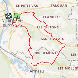
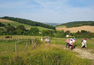
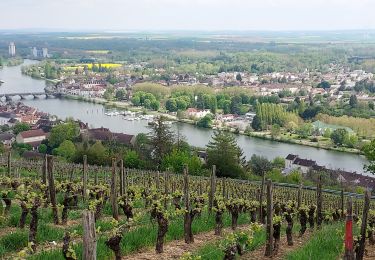
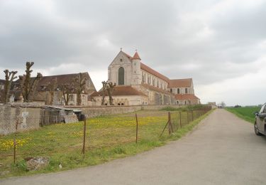
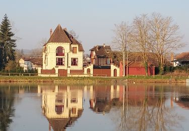
Tour Wandern von 16,2 km verfügbar auf Burgund und Freigrafschaft, Yonne, Villeneuve-sur-Yonne. Diese Tour wird von tracegps vorgeschlagen.
Beschreibung
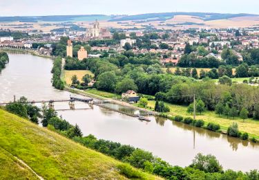
Départ et visite de Villeneuve-sur-Yonne, puis montée sur les coteaux de l'Yonne en direction d'Armeau, une visite vers l'Yonne et le retour.
Ort
Land:
France
Region :
Burgund und Freigrafschaft
Abteilung/Provinz :
Yonne
Kommune :
Villeneuve-sur-Yonne
Standort:
Unknown
Gehen Sie:(Dec)
Gehen Sie:(UTM)
521984 ; 5325434 (31U) N.
Kommentare
Touren in der Umgebung
![Tour Wandern Armeau - Armeau - Photo](https://media.geolcdn.com/t/375/260/ext.jpg?maxdim=2&url=https%3A%2F%2Fservices.sitytrail.com%2FGeolivesWS%2FDownloadMedia.ashx%3FTrailID%3D226655%26Media%3Dfix__20131012120940.jpg)
![Wandern Wandern](https://static1.geolcdn.com/sitytour/trail-icons/101.png)
Armeau
Wandern
Sehr leicht
(2)
Armeau,
Burgund und Freigrafschaft,
Yonne,
France
![](/images/other/stat-length.png)
11,1 km | 13,4 km-effort
2h 55min
![](https://static1.geolcdn.com/siteimages/upload/files/16400158638029165_repeat_loop_refresh_sync_direction_icon.png)
Ja
![Tour Zu Fuß Villeneuve-sur-Yonne - Villeneuve Sur Yonne - Sens 32 km étape 1/3 - Photo](https://media.geolcdn.com/t/375/260/3d0368b3-5e3a-439d-b5c0-228edc49e6c9.jpg&format=jpg&maxdim=2)
![Zu Fuß Zu Fuß](https://static1.geolcdn.com/sitytour/trail-icons/100.png)
Villeneuve Sur Yonne - Sens 32 km étape 1/3
Zu Fuß
Schwierig
Villeneuve-sur-Yonne,
Burgund und Freigrafschaft,
Yonne,
France
![](/images/other/stat-length.png)
32 km | 40 km-effort
9h 0min
![](https://static1.geolcdn.com/siteimages/upload/files/16400158638029165_repeat_loop_refresh_sync_direction_icon.png)
Nein
![Tour Fahrrad Armeau - RTT 2023 Armeau - G1P1 - 51km - D+363-12149687 - Photo](https://media.geolcdn.com/t/375/260/ext.jpg?maxdim=2&url=https%3A%2F%2Fstatic1.geolcdn.com%2Fsiteimages%2Fupload%2Ffiles%2F1524743154velo.jpg)
![Fahrrad Fahrrad](https://static1.geolcdn.com/sitytour/trail-icons/200.png)
RTT 2023 Armeau - G1P1 - 51km - D+363-12149687
Fahrrad
Sehr leicht
(1)
Armeau,
Burgund und Freigrafschaft,
Yonne,
France
![](/images/other/stat-length.png)
51 km | 57 km-effort
Unbekannt
![](https://static1.geolcdn.com/siteimages/upload/files/16400158638029165_repeat_loop_refresh_sync_direction_icon.png)
Ja
![Tour Wandern Villeneuve-sur-Yonne - 220717 Villeneuve sur Yonne 10,8 km - Photo](https://media.geolcdn.com/t/375/260/6a9030e7-71f5-4158-a530-e6fbaad03b97.jpg&format=jpg&maxdim=2)
![Wandern Wandern](https://static1.geolcdn.com/sitytour/trail-icons/101.png)
220717 Villeneuve sur Yonne 10,8 km
Wandern
Einfach
(1)
Villeneuve-sur-Yonne,
Burgund und Freigrafschaft,
Yonne,
France
![](/images/other/stat-length.png)
11,1 km | 14,1 km-effort
4h 2min
![](https://static1.geolcdn.com/siteimages/upload/files/16400158638029165_repeat_loop_refresh_sync_direction_icon.png)
Ja
![Tour Mountainbike Villeneuve-sur-Yonne - 2020-10-23_20h47m43_Randonnée Villeneuve à Villecien - Photo](https://media.geolcdn.com/t/375/260/ext.jpg?maxdim=2&url=https%3A%2F%2Fstatic1.geolcdn.com%2Fsiteimages%2Fupload%2Ffiles%2F1524743154velo.jpg)
![Mountainbike Mountainbike](https://static1.geolcdn.com/sitytour/trail-icons/202.png)
2020-10-23_20h47m43_Randonnée Villeneuve à Villecien
Mountainbike
Schwierig
(1)
Villeneuve-sur-Yonne,
Burgund und Freigrafschaft,
Yonne,
France
![](/images/other/stat-length.png)
35 km | 37 km-effort
2h 33min
![](https://static1.geolcdn.com/siteimages/upload/files/16400158638029165_repeat_loop_refresh_sync_direction_icon.png)
Ja
![Tour Wandern Véron - La Grange aux Doyens 240720 - Photo](https://media.geolcdn.com/t/375/260/62b21894-d924-4c72-93ce-66a374227d72.jpg&format=jpg&maxdim=2)
![Wandern Wandern](https://static1.geolcdn.com/sitytour/trail-icons/101.png)
La Grange aux Doyens 240720
Wandern
Medium
Véron,
Burgund und Freigrafschaft,
Yonne,
France
![](/images/other/stat-length.png)
11,1 km | 14,3 km-effort
3h 44min
![](https://static1.geolcdn.com/siteimages/upload/files/16400158638029165_repeat_loop_refresh_sync_direction_icon.png)
Ja
![Tour Rennrad Armeau - RAL 72-2 Armeau (RTT) - Photo](https://media.geolcdn.com/t/375/260/e6114834-ad46-4561-bbae-064d7251788b.jpg&format=jpg&maxdim=2)
![Rennrad Rennrad](https://static1.geolcdn.com/sitytour/trail-icons/201.png)
RAL 72-2 Armeau (RTT)
Rennrad
Einfach
Armeau,
Burgund und Freigrafschaft,
Yonne,
France
![](/images/other/stat-length.png)
43 km | 49 km-effort
2h 53min
![](https://static1.geolcdn.com/siteimages/upload/files/16400158638029165_repeat_loop_refresh_sync_direction_icon.png)
Ja
![Radtourismus Radtourismus](https://static1.geolcdn.com/sitytour/trail-icons/204.png)
SEJOUR EN BOURGOGNE
Radtourismus
Sehr schwierig
Villeneuve-sur-Yonne,
Burgund und Freigrafschaft,
Yonne,
France
![](/images/other/stat-length.png)
127 km | 148 km-effort
Unbekannt
![](https://static1.geolcdn.com/siteimages/upload/files/16400158638029165_repeat_loop_refresh_sync_direction_icon.png)
Nein
![Tour Wandern Villeneuve-sur-Yonne - 220306 Villeneuve sur Yonne - Photo](https://media.geolcdn.com/t/375/260/83b9078f-1bf7-498d-b388-8e4ce7b17c81.jpg&format=jpg&maxdim=2)
![Wandern Wandern](https://static1.geolcdn.com/sitytour/trail-icons/101.png)
220306 Villeneuve sur Yonne
Wandern
Sehr leicht
Villeneuve-sur-Yonne,
Burgund und Freigrafschaft,
Yonne,
France
![](/images/other/stat-length.png)
10,3 km | 11,5 km-effort
3h 20min
![](https://static1.geolcdn.com/siteimages/upload/files/16400158638029165_repeat_loop_refresh_sync_direction_icon.png)
Ja