![](/images/other/stat-length.png)
![Tour Wandern Montazels - Sur les traces de l'abbé Saunière - Photo](https://media.geolcdn.com/t/1900/400/ext.pjpeg?maxdim=2&url=https%3A%2F%2Fservices.sitytrail.com%2FGeolivesWS%2FDownloadMedia.ashx%3FTrailID%3D103365%26Media%3D5420_3.jpg)
Sur les traces de l'abbé Saunière
tracegps
Benutzer
![Länge](/images/other/stat-length.png)
![Maximale Höhe](https://static1.geolcdn.com/siteimages/upload/files/1508320355ic_sort_altitude_max_24dp.png)
![Positive Höhendifferenz](https://static1.geolcdn.com/siteimages/upload/files/1508320355ic_sort_den_pos_24dp.png)
![Km-Effort](/images/other/stat-length.png)
![Min. Höhe](https://static1.geolcdn.com/siteimages/upload/files/1508320355ic_sort_altitude_min_24dp.png)
![Negative Höhendifferenz](https://static1.geolcdn.com/siteimages/upload/files/1508320355ic_sort_den_neg_24dp.png)
![Boucle](https://static1.geolcdn.com/siteimages/upload/files/16400158638029165_repeat_loop_refresh_sync_direction_icon.png)
![Wandern](https://static1.geolcdn.com/sitytour/trail-icons/101.png)
5h30
Schwierigkeit : Medium
![Scannen Sie diesen QR-Code, um die Tour in der SityTrail-Anwendung zu öffnen](https://capi.geolives.com/qq0zvz2zws4bq2lad0pu/sitytour/trails/103365/qr.png?size=200)
Kostenlosegpshiking-Anwendung
Über SityTrail
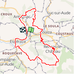
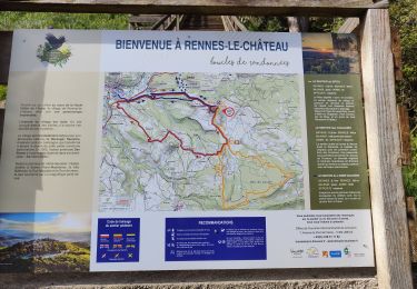
Tour Wandern von 22 km verfügbar auf Okzitanien, Aude, Montazels. Diese Tour wird von tracegps vorgeschlagen.
Beschreibung
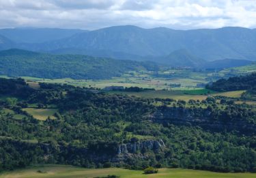
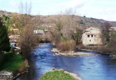
Belle rando au départ de la gare d'Espéraza. Monter au village d'Antugnac par les vignes et ensuite Mont Sec avec sa vue sur le parc éoliens de Roquetaillade et son 360 ° sur la chaine des Pyrénées et la Haute Vallée de l'Aude. Vue superbe sur le pic de Bugarach. Descente vers Montazels (point d'eau à l'église), ancienne cité chapelière et village natal de l'abbé. On traverse l'Aude et nous montons sur Rennes le Château par un superbe sentier. Arrivée au village par l'escalier de la source et passer visiter son église et l'histoire de son curé.(point d'eau). Superbe point de vue et on repart par le sentier "des ritous" (curé en occitan) vers le ruisseau et retour par Pailheres et le plateau de Savounet . Si vous avez le temps, visiter les musées dinosaure et chapellerie (gratuit).
Ort
Kommentare
Touren in der Umgebung
![Tour Wandern Espéraza - Espéraza Alain Crous Antugnac Couiza - Photo](https://media.geolcdn.com/t/375/260/ext.jpg?maxdim=2&url=https%3A%2F%2Fstatic1.geolcdn.com%2Fsiteimages%2Fupload%2Ffiles%2F1553511878bg_sport_marche.png)
![Wandern Wandern](https://static1.geolcdn.com/sitytour/trail-icons/101.png)
Wandern
![](/images/other/stat-length.png)
![](https://static1.geolcdn.com/siteimages/upload/files/16400158638029165_repeat_loop_refresh_sync_direction_icon.png)
![Tour Wandern Espéraza - Esperaza Rennes le château - Photo](https://media.geolcdn.com/t/375/260/25f32597-0cc0-4b94-8089-2796ff90a7d2.jpg&format=jpg&maxdim=2)
![Wandern Wandern](https://static1.geolcdn.com/sitytour/trail-icons/101.png)
Wandern
![](/images/other/stat-length.png)
![](https://static1.geolcdn.com/siteimages/upload/files/16400158638029165_repeat_loop_refresh_sync_direction_icon.png)
![Tour Wandern Antugnac - Montazels - Photo](https://media.geolcdn.com/t/375/260/e053b1cc-cb5b-4e80-8473-2af3823e4c5a.jpg&format=jpg&maxdim=2)
![Wandern Wandern](https://static1.geolcdn.com/sitytour/trail-icons/101.png)
![Tour Wandern Rennes-le-Château - Rennes le Château - Photo](https://media.geolcdn.com/t/375/260/1a7a8025-e376-4adf-91ac-565091fd51c9.jpg&format=jpg&maxdim=2)
![Wandern Wandern](https://static1.geolcdn.com/sitytour/trail-icons/101.png)
Wandern
![](/images/other/stat-length.png)
![](https://static1.geolcdn.com/siteimages/upload/files/16400158638029165_repeat_loop_refresh_sync_direction_icon.png)
![Wandern Wandern](https://static1.geolcdn.com/sitytour/trail-icons/101.png)
Wandern
![](/images/other/stat-length.png)
![](https://static1.geolcdn.com/siteimages/upload/files/16400158638029165_repeat_loop_refresh_sync_direction_icon.png)
![Tour Wandern Val-du-Faby - gogo1965 - Photo](https://media.geolcdn.com/t/375/260/14aad6f4-9e03-4e12-ba07-ab13db2a19ec.jpg&format=jpg&maxdim=2)
![Wandern Wandern](https://static1.geolcdn.com/sitytour/trail-icons/101.png)
![Tour Wandern Couiza - Couiza 12 kms - Photo](https://media.geolcdn.com/t/375/260/9be0bcab-52ce-463d-916b-0cd0cbbf5348.jpg&format=jpg&maxdim=2)
![Wandern Wandern](https://static1.geolcdn.com/sitytour/trail-icons/101.png)
Wandern
![](/images/other/stat-length.png)
![](https://static1.geolcdn.com/siteimages/upload/files/16400158638029165_repeat_loop_refresh_sync_direction_icon.png)
![Tour Mountainbike Espéraza - Espace VTT FFC Aude en Pyrénées - Circuit n° 08 - Espéraza / Fa / Rouvenac - Photo](https://media.geolcdn.com/t/375/260/ext.jpg?maxdim=2&url=https%3A%2F%2Fservices.sitytrail.com%2FGeolivesWS%2FDownloadMedia.ashx%3FTrailID%3D103958%26Media%3D6841_1.jpg)
![Mountainbike Mountainbike](https://static1.geolcdn.com/sitytour/trail-icons/202.png)
Mountainbike
![](/images/other/stat-length.png)
![](https://static1.geolcdn.com/siteimages/upload/files/16400158638029165_repeat_loop_refresh_sync_direction_icon.png)
![Tour Mountainbike Espéraza - Espace VTT FFC Aude en Pyrénées - Circuit n° 05 - Espéraza / Saint Ferriol / Granes - Photo](https://media.geolcdn.com/t/375/260/ext.jpg?maxdim=2&url=https%3A%2F%2Fservices.sitytrail.com%2FGeolivesWS%2FDownloadMedia.ashx%3FTrailID%3D103955%26Media%3D6838_1.jpg)
![Mountainbike Mountainbike](https://static1.geolcdn.com/sitytour/trail-icons/202.png)
Mountainbike
![](/images/other/stat-length.png)
![](https://static1.geolcdn.com/siteimages/upload/files/16400158638029165_repeat_loop_refresh_sync_direction_icon.png)