![](/images/other/stat-length.png)
![Tour Laufen Messanges - Messanges côté plage - Photo](https://media.geolcdn.com/t/1900/400/ext.pjpeg?maxdim=2&url=https%3A%2F%2Fstatic1.geolcdn.com%2Fsiteimages%2Fupload%2Ffiles%2F1524743154running.jpg)
Messanges côté plage
tracegps
Benutzer
![Länge](/images/other/stat-length.png)
Länge
9,7 km
![Maximale Höhe](https://static1.geolcdn.com/siteimages/upload/files/1508320355ic_sort_altitude_max_24dp.png)
Maximale Höhe
25 m
![Positive Höhendifferenz](https://static1.geolcdn.com/siteimages/upload/files/1508320355ic_sort_den_pos_24dp.png)
Positive Höhendifferenz
112 m
![Km-Effort](/images/other/stat-length.png)
Km-Effort
11,2 km
![Min. Höhe](https://static1.geolcdn.com/siteimages/upload/files/1508320355ic_sort_altitude_min_24dp.png)
Min. Höhe
2 m
![Negative Höhendifferenz](https://static1.geolcdn.com/siteimages/upload/files/1508320355ic_sort_den_neg_24dp.png)
Negative Höhendifferenz
114 m
![Boucle](https://static1.geolcdn.com/siteimages/upload/files/16400158638029165_repeat_loop_refresh_sync_direction_icon.png)
Boucle
Ja
Erstellungsdatum :
2014-12-10 00:00:00.0
Letzte Änderung :
2014-12-10 00:00:00.0
![Laufen](https://static1.geolcdn.com/sitytour/trail-icons/103.png)
1h00
Schwierigkeit : Medium
![Scannen Sie diesen QR-Code, um die Tour in der SityTrail-Anwendung zu öffnen](https://capi.geolives.com/qq0zvz2zws4bq2lad0pu/sitytour/trails/103301/qr.png?size=200)
Kostenlosegpshiking-Anwendung
Über SityTrail
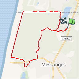
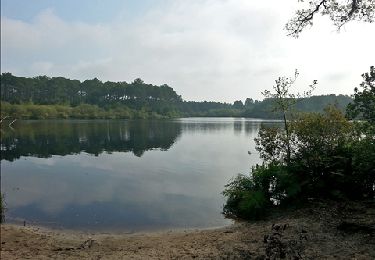
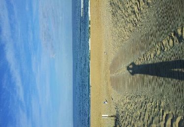
Tour Laufen von 9,7 km verfügbar auf Neu-Aquitanien, Landes, Messanges. Diese Tour wird von tracegps vorgeschlagen.
Beschreibung
Départ de la Ferme équestre de la Prade, à Messanges. Jolie balade en forêt où vous longerez pendant un petit moment la côte Atlantique (la plage est juste derrière la dune). Seule difficulté : du sable, du sable, du sable...
Ort
Land:
France
Region :
Neu-Aquitanien
Abteilung/Provinz :
Landes
Kommune :
Messanges
Standort:
Unknown
Gehen Sie:(Dec)
Gehen Sie:(UTM)
631023 ; 4854228 (30T) N.
Kommentare
Touren in der Umgebung
![Tour Wandern Léon - Etang VSP 10km - Photo](https://media.geolcdn.com/t/375/260/0f991cfe-6bda-4037-a335-2a4be6192310.jpg&format=jpg&maxdim=2)
![Wandern Wandern](https://static1.geolcdn.com/sitytour/trail-icons/101.png)
Etang VSP 10km
Wandern
Einfach
(1)
Léon,
Neu-Aquitanien,
Landes,
France
![](/images/other/stat-length.png)
10,2 km | 12,1 km-effort
2h 1min
![](https://static1.geolcdn.com/siteimages/upload/files/16400158638029165_repeat_loop_refresh_sync_direction_icon.png)
Ja
![Tour Mountainbike Vieux-Boucau-les-Bains - Soustons→étang hardy - Photo](https://media.geolcdn.com/t/375/260/ext.jpg?maxdim=2&url=https%3A%2F%2Fstatic1.geolcdn.com%2Fsiteimages%2Fupload%2Ffiles%2F1524743154velo.jpg)
![Mountainbike Mountainbike](https://static1.geolcdn.com/sitytour/trail-icons/202.png)
Soustons→étang hardy
Mountainbike
Medium
(2)
Vieux-Boucau-les-Bains,
Neu-Aquitanien,
Landes,
France
![](/images/other/stat-length.png)
42 km | 48 km-effort
3h 21min
![](https://static1.geolcdn.com/siteimages/upload/files/16400158638029165_repeat_loop_refresh_sync_direction_icon.png)
Ja
![Tour Wandern Léon - Courant du Huchet - Photo](https://media.geolcdn.com/t/375/260/32dab752-80e3-43c9-adcf-46932eefb47e.jpg&format=jpg&maxdim=2)
![Wandern Wandern](https://static1.geolcdn.com/sitytour/trail-icons/101.png)
Courant du Huchet
Wandern
Sehr leicht
Léon,
Neu-Aquitanien,
Landes,
France
![](/images/other/stat-length.png)
18,6 km | 21 km-effort
5h 30min
![](https://static1.geolcdn.com/siteimages/upload/files/16400158638029165_repeat_loop_refresh_sync_direction_icon.png)
Nein
![Tour Wandern Moliets-et-Maâ - circuit des Cigales camping au courant d'Uchet et retour - Photo](https://media.geolcdn.com/t/375/260/cb479472-290b-4db1-bc86-532d9c3e1638.jpg&format=jpg&maxdim=2)
![Wandern Wandern](https://static1.geolcdn.com/sitytour/trail-icons/101.png)
circuit des Cigales camping au courant d'Uchet et retour
Wandern
Einfach
Moliets-et-Maâ,
Neu-Aquitanien,
Landes,
France
![](/images/other/stat-length.png)
6,5 km | 7,2 km-effort
1h 46min
![](https://static1.geolcdn.com/siteimages/upload/files/16400158638029165_repeat_loop_refresh_sync_direction_icon.png)
Ja
![Tour Wandern Vieux-Boucau-les-Bains - vieux boucau golf - Photo](https://media.geolcdn.com/t/375/260/ext.jpg?maxdim=2&url=https%3A%2F%2Fstatic1.geolcdn.com%2Fsiteimages%2Fupload%2Ffiles%2F1553511878bg_sport_marche.png)
![Wandern Wandern](https://static1.geolcdn.com/sitytour/trail-icons/101.png)
vieux boucau golf
Wandern
Sehr leicht
(2)
Vieux-Boucau-les-Bains,
Neu-Aquitanien,
Landes,
France
![](/images/other/stat-length.png)
8 km | 8,7 km-effort
2h 12min
![](https://static1.geolcdn.com/siteimages/upload/files/16400158638029165_repeat_loop_refresh_sync_direction_icon.png)
Ja
![Tour Wandern Moliets-et-Maâ - Le Courant d' Huchet _ 5,3 km_Trace GPS - Photo](https://media.geolcdn.com/t/375/260/ext.jpg?maxdim=2&url=https%3A%2F%2Fservices.sitytrail.com%2FGeolivesWS%2FDownloadMedia.ashx%3FTrailID%3D221866%26Media%3D358f56fb-4383-43a9-84d6-d433489d3737.jpg)
![Wandern Wandern](https://static1.geolcdn.com/sitytour/trail-icons/101.png)
Le Courant d' Huchet _ 5,3 km_Trace GPS
Wandern
Sehr leicht
Moliets-et-Maâ,
Neu-Aquitanien,
Landes,
France
![](/images/other/stat-length.png)
5,3 km | 6,1 km-effort
1h 18min
![](https://static1.geolcdn.com/siteimages/upload/files/16400158638029165_repeat_loop_refresh_sync_direction_icon.png)
Ja
![Tour Wandern Moliets-et-Maâ - La Chapelle Saint Laurent de Maa _ 8,5 km_Trace GPS - Photo](https://media.geolcdn.com/t/375/260/ext.jpg?maxdim=2&url=https%3A%2F%2Fservices.sitytrail.com%2FGeolivesWS%2FDownloadMedia.ashx%3FTrailID%3D206853%26Media%3D3409a967-a099-4afb-939e-ee94bb6de565.jpg)
![Wandern Wandern](https://static1.geolcdn.com/sitytour/trail-icons/101.png)
La Chapelle Saint Laurent de Maa _ 8,5 km_Trace GPS
Wandern
Einfach
Moliets-et-Maâ,
Neu-Aquitanien,
Landes,
France
![](/images/other/stat-length.png)
8,5 km | 9,9 km-effort
2h 2min
![](https://static1.geolcdn.com/siteimages/upload/files/16400158638029165_repeat_loop_refresh_sync_direction_icon.png)
Ja
![Tour Wandern Moliets-et-Maâ - Courant Huchet complet - Photo](https://media.geolcdn.com/t/375/260/ext.jpg?maxdim=2&url=https%3A%2F%2Fstatic1.geolcdn.com%2Fsiteimages%2Fupload%2Ffiles%2F1553511878bg_sport_marche.png)
![Wandern Wandern](https://static1.geolcdn.com/sitytour/trail-icons/101.png)
Courant Huchet complet
Wandern
Sehr leicht
(2)
Moliets-et-Maâ,
Neu-Aquitanien,
Landes,
France
![](/images/other/stat-length.png)
15,1 km | 17,4 km-effort
3h 45min
![](https://static1.geolcdn.com/siteimages/upload/files/16400158638029165_repeat_loop_refresh_sync_direction_icon.png)
Ja
![Tour Mountainbike Moliets-et-Maâ - molliet - Photo](https://media.geolcdn.com/t/375/260/ext.jpg?maxdim=2&url=https%3A%2F%2Fservices.sitytrail.com%2FGeolivesWS%2FDownloadMedia.ashx%3FTrailID%3D151568%26Media%3D20120904092515.jpeg)
![Mountainbike Mountainbike](https://static1.geolcdn.com/sitytour/trail-icons/202.png)
molliet
Mountainbike
Sehr leicht
Moliets-et-Maâ,
Neu-Aquitanien,
Landes,
France
![](/images/other/stat-length.png)
8,7 km | 9,7 km-effort
48min
![](https://static1.geolcdn.com/siteimages/upload/files/16400158638029165_repeat_loop_refresh_sync_direction_icon.png)
Nein