![](/images/other/stat-length.png)
![Tour Mountainbike Gigors-et-Lozeron - St Supière et Savel à Gigors et Lozeron - Photo](https://media.geolcdn.com/t/1900/400/ext.pjpeg?maxdim=2&url=https%3A%2F%2Fservices.sitytrail.com%2FGeolivesWS%2FDownloadMedia.ashx%3FTrailID%3D103209%26Media%3D5080_3.jpg)
St Supière et Savel à Gigors et Lozeron
tracegps
Benutzer
![Länge](/images/other/stat-length.png)
Länge
11,2 km
![Maximale Höhe](https://static1.geolcdn.com/siteimages/upload/files/1508320355ic_sort_altitude_max_24dp.png)
Maximale Höhe
871 m
![Positive Höhendifferenz](https://static1.geolcdn.com/siteimages/upload/files/1508320355ic_sort_den_pos_24dp.png)
Positive Höhendifferenz
505 m
![Km-Effort](/images/other/stat-length.png)
Km-Effort
17,9 km
![Min. Höhe](https://static1.geolcdn.com/siteimages/upload/files/1508320355ic_sort_altitude_min_24dp.png)
Min. Höhe
432 m
![Negative Höhendifferenz](https://static1.geolcdn.com/siteimages/upload/files/1508320355ic_sort_den_neg_24dp.png)
Negative Höhendifferenz
509 m
![Boucle](https://static1.geolcdn.com/siteimages/upload/files/16400158638029165_repeat_loop_refresh_sync_direction_icon.png)
Boucle
Ja
Erstellungsdatum :
2014-12-10 00:00:00.0
Letzte Änderung :
2014-12-10 00:00:00.0
![Mountainbike](https://static1.geolcdn.com/sitytour/trail-icons/202.png)
2h30
Schwierigkeit : Sehr schwierig
![Scannen Sie diesen QR-Code, um die Tour in der SityTrail-Anwendung zu öffnen](https://capi.geolives.com/qq0zvz2zws4bq2lad0pu/sitytour/trails/103209/qr.png?size=200)
Kostenlosegpshiking-Anwendung
Über SityTrail
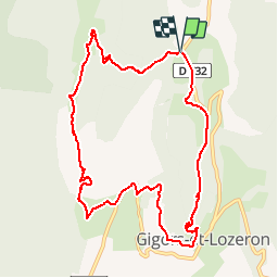
Tour Mountainbike von 11,2 km verfügbar auf Auvergne-Rhone-Alpen, Drôme, Gigors-et-Lozeron. Diese Tour wird von tracegps vorgeschlagen.
Beschreibung
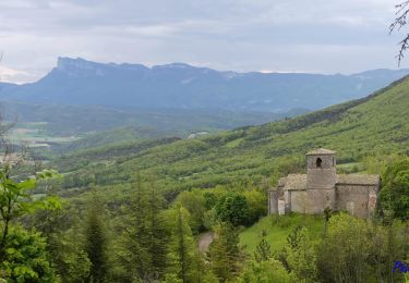
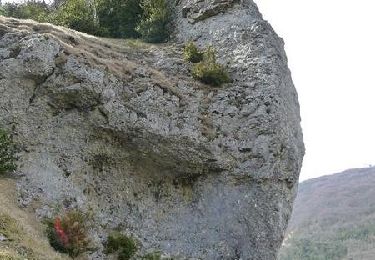
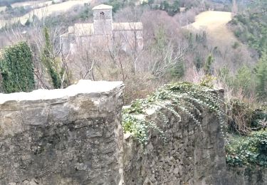
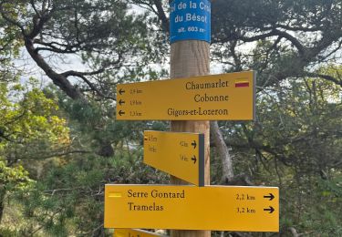
Départ de la rando au-dessus de Gigors, au domaine de Sagnol. Une balade variée, du rocher St Supière avec ses vaches highland aux ruines du Savel en passant par Gigors.
Ort
Land:
France
Region :
Auvergne-Rhone-Alpen
Abteilung/Provinz :
Drôme
Kommune :
Gigors-et-Lozeron
Standort:
Unknown
Gehen Sie:(Dec)
Gehen Sie:(UTM)
666361 ; 4964478 (31T) N.
Kommentare
Touren in der Umgebung
![Tour Wandern Gigors-et-Lozeron - Gigors - Saint-Supière - Photo](https://media.geolcdn.com/t/375/260/7a89f170-854d-4e76-988d-32a2f6e427fd.jpg&format=jpg&maxdim=2)
![Wandern Wandern](https://static1.geolcdn.com/sitytour/trail-icons/101.png)
Gigors - Saint-Supière
Wandern
Medium
(1)
Gigors-et-Lozeron,
Auvergne-Rhone-Alpen,
Drôme,
France
![](/images/other/stat-length.png)
11 km | 18,1 km-effort
4h 0min
![](https://static1.geolcdn.com/siteimages/upload/files/16400158638029165_repeat_loop_refresh_sync_direction_icon.png)
Ja
![Tour Wandern Gigors-et-Lozeron - St Supière et Savel à Gigors et Lozeron - Photo](https://media.geolcdn.com/t/375/260/ext.jpg?maxdim=2&url=https%3A%2F%2Fservices.sitytrail.com%2FGeolivesWS%2FDownloadMedia.ashx%3FTrailID%3D103208%26Media%3D5080_3.jpg)
![Wandern Wandern](https://static1.geolcdn.com/sitytour/trail-icons/101.png)
St Supière et Savel à Gigors et Lozeron
Wandern
Schwierig
(1)
Gigors-et-Lozeron,
Auvergne-Rhone-Alpen,
Drôme,
France
![](/images/other/stat-length.png)
11,2 km | 17,9 km-effort
4h 0min
![](https://static1.geolcdn.com/siteimages/upload/files/16400158638029165_repeat_loop_refresh_sync_direction_icon.png)
Ja
![Tour Wandern La Baume-Cornillane - Pas du Pont - Pas de la Croix - Pas du Buis - Photo](https://media.geolcdn.com/t/375/260/ext.jpg?maxdim=2&url=https%3A%2F%2Fservices.sitytrail.com%2FGeolivesWS%2FDownloadMedia.ashx%3FTrailID%3D99687%26Media%3D20120128162324.jpeg)
![Wandern Wandern](https://static1.geolcdn.com/sitytour/trail-icons/101.png)
Pas du Pont - Pas de la Croix - Pas du Buis
Wandern
Medium
(2)
La Baume-Cornillane,
Auvergne-Rhone-Alpen,
Drôme,
France
![](/images/other/stat-length.png)
10,3 km | 18 km-effort
2h 52min
![](https://static1.geolcdn.com/siteimages/upload/files/16400158638029165_repeat_loop_refresh_sync_direction_icon.png)
Ja
![Tour Wandern Beaufort-sur-Gervanne - 26 gervanne druise plan de baix - Photo](https://media.geolcdn.com/t/375/260/cef04867-033e-4aa7-8c70-c5079a2317fe.jpg&format=jpg&maxdim=2)
![Wandern Wandern](https://static1.geolcdn.com/sitytour/trail-icons/101.png)
26 gervanne druise plan de baix
Wandern
Medium
Beaufort-sur-Gervanne,
Auvergne-Rhone-Alpen,
Drôme,
France
![](/images/other/stat-length.png)
16,8 km | 23 km-effort
7h 57min
![](https://static1.geolcdn.com/siteimages/upload/files/16400158638029165_repeat_loop_refresh_sync_direction_icon.png)
Ja
![Tour Wandern Beaufort-sur-Gervanne - Beaufort St Pancrace 17km - Photo](https://media.geolcdn.com/t/375/260/ext.jpg?maxdim=2&url=https%3A%2F%2Fstatic1.geolcdn.com%2Fsiteimages%2Fupload%2Ffiles%2F1553511878bg_sport_marche.png)
![Wandern Wandern](https://static1.geolcdn.com/sitytour/trail-icons/101.png)
Beaufort St Pancrace 17km
Wandern
Medium
(1)
Beaufort-sur-Gervanne,
Auvergne-Rhone-Alpen,
Drôme,
France
![](/images/other/stat-length.png)
15 km | 21 km-effort
5h 0min
![](https://static1.geolcdn.com/siteimages/upload/files/16400158638029165_repeat_loop_refresh_sync_direction_icon.png)
Ja
![Tour Wandern Gigors-et-Lozeron - 26 st supporte gigors - Photo](https://media.geolcdn.com/t/375/260/c169c5cd-1ed9-4b41-908c-c962ab944e47.jpg&format=jpg&maxdim=2)
![Wandern Wandern](https://static1.geolcdn.com/sitytour/trail-icons/101.png)
26 st supporte gigors
Wandern
Medium
Gigors-et-Lozeron,
Auvergne-Rhone-Alpen,
Drôme,
France
![](/images/other/stat-length.png)
16 km | 24 km-effort
5h 8min
![](https://static1.geolcdn.com/siteimages/upload/files/16400158638029165_repeat_loop_refresh_sync_direction_icon.png)
Ja
![Tour Wandern La Baume-Cornillane - pas du pont - Photo](https://media.geolcdn.com/t/375/260/ext.jpg?maxdim=2&url=https%3A%2F%2Fstatic1.geolcdn.com%2Fsiteimages%2Fupload%2Ffiles%2F1553511878bg_sport_marche.png)
![Wandern Wandern](https://static1.geolcdn.com/sitytour/trail-icons/101.png)
pas du pont
Wandern
Einfach
(1)
La Baume-Cornillane,
Auvergne-Rhone-Alpen,
Drôme,
France
![](/images/other/stat-length.png)
6,9 km | 9,8 km-effort
3h 22min
![](https://static1.geolcdn.com/siteimages/upload/files/16400158638029165_repeat_loop_refresh_sync_direction_icon.png)
Ja
![Tour Wandern Gigors-et-Lozeron - 26 gigors zel 24.01.25 - Photo](https://media.geolcdn.com/t/375/260/6d773d26-45d9-491c-869c-836081a35829.jpg&format=jpg&maxdim=2)
![Wandern Wandern](https://static1.geolcdn.com/sitytour/trail-icons/101.png)
26 gigors zel 24.01.25
Wandern
Einfach
Gigors-et-Lozeron,
Auvergne-Rhone-Alpen,
Drôme,
France
![](/images/other/stat-length.png)
13,1 km | 21 km-effort
5h 59min
![](https://static1.geolcdn.com/siteimages/upload/files/16400158638029165_repeat_loop_refresh_sync_direction_icon.png)
Ja
![Tour sport Ourches - Ourches Cobonne col croix Bezot - Photo](https://media.geolcdn.com/t/375/260/c1f74f9b-903b-45f4-9039-e55a97ca2dd5.jpg&format=jpg&maxdim=2)
Ourches Cobonne col croix Bezot
sport
Sehr leicht
Ourches,
Auvergne-Rhone-Alpen,
Drôme,
France
![](/images/other/stat-length.png)
18,8 km | 32 km-effort
Unbekannt
![](https://static1.geolcdn.com/siteimages/upload/files/16400158638029165_repeat_loop_refresh_sync_direction_icon.png)
Ja