


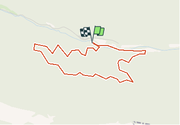

5 km | 6,7 km-effort

Benutzer


Kostenlosegpshiking-Anwendung
 SityTrail
IGN / Geografische Institute
SityTrail World
Die Welt öffnet sich für Sie
Tour Mountainbike von 4,6 km verfügbar auf Auvergne-Rhone-Alpen, Drôme, Saou. Diese Tour wird von tracegps vorgeschlagen.
Petite balade après un pique nique dans la prairie devant l'auberge des dauphins, deux heures forestières. Vous trouverez peut-être des champignons en saison ! C'est une rando casse-croûte, plus de détails au gîte du Pré bossu.


Wandern

Wandern

Wandern

Wandern

Wandern

Wandern

Rennrad

Wandern

Wandern