![](/images/other/stat-length.png)
![Tour Mountainbike Plaisir - Vtt Asso Raid 12 - Plaisir à Conflans Ste Honorine - Photo](https://media.geolcdn.com/t/1900/400/ext.pjpeg?maxdim=2&url=https%3A%2F%2Fservices.sitytrail.com%2FGeolivesWS%2FDownloadMedia.ashx%3FTrailID%3D103121%26Media%3D4869_2.jpg)
Vtt Asso Raid 12 - Plaisir à Conflans Ste Honorine
tracegps
Benutzer
![Länge](/images/other/stat-length.png)
Länge
94 km
![Maximale Höhe](https://static1.geolcdn.com/siteimages/upload/files/1508320355ic_sort_altitude_max_24dp.png)
Maximale Höhe
195 m
![Positive Höhendifferenz](https://static1.geolcdn.com/siteimages/upload/files/1508320355ic_sort_den_pos_24dp.png)
Positive Höhendifferenz
1092 m
![Km-Effort](/images/other/stat-length.png)
Km-Effort
108 km
![Min. Höhe](https://static1.geolcdn.com/siteimages/upload/files/1508320355ic_sort_altitude_min_24dp.png)
Min. Höhe
14 m
![Negative Höhendifferenz](https://static1.geolcdn.com/siteimages/upload/files/1508320355ic_sort_den_neg_24dp.png)
Negative Höhendifferenz
1084 m
![Boucle](https://static1.geolcdn.com/siteimages/upload/files/16400158638029165_repeat_loop_refresh_sync_direction_icon.png)
Boucle
Nein
Erstellungsdatum :
2014-12-10 00:00:00.0
Letzte Änderung :
2014-12-10 00:00:00.0
![Mountainbike](https://static1.geolcdn.com/sitytour/trail-icons/202.png)
7h30
Schwierigkeit : Sehr schwierig
![Scannen Sie diesen QR-Code, um die Tour in der SityTrail-Anwendung zu öffnen](https://capi.geolives.com/qq0zvz2zws4bq2lad0pu/sitytour/trails/103121/qr.png?size=200)
Kostenlosegpshiking-Anwendung
Über SityTrail
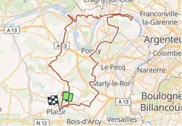
Tour Mountainbike von 94 km verfügbar auf Île-de-France, Yvelines, Plaisir. Diese Tour wird von tracegps vorgeschlagen.
Beschreibung
A faire de préférence du 1er Avril au 30 septembre, traversée de la Seine au niveau d'Herblay par le bac (gratuit, sinon raccourcir le parcours et enjamber la Seine à Conflans Sainte Honorine)
Ort
Land:
France
Region :
Île-de-France
Abteilung/Provinz :
Yvelines
Kommune :
Plaisir
Standort:
Unknown
Gehen Sie:(Dec)
Gehen Sie:(UTM)
423803 ; 5408421 (31U) N.
Kommentare
Touren in der Umgebung
![Tour Wandern Plaisir - Plaisir et forêt de Ste Apolline - Photo](https://media.geolcdn.com/t/375/260/ext.jpg?maxdim=2&url=https%3A%2F%2Fservices.sitytrail.com%2FGeolivesWS%2FDownloadMedia.ashx%3FTrailID%3D317587%26Media%3D16850_6.jpg)
![Wandern Wandern](https://static1.geolcdn.com/sitytour/trail-icons/101.png)
Plaisir et forêt de Ste Apolline
Wandern
Medium
(2)
Plaisir,
Île-de-France,
Yvelines,
France
![](/images/other/stat-length.png)
12,7 km | 15,4 km-effort
2h 30min
![](https://static1.geolcdn.com/siteimages/upload/files/16400158638029165_repeat_loop_refresh_sync_direction_icon.png)
Ja
![Tour Zu Fuß Chavenay - PR - Photo](https://media.geolcdn.com/t/375/260/f8e6bd7a-5875-409f-a50f-40b8535a7dfc.jpeg&format=jpg&maxdim=2)
![Zu Fuß Zu Fuß](https://static1.geolcdn.com/sitytour/trail-icons/100.png)
![Tour Wandern Villepreux - Rennemoulin villepreux - Photo](https://media.geolcdn.com/t/375/260/c6a93922-a7d6-4147-b00d-32cb6692839f.jpg&format=jpg&maxdim=2)
![Wandern Wandern](https://static1.geolcdn.com/sitytour/trail-icons/101.png)
Rennemoulin villepreux
Wandern
Medium
Villepreux,
Île-de-France,
Yvelines,
France
![](/images/other/stat-length.png)
9 km | 9,9 km-effort
2h 15min
![](https://static1.geolcdn.com/siteimages/upload/files/16400158638029165_repeat_loop_refresh_sync_direction_icon.png)
Ja
![Tour Wandern Bois-d'Arcy - 10342278-Tour du bois des Clayes - Photo](https://media.geolcdn.com/t/375/260/ext.jpg?maxdim=2&url=https%3A%2F%2Fstatic1.geolcdn.com%2Fsiteimages%2Fupload%2Ffiles%2F1553511878bg_sport_marche.png)
![Wandern Wandern](https://static1.geolcdn.com/sitytour/trail-icons/101.png)
10342278-Tour du bois des Clayes
Wandern
Medium
(1)
Bois-d'Arcy,
Île-de-France,
Yvelines,
France
![](/images/other/stat-length.png)
11,6 km | 13,4 km-effort
2h 56min
![](https://static1.geolcdn.com/siteimages/upload/files/16400158638029165_repeat_loop_refresh_sync_direction_icon.png)
Ja
![Tour Wandern Plaisir - Forêt de Ste Appoline - Photo](https://media.geolcdn.com/t/375/260/2403bab5-17fa-4962-9e74-0aac1e5009fd.jpg&format=jpg&maxdim=2)
![Wandern Wandern](https://static1.geolcdn.com/sitytour/trail-icons/101.png)
Forêt de Ste Appoline
Wandern
Medium
Plaisir,
Île-de-France,
Yvelines,
France
![](/images/other/stat-length.png)
18,1 km | 22 km-effort
5h 21min
![](https://static1.geolcdn.com/siteimages/upload/files/16400158638029165_repeat_loop_refresh_sync_direction_icon.png)
Ja
![Tour Andere Aktivitäten Chavenay - balade chavenay Yvelines - Photo](https://media.geolcdn.com/t/375/260/ext.jpg?maxdim=2&url=https%3A%2F%2Fservices.sitytrail.com%2FGeolivesWS%2FDownloadMedia.ashx%3FTrailID%3D1115221%26Media%3D20190224153940.jpg)
![Andere Aktivitäten Andere Aktivitäten](https://static1.geolcdn.com/sitytour/trail-icons/900.png)
balade chavenay Yvelines
Andere Aktivitäten
Sehr leicht
Chavenay,
Île-de-France,
Yvelines,
France
![](/images/other/stat-length.png)
3,1 km | 3,7 km-effort
1h 8min
![](https://static1.geolcdn.com/siteimages/upload/files/16400158638029165_repeat_loop_refresh_sync_direction_icon.png)
Ja
![Tour Wandern Élancourt - Elancourt 08/11/2018 - Photo](https://media.geolcdn.com/t/375/260/ext.jpg?maxdim=2&url=https%3A%2F%2Fservices.sitytrail.com%2FGeolivesWS%2FDownloadMedia.ashx%3FTrailID%3D1070716%26Media%3Dfix__20181108103614.jpg)
![Wandern Wandern](https://static1.geolcdn.com/sitytour/trail-icons/101.png)
Elancourt 08/11/2018
Wandern
Medium
Élancourt,
Île-de-France,
Yvelines,
France
![](/images/other/stat-length.png)
5,7 km | 6,6 km-effort
1h 33min
![](https://static1.geolcdn.com/siteimages/upload/files/16400158638029165_repeat_loop_refresh_sync_direction_icon.png)
Ja
![Tour Wandern Élancourt - Colline de la Revanche 17/05/2018 - Photo](https://media.geolcdn.com/t/375/260/ext.jpg?maxdim=2&url=https%3A%2F%2Fservices.sitytrail.com%2FGeolivesWS%2FDownloadMedia.ashx%3FTrailID%3D968049%26Media%3Dfix__20180517102719.jpg)
![Wandern Wandern](https://static1.geolcdn.com/sitytour/trail-icons/101.png)
Colline de la Revanche 17/05/2018
Wandern
Schwierig
Élancourt,
Île-de-France,
Yvelines,
France
![](/images/other/stat-length.png)
4,4 km | 5,8 km-effort
1h 27min
![](https://static1.geolcdn.com/siteimages/upload/files/16400158638029165_repeat_loop_refresh_sync_direction_icon.png)
Ja
![Tour Wandern Bois-d'Arcy - rando du 04/05/2017 - Photo](https://media.geolcdn.com/t/375/260/ext.jpg?maxdim=2&url=https%3A%2F%2Fservices.sitytrail.com%2FGeolivesWS%2FDownloadMedia.ashx%3FTrailID%3D746040%26Media%3Dfix__20170504112008.jpg)
![Wandern Wandern](https://static1.geolcdn.com/sitytour/trail-icons/101.png)
rando du 04/05/2017
Wandern
Medium
Bois-d'Arcy,
Île-de-France,
Yvelines,
France
![](/images/other/stat-length.png)
9,9 km | 11,3 km-effort
2h 18min
![](https://static1.geolcdn.com/siteimages/upload/files/16400158638029165_repeat_loop_refresh_sync_direction_icon.png)
Ja