![](/images/other/stat-length.png)
![Tour Wandern Wegscheid - Forêt des volcans à Wegscheid - Photo](https://media.geolcdn.com/t/1900/400/ext.pjpeg?maxdim=2&url=https%3A%2F%2Fservices.sitytrail.com%2FGeolivesWS%2FDownloadMedia.ashx%3FTrailID%3D103065%26Media%3D4702_6.jpg)
Forêt des volcans à Wegscheid
tracegps
Benutzer
![Länge](/images/other/stat-length.png)
![Maximale Höhe](https://static1.geolcdn.com/siteimages/upload/files/1508320355ic_sort_altitude_max_24dp.png)
![Positive Höhendifferenz](https://static1.geolcdn.com/siteimages/upload/files/1508320355ic_sort_den_pos_24dp.png)
![Km-Effort](/images/other/stat-length.png)
![Min. Höhe](https://static1.geolcdn.com/siteimages/upload/files/1508320355ic_sort_altitude_min_24dp.png)
![Negative Höhendifferenz](https://static1.geolcdn.com/siteimages/upload/files/1508320355ic_sort_den_neg_24dp.png)
![Boucle](https://static1.geolcdn.com/siteimages/upload/files/16400158638029165_repeat_loop_refresh_sync_direction_icon.png)
![Wandern](https://static1.geolcdn.com/sitytour/trail-icons/101.png)
4h00
Schwierigkeit : Medium
![Scannen Sie diesen QR-Code, um die Tour in der SityTrail-Anwendung zu öffnen](https://capi.geolives.com/qq0zvz2zws4bq2lad0pu/sitytour/trails/103065/qr.png?size=200)
Kostenlosegpshiking-Anwendung
Über SityTrail
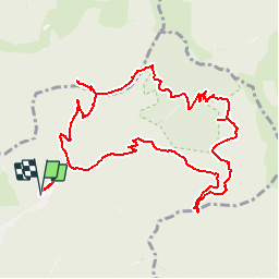
Tour Wandern von 11,4 km verfügbar auf Großer Osten, Oberelsass, Wegscheid. Diese Tour wird von tracegps vorgeschlagen.
Beschreibung
Beau circuit, principalement en forêt, parsemé de curiosités sur le plan géologique et agrémenté de superbes chalets-refuges. Accès en voiture : D466 en provenance de Masevaux, traverser le village de Wegscheid. A la sortie du village, prendre la route à droite sur environ 2km. Se garer sur un parking en contrebas d'un réservoir.
Ort
Kommentare
Touren in der Umgebung
![Tour Wandern Masevaux-Niederbruck - Masevaux - Rossberg par le belvédère du Fuchsfelsen - Photo](https://media.geolcdn.com/t/375/260/d9cc765c-1250-4953-9d9f-fb8b88eb82a7.jpg&format=jpg&maxdim=2)
![Wandern Wandern](https://static1.geolcdn.com/sitytour/trail-icons/101.png)
Wandern
![](/images/other/stat-length.png)
![](https://static1.geolcdn.com/siteimages/upload/files/16400158638029165_repeat_loop_refresh_sync_direction_icon.png)
![Tour Wandern Rimbach bei Masmünster - Haute Bers - Photo](https://media.geolcdn.com/t/375/260/263a149f-9c7c-4184-802a-631c78ca66f6.jpg&format=jpg&maxdim=2)
![Wandern Wandern](https://static1.geolcdn.com/sitytour/trail-icons/101.png)
Wandern
![](/images/other/stat-length.png)
![](https://static1.geolcdn.com/siteimages/upload/files/16400158638029165_repeat_loop_refresh_sync_direction_icon.png)
![Tour Wandern Sewen - Boucle entre les lacs de Sewen et d'Alfeld - Photo](https://media.geolcdn.com/t/375/260/ext.jpg?maxdim=2&url=https%3A%2F%2Fservices.sitytrail.com%2FGeolivesWS%2FDownloadMedia.ashx%3FTrailID%3D103686%26Media%3D6168_4.jpg)
![Wandern Wandern](https://static1.geolcdn.com/sitytour/trail-icons/101.png)
Wandern
![](/images/other/stat-length.png)
![](https://static1.geolcdn.com/siteimages/upload/files/16400158638029165_repeat_loop_refresh_sync_direction_icon.png)
![Tour Wandern Storckensohn - lac des perches marchettes - Photo](https://media.geolcdn.com/t/375/260/ba8e93c4-c66a-48b1-88b8-cca79cc3effc.jpg&format=jpg&maxdim=2)
![Wandern Wandern](https://static1.geolcdn.com/sitytour/trail-icons/101.png)
Wandern
![](/images/other/stat-length.png)
![](https://static1.geolcdn.com/siteimages/upload/files/16400158638029165_repeat_loop_refresh_sync_direction_icon.png)
![Tour Wandern Dolleren - suuntoapp-Hiking-2025-01-02T19-20-24Z - Photo](https://media.geolcdn.com/t/375/260/98b6c1e4-75f0-464a-86a1-edc427e75210.jpg&format=jpg&maxdim=2)
![Wandern Wandern](https://static1.geolcdn.com/sitytour/trail-icons/101.png)
Wandern
![](/images/other/stat-length.png)
![](https://static1.geolcdn.com/siteimages/upload/files/16400158638029165_repeat_loop_refresh_sync_direction_icon.png)
![Tour Wandern Storckensohn - 2022-07-16 Marche Auberge Gazon Vert Chapelle des Ves - Photo](https://media.geolcdn.com/t/375/260/7aac2105-88e6-44f1-a6d0-d41240d9f4c5.jpg&format=jpg&maxdim=2)
![Wandern Wandern](https://static1.geolcdn.com/sitytour/trail-icons/101.png)
Wandern
![](/images/other/stat-length.png)
![](https://static1.geolcdn.com/siteimages/upload/files/16400158638029165_repeat_loop_refresh_sync_direction_icon.png)
![Tour Wandern Kirchberg - 2022-07-15 Marche Refuge Baerenkopf Auberge Gazon Vert - Photo](https://media.geolcdn.com/t/375/260/d5c191fc-95a3-4bb1-8368-e694339cee76.jpg&format=jpg&maxdim=2)
![Wandern Wandern](https://static1.geolcdn.com/sitytour/trail-icons/101.png)
Wandern
![](/images/other/stat-length.png)
![](https://static1.geolcdn.com/siteimages/upload/files/16400158638029165_repeat_loop_refresh_sync_direction_icon.png)
![Tour Wandern Rimbach bei Masmünster - Les deux lacs - Photo](https://media.geolcdn.com/t/375/260/ec102df6-1fd0-42bb-8bbd-9523bd80f1a9.jpg&format=jpg&maxdim=2)
![Wandern Wandern](https://static1.geolcdn.com/sitytour/trail-icons/101.png)
Wandern
![](/images/other/stat-length.png)
![](https://static1.geolcdn.com/siteimages/upload/files/16400158638029165_repeat_loop_refresh_sync_direction_icon.png)
![Tour Wandern Wegscheid - FucksfelsenBelacker - Photo](https://media.geolcdn.com/t/375/260/ac608221-de91-4d0b-89a9-d4cab6086d15.jpg&format=jpg&maxdim=2)
![Wandern Wandern](https://static1.geolcdn.com/sitytour/trail-icons/101.png)
Wandern
![](/images/other/stat-length.png)
![](https://static1.geolcdn.com/siteimages/upload/files/16400158638029165_repeat_loop_refresh_sync_direction_icon.png)