![](/images/other/stat-length.png)
![Tour Mountainbike La Ferrière-aux-Étangs - Autour de Banvou - Photo](https://media.geolcdn.com/t/1900/400/ext.pjpeg?maxdim=2&url=https%3A%2F%2Fstatic1.geolcdn.com%2Fsiteimages%2Fupload%2Ffiles%2F1524743154velo.jpg)
Autour de Banvou
tracegps
Benutzer
![Länge](/images/other/stat-length.png)
Länge
32 km
![Maximale Höhe](https://static1.geolcdn.com/siteimages/upload/files/1508320355ic_sort_altitude_max_24dp.png)
Maximale Höhe
301 m
![Positive Höhendifferenz](https://static1.geolcdn.com/siteimages/upload/files/1508320355ic_sort_den_pos_24dp.png)
Positive Höhendifferenz
503 m
![Km-Effort](/images/other/stat-length.png)
Km-Effort
39 km
![Min. Höhe](https://static1.geolcdn.com/siteimages/upload/files/1508320355ic_sort_altitude_min_24dp.png)
Min. Höhe
154 m
![Negative Höhendifferenz](https://static1.geolcdn.com/siteimages/upload/files/1508320355ic_sort_den_neg_24dp.png)
Negative Höhendifferenz
503 m
![Boucle](https://static1.geolcdn.com/siteimages/upload/files/16400158638029165_repeat_loop_refresh_sync_direction_icon.png)
Boucle
Ja
Erstellungsdatum :
2014-12-10 00:00:00.0
Letzte Änderung :
2014-12-10 00:00:00.0
![Mountainbike](https://static1.geolcdn.com/sitytour/trail-icons/202.png)
2h30
Schwierigkeit : Medium
![Scannen Sie diesen QR-Code, um die Tour in der SityTrail-Anwendung zu öffnen](https://capi.geolives.com/qq0zvz2zws4bq2lad0pu/sitytour/trails/102965/qr.png?size=200)
Kostenlosegpshiking-Anwendung
Über SityTrail
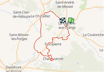
Tour Mountainbike von 32 km verfügbar auf Normandie, Orne, La Ferrière-aux-Étangs. Diese Tour wird von tracegps vorgeschlagen.
Beschreibung
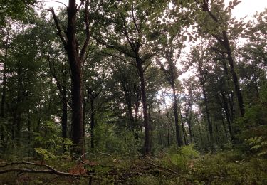
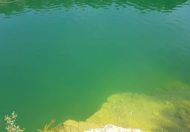
Boucle autour de Banvou. Point de Départ : dans le centre de La Ferrière aux Etangs, sur la digue en bout du plan d'eau. Parcourt varié alternant sous bois, chemins creux du bocage, Voie Verte et chemin en lisière de foret.
Ort
Land:
France
Region :
Normandie
Abteilung/Provinz :
Orne
Kommune :
La Ferrière-aux-Étangs
Standort:
Unknown
Gehen Sie:(Dec)
Gehen Sie:(UTM)
682721 ; 5392603 (30U) N.
Kommentare
Touren in der Umgebung
![Tour Wandern La Ferrière-aux-Étangs - Circuit of IRON by Yannick-p14-61 - Photo](https://media.geolcdn.com/t/375/260/e9109058-b6fa-4ee9-9d84-e1a504225bdf.jpg&format=jpg&maxdim=2)
![Wandern Wandern](https://static1.geolcdn.com/sitytour/trail-icons/101.png)
Circuit of IRON by Yannick-p14-61
Wandern
Medium
(1)
La Ferrière-aux-Étangs,
Normandie,
Orne,
France
![](/images/other/stat-length.png)
13,3 km | 16,5 km-effort
3h 35min
![](https://static1.geolcdn.com/siteimages/upload/files/16400158638029165_repeat_loop_refresh_sync_direction_icon.png)
Ja
![Tour Wandern La Coulonche - La coulonche - Photo](https://media.geolcdn.com/t/375/260/95c3eac8-30e6-4fa2-8846-ef805e476c7d.jpg&format=jpg&maxdim=2)
![Wandern Wandern](https://static1.geolcdn.com/sitytour/trail-icons/101.png)
La coulonche
Wandern
Sehr leicht
La Coulonche,
Normandie,
Orne,
France
![](/images/other/stat-length.png)
3,7 km | 4,9 km-effort
1h 22min
![](https://static1.geolcdn.com/siteimages/upload/files/16400158638029165_repeat_loop_refresh_sync_direction_icon.png)
Ja
![Tour Wandern La Ferrière-aux-Étangs - La Ferrière - La Ferrière aux Etangs - Photo](https://media.geolcdn.com/t/375/260/ext.jpg?maxdim=2&url=https%3A%2F%2Fservices.sitytrail.com%2FGeolivesWS%2FDownloadMedia.ashx%3FTrailID%3D111661%26Media%3D7899_2.jpg)
![Wandern Wandern](https://static1.geolcdn.com/sitytour/trail-icons/101.png)
La Ferrière - La Ferrière aux Etangs
Wandern
Medium
La Ferrière-aux-Étangs,
Normandie,
Orne,
France
![](/images/other/stat-length.png)
14,3 km | 17,9 km-effort
3h 4min
![](https://static1.geolcdn.com/siteimages/upload/files/16400158638029165_repeat_loop_refresh_sync_direction_icon.png)
Ja
![Tour Wandern La Ferrière-aux-Étangs - 1h16 - Photo](https://media.geolcdn.com/t/375/260/30fe1b0a-da55-41f8-8ede-6b74633fdbd3.jpg&format=jpg&maxdim=2)
![Wandern Wandern](https://static1.geolcdn.com/sitytour/trail-icons/101.png)
1h16
Wandern
Medium
La Ferrière-aux-Étangs,
Normandie,
Orne,
France
![](/images/other/stat-length.png)
6,4 km | 8,5 km-effort
1h 16min
![](https://static1.geolcdn.com/siteimages/upload/files/16400158638029165_repeat_loop_refresh_sync_direction_icon.png)
Ja
![Tour Wandern Le Châtellier - chatellier - Photo](https://media.geolcdn.com/t/375/260/ext.jpg?maxdim=2&url=https%3A%2F%2Fstatic1.geolcdn.com%2Fsiteimages%2Fupload%2Ffiles%2F1553511878bg_sport_marche.png)
![Wandern Wandern](https://static1.geolcdn.com/sitytour/trail-icons/101.png)
![Tour Wandern Dompierre - mines - Photo](https://media.geolcdn.com/t/375/260/ext.jpg?maxdim=2&url=https%3A%2F%2Fstatic1.geolcdn.com%2Fsiteimages%2Fupload%2Ffiles%2F1553511878bg_sport_marche.png)
![Wandern Wandern](https://static1.geolcdn.com/sitytour/trail-icons/101.png)
![Tour Wandern La Ferrière-aux-Étangs - La Feriere aux etant - Photo](https://media.geolcdn.com/t/375/260/f76f6a14-4f12-4d3c-ba5b-00c3b8cd2d26.jpg&format=jpg&maxdim=2)
![Wandern Wandern](https://static1.geolcdn.com/sitytour/trail-icons/101.png)
La Feriere aux etant
Wandern
Sehr leicht
La Ferrière-aux-Étangs,
Normandie,
Orne,
France
![](/images/other/stat-length.png)
1,2 km | 1,3 km-effort
36min
![](https://static1.geolcdn.com/siteimages/upload/files/16400158638029165_repeat_loop_refresh_sync_direction_icon.png)
Ja
![Tour Wandern Dompierre - Dompierre; trace GPS du 10/09/2019 - Photo](https://media.geolcdn.com/t/375/260/ext.jpg?maxdim=2&url=https%3A%2F%2Fstatic1.geolcdn.com%2Fsiteimages%2Fupload%2Ffiles%2F1553511878bg_sport_marche.png)
![Wandern Wandern](https://static1.geolcdn.com/sitytour/trail-icons/101.png)
Dompierre; trace GPS du 10/09/2019
Wandern
Sehr leicht
Dompierre,
Normandie,
Orne,
France
![](/images/other/stat-length.png)
8,2 km | 10,2 km-effort
4h 30min
![](https://static1.geolcdn.com/siteimages/upload/files/16400158638029165_repeat_loop_refresh_sync_direction_icon.png)
Ja
![Tour Wandern Dompierre - Dompierre longue - Photo](https://media.geolcdn.com/t/375/260/ext.jpg?maxdim=2&url=https%3A%2F%2Fstatic1.geolcdn.com%2Fsiteimages%2Fupload%2Ffiles%2F1553511878bg_sport_marche.png)
![Wandern Wandern](https://static1.geolcdn.com/sitytour/trail-icons/101.png)
Dompierre longue
Wandern
Medium
Dompierre,
Normandie,
Orne,
France
![](/images/other/stat-length.png)
8,3 km | 10 km-effort
2h 13min
![](https://static1.geolcdn.com/siteimages/upload/files/16400158638029165_repeat_loop_refresh_sync_direction_icon.png)
Ja