![](/images/other/stat-length.png)
![Tour Wandern Cergy - Etangs de Neuville - Photo](https://media.geolcdn.com/t/1900/400/ext.pjpeg?maxdim=2&url=https%3A%2F%2Fstatic1.geolcdn.com%2Fsiteimages%2Fupload%2Ffiles%2F1553511878bg_sport_marche.png)
Etangs de Neuville
tracegps
Benutzer
![Länge](/images/other/stat-length.png)
Länge
11,8 km
![Maximale Höhe](https://static1.geolcdn.com/siteimages/upload/files/1508320355ic_sort_altitude_max_24dp.png)
Maximale Höhe
83 m
![Positive Höhendifferenz](https://static1.geolcdn.com/siteimages/upload/files/1508320355ic_sort_den_pos_24dp.png)
Positive Höhendifferenz
129 m
![Km-Effort](/images/other/stat-length.png)
Km-Effort
13,5 km
![Min. Höhe](https://static1.geolcdn.com/siteimages/upload/files/1508320355ic_sort_altitude_min_24dp.png)
Min. Höhe
17 m
![Negative Höhendifferenz](https://static1.geolcdn.com/siteimages/upload/files/1508320355ic_sort_den_neg_24dp.png)
Negative Höhendifferenz
128 m
![Boucle](https://static1.geolcdn.com/siteimages/upload/files/16400158638029165_repeat_loop_refresh_sync_direction_icon.png)
Boucle
Ja
Erstellungsdatum :
2014-12-10 00:00:00.0
Letzte Änderung :
2014-12-10 00:00:00.0
![Wandern](https://static1.geolcdn.com/sitytour/trail-icons/101.png)
3h00
Schwierigkeit : Medium
![Scannen Sie diesen QR-Code, um die Tour in der SityTrail-Anwendung zu öffnen](https://capi.geolives.com/qq0zvz2zws4bq2lad0pu/sitytour/trails/102964/qr.png?size=200)
Kostenlosegpshiking-Anwendung
Über SityTrail
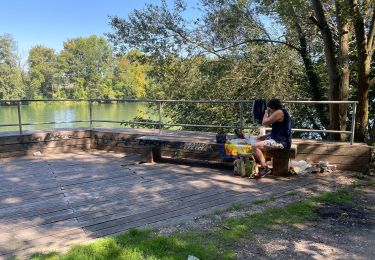
Tour Wandern von 11,8 km verfügbar auf Île-de-France, Val-d'Oise, Cergy. Diese Tour wird von tracegps vorgeschlagen.
Beschreibung
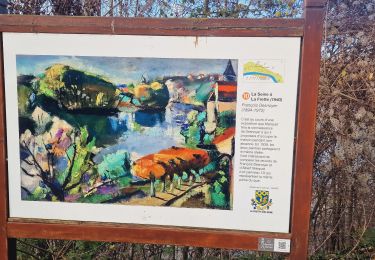
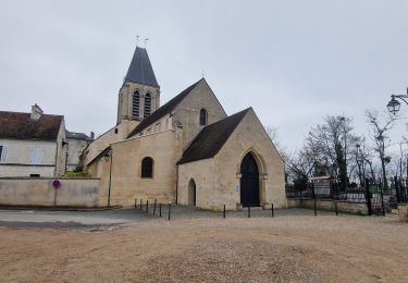
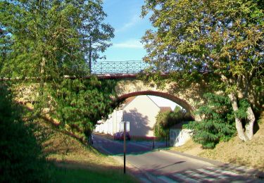
Circuit en boucle autour des étangs de Neuville. Passage par les villages de Jouy le Moutier et Vaureal. Balisage jaune(PR) et rouge et jaune (GRP). ATTENTION : Le stationnement dans Port Cergy est interdit les week-ends et le soir après 19h30. Randonnée sans grands dénivelés.
Ort
Land:
France
Region :
Île-de-France
Abteilung/Provinz :
Val-d'Oise
Kommune :
Cergy
Standort:
Unknown
Gehen Sie:(Dec)
Gehen Sie:(UTM)
431333 ; 5431484 (31U) N.
Kommentare
Touren in der Umgebung
![Tour Zu Fuß Conflans-Sainte-Honorine - Version définitive Conflans 7 janvier - Photo](https://media.geolcdn.com/t/375/260/2f5b666a-1419-402d-9c3e-8de986f24ebf.jpg&format=jpg&maxdim=2)
![Zu Fuß Zu Fuß](https://static1.geolcdn.com/sitytour/trail-icons/100.png)
Version définitive Conflans 7 janvier
Zu Fuß
Medium
(1)
Conflans-Sainte-Honorine,
Île-de-France,
Yvelines,
France
![](/images/other/stat-length.png)
23 km | 28 km-effort
6h 22min
![](https://static1.geolcdn.com/siteimages/upload/files/16400158638029165_repeat_loop_refresh_sync_direction_icon.png)
Nein
![Tour Wandern Pontoise - GRP CV-IDF 2023 - Photo](https://media.geolcdn.com/t/375/260/5cecfad9-3425-44be-8077-e3aed6f072e1.jpg&format=jpg&maxdim=2)
![Wandern Wandern](https://static1.geolcdn.com/sitytour/trail-icons/101.png)
GRP CV-IDF 2023
Wandern
Schwierig
(1)
Pontoise,
Île-de-France,
Val-d'Oise,
France
![](/images/other/stat-length.png)
15,3 km | 18,6 km-effort
4h 13min
![](https://static1.geolcdn.com/siteimages/upload/files/16400158638029165_repeat_loop_refresh_sync_direction_icon.png)
Nein
![Tour Wandern Jouy-le-Moutier - GRP CV-IDF 2023 - Photo](https://media.geolcdn.com/t/375/260/6d7dbb85-8194-44c4-a991-493315d817a9.jpg&format=jpg&maxdim=2)
![Wandern Wandern](https://static1.geolcdn.com/sitytour/trail-icons/101.png)
GRP CV-IDF 2023
Wandern
Schwierig
(1)
Jouy-le-Moutier,
Île-de-France,
Val-d'Oise,
France
![](/images/other/stat-length.png)
15,6 km | 18 km-effort
4h 4min
![](https://static1.geolcdn.com/siteimages/upload/files/16400158638029165_repeat_loop_refresh_sync_direction_icon.png)
Nein
![Tour Laufen Cergy - Les Bords de l'Oise et la Passerelle de l'Axe Majeur - Port Cergy - Photo](https://media.geolcdn.com/t/375/260/ext.jpg?maxdim=2&url=https%3A%2F%2Fservices.sitytrail.com%2FGeolivesWS%2FDownloadMedia.ashx%3FTrailID%3D118750%26Media%3D12946_6.jpg)
![Laufen Laufen](https://static1.geolcdn.com/sitytour/trail-icons/103.png)
Les Bords de l'Oise et la Passerelle de l'Axe Majeur - Port Cergy
Laufen
Einfach
(1)
Cergy,
Île-de-France,
Val-d'Oise,
France
![](/images/other/stat-length.png)
5,2 km | 5,8 km-effort
30min
![](https://static1.geolcdn.com/siteimages/upload/files/16400158638029165_repeat_loop_refresh_sync_direction_icon.png)
Ja
![Tour Zu Fuß Cergy - LES BALADES DE L’ÉTÉ # 9 / DE L’AXE MAJEUR À PORT CERGY - Photo](https://media.geolcdn.com/t/375/260/0abd8c0c-1f20-444a-8fa9-27c91da3cbd0.jpeg&format=jpg&maxdim=2)
![Zu Fuß Zu Fuß](https://static1.geolcdn.com/sitytour/trail-icons/100.png)
LES BALADES DE L’ÉTÉ # 9 / DE L’AXE MAJEUR À PORT CERGY
Zu Fuß
Sehr leicht
(1)
Cergy,
Île-de-France,
Val-d'Oise,
France
![](/images/other/stat-length.png)
6 km | 7,4 km-effort
1h 45min
![](https://static1.geolcdn.com/siteimages/upload/files/16400158638029165_repeat_loop_refresh_sync_direction_icon.png)
Ja
![Tour Zu Fuß Conflans-Sainte-Honorine - Conflans fin d'oise - Andresy - La Frette - Photo](https://media.geolcdn.com/t/375/260/43572d18-a869-49dd-98f4-125a083ecdd2.jpg&format=jpg&maxdim=2)
![Zu Fuß Zu Fuß](https://static1.geolcdn.com/sitytour/trail-icons/100.png)
Conflans fin d'oise - Andresy - La Frette
Zu Fuß
Medium
Conflans-Sainte-Honorine,
Île-de-France,
Yvelines,
France
![](/images/other/stat-length.png)
22 km | 27 km-effort
6h 14min
![](https://static1.geolcdn.com/siteimages/upload/files/16400158638029165_repeat_loop_refresh_sync_direction_icon.png)
Nein
![Tour Wandern Pontoise - Le tour du grand Paris via le GR1 Etape 5 Pontoise- L'isle Adam - Photo](https://media.geolcdn.com/t/375/260/07b6ba80-b018-4e04-a1a3-6a0196965773.jpg&format=jpg&maxdim=2)
![Wandern Wandern](https://static1.geolcdn.com/sitytour/trail-icons/101.png)
Le tour du grand Paris via le GR1 Etape 5 Pontoise- L'isle Adam
Wandern
Medium
Pontoise,
Île-de-France,
Val-d'Oise,
France
![](/images/other/stat-length.png)
32 km | 38 km-effort
6h 40min
![](https://static1.geolcdn.com/siteimages/upload/files/16400158638029165_repeat_loop_refresh_sync_direction_icon.png)
Nein
![Tour Zu Fuß Cergy - Le Fil d'Ariane - Photo](https://media.geolcdn.com/t/375/260/99555ae7-7473-4890-8cc1-181c61a69de2.jpeg&format=jpg&maxdim=2)
![Zu Fuß Zu Fuß](https://static1.geolcdn.com/sitytour/trail-icons/100.png)
Le Fil d'Ariane
Zu Fuß
Einfach
Cergy,
Île-de-France,
Val-d'Oise,
France
![](/images/other/stat-length.png)
3,2 km | 3,7 km-effort
50min
![](https://static1.geolcdn.com/siteimages/upload/files/16400158638029165_repeat_loop_refresh_sync_direction_icon.png)
Nein
![Tour Zu Fuß Cergy - Bords d'Oise Eragny - Port Cergy - Photo](https://media.geolcdn.com/t/375/260/b35f55a1-55cf-41a0-a75c-3f85248a60dd.jpeg&format=jpg&maxdim=2)
![Zu Fuß Zu Fuß](https://static1.geolcdn.com/sitytour/trail-icons/100.png)
Bords d'Oise Eragny - Port Cergy
Zu Fuß
Sehr leicht
(1)
Cergy,
Île-de-France,
Val-d'Oise,
France
![](/images/other/stat-length.png)
8 km | 8,7 km-effort
2h 0min
![](https://static1.geolcdn.com/siteimages/upload/files/16400158638029165_repeat_loop_refresh_sync_direction_icon.png)
Ja