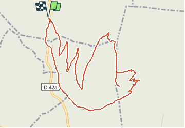
![](/images/other/stat-length.png)
![Tour Schneeschuhwandern Verthemex - Château Richard, depuis l'ancien stade de neige - Photo](https://media.geolcdn.com/t/1900/400/ext.pjpeg?maxdim=2&url=https%3A%2F%2Fservices.sitytrail.com%2FGeolivesWS%2FDownloadMedia.ashx%3FTrailID%3D102956%26Media%3D4348_1.jpg)
Château Richard, depuis l'ancien stade de neige
tracegps
Benutzer
![Länge](/images/other/stat-length.png)
![Maximale Höhe](https://static1.geolcdn.com/siteimages/upload/files/1508320355ic_sort_altitude_max_24dp.png)
![Positive Höhendifferenz](https://static1.geolcdn.com/siteimages/upload/files/1508320355ic_sort_den_pos_24dp.png)
![Km-Effort](/images/other/stat-length.png)
![Min. Höhe](https://static1.geolcdn.com/siteimages/upload/files/1508320355ic_sort_altitude_min_24dp.png)
![Negative Höhendifferenz](https://static1.geolcdn.com/siteimages/upload/files/1508320355ic_sort_den_neg_24dp.png)
![Boucle](https://static1.geolcdn.com/siteimages/upload/files/16400158638029165_repeat_loop_refresh_sync_direction_icon.png)
![Schneeschuhwandern](https://static1.geolcdn.com/sitytour/trail-icons/504.png)
2h45
Schwierigkeit : Einfach
![Scannen Sie diesen QR-Code, um die Tour in der SityTrail-Anwendung zu öffnen](https://capi.geolives.com/qq0zvz2zws4bq2lad0pu/sitytour/trails/102956/qr.png?size=200)
Kostenlosegpshiking-Anwendung
Über SityTrail
Tour Schneeschuhwandern von 6,9 km verfügbar auf Auvergne-Rhone-Alpen, Savoyen, Verthemex. Diese Tour wird von tracegps vorgeschlagen.
Beschreibung
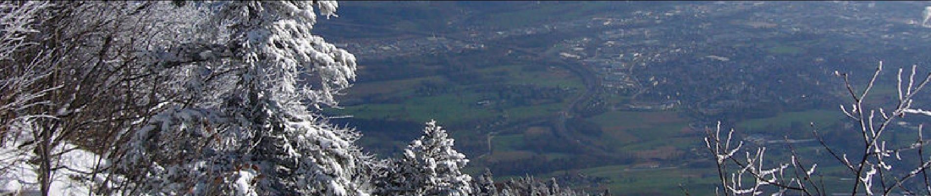
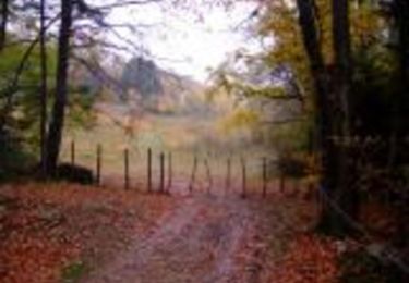
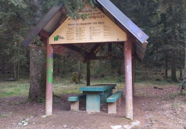
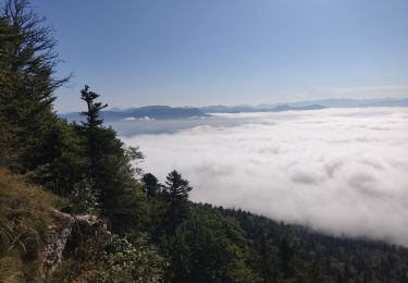
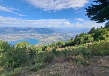
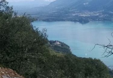
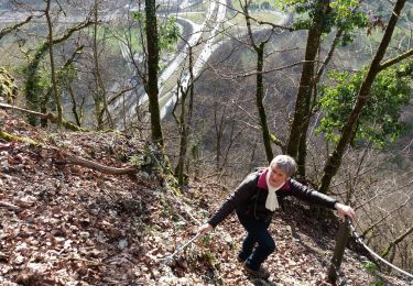
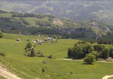
Randonnée à raquettes. Pour commencer la saison hivernale, la Montagne de l'Épine est idéale. En partant de l'ancien stade de neige de Verthemex, Château Richard et son belvédère constituent un objectif modeste mais agréable à atteindre par des pistes et sentiers forestiers. La montée qui traverse la Table des Princes emprunte le Passage Nord déjà décrit. Un aller et retour jusqu'au belvédère avant de monter vers la Pierre Gravée et descendre par la classique piste. Une variante par la trouée forestière de la remontée mécanique aujourd'hui démontée permet de rejoindre hors sentier le parking, point de départ sous le chalet restaurant. Description complète sur sentier-nature.com : Château Richard, depuis l'ancien stade de neige En randonnée, à pieds ou à raquettes, pour ne pas s'égarer à travers un paysage enneigé, carte 1/25000e, boussole et altimètre sont très utiles, surtout par temps de brouillard.
Ort
Kommentare
Touren in der Umgebung
![Tour Mountainbike Le Bourget-du-Lac - Chartreuse - Col du Crucifix - Photo](https://media.geolcdn.com/t/375/260/ext.jpg?maxdim=2&url=https%3A%2F%2Fservices.sitytrail.com%2FGeolivesWS%2FDownloadMedia.ashx%3FTrailID%3D102126%26Media%3D2516_1.jpg)
![Mountainbike Mountainbike](https://static1.geolcdn.com/sitytour/trail-icons/202.png)
Mountainbike
![](/images/other/stat-length.png)
![](https://static1.geolcdn.com/siteimages/upload/files/16400158638029165_repeat_loop_refresh_sync_direction_icon.png)
![Tour Pfad La Motte-Servolex - Château Richard et croix du Signal - Photo](https://media.geolcdn.com/t/375/260/3752241f-e62c-4bc8-86ee-aa981979bc96.jpg&format=jpg&maxdim=2)
![Pfad Pfad](https://static1.geolcdn.com/sitytour/trail-icons/104.png)
Pfad
![](/images/other/stat-length.png)
![](https://static1.geolcdn.com/siteimages/upload/files/16400158638029165_repeat_loop_refresh_sync_direction_icon.png)
![Tour Wandern La Motte-Servolex - 73 Croix du signal via Château Renard - Photo](https://media.geolcdn.com/t/375/260/b1ac2841-4f6c-4818-af5e-d71b85094992.jpg&format=jpg&maxdim=2)
![Wandern Wandern](https://static1.geolcdn.com/sitytour/trail-icons/101.png)
Wandern
![](/images/other/stat-length.png)
![](https://static1.geolcdn.com/siteimages/upload/files/16400158638029165_repeat_loop_refresh_sync_direction_icon.png)
![Tour Wandern Le Bourget-du-Lac - Dent du Chat, Mollard Noir, Refuge du Relais du Chat au départ du Sentier Botanique - Photo](https://media.geolcdn.com/t/375/260/89fa4c90-58f1-4891-bad5-9bd4924cd4f6.jpg&format=jpg&maxdim=2)
![Wandern Wandern](https://static1.geolcdn.com/sitytour/trail-icons/101.png)
Wandern
![](/images/other/stat-length.png)
![](https://static1.geolcdn.com/siteimages/upload/files/16400158638029165_repeat_loop_refresh_sync_direction_icon.png)
![Tour Wandern Nances - ballade vers Nances - Photo](https://media.geolcdn.com/t/375/260/08823fc1-7084-40fb-98e3-3a7cfdd25397.jpg&format=jpg&maxdim=2)
![Wandern Wandern](https://static1.geolcdn.com/sitytour/trail-icons/101.png)
Wandern
![](/images/other/stat-length.png)
![](https://static1.geolcdn.com/siteimages/upload/files/16400158638029165_repeat_loop_refresh_sync_direction_icon.png)
![Tour Wandern Le Bourget-du-Lac - mixte Pierre Nioule/croix du signal - Photo](https://media.geolcdn.com/t/375/260/c4b92019-89a6-4bfe-818d-fe93f3447b41.jpg&format=jpg&maxdim=2)
![Wandern Wandern](https://static1.geolcdn.com/sitytour/trail-icons/101.png)
Wandern
![](/images/other/stat-length.png)
![](https://static1.geolcdn.com/siteimages/upload/files/16400158638029165_repeat_loop_refresh_sync_direction_icon.png)
![Tour Rennrad Le Bourget-du-Lac - Tour du lac du Bourget par ontex - Photo](https://media.geolcdn.com/t/375/260/ff88a69a-20e5-4782-ac8d-3a72ff431962.jpg&format=jpg&maxdim=2)
![Rennrad Rennrad](https://static1.geolcdn.com/sitytour/trail-icons/201.png)
Rennrad
![](/images/other/stat-length.png)
![](https://static1.geolcdn.com/siteimages/upload/files/16400158638029165_repeat_loop_refresh_sync_direction_icon.png)
![Tour Wandern Nances - MONTAGNE DE L'EPINE: COTES DE NANCES - Photo](https://media.geolcdn.com/t/375/260/c3dee223-efc2-4a59-9795-9717356e4c79.jpg&format=jpg&maxdim=2)
![Wandern Wandern](https://static1.geolcdn.com/sitytour/trail-icons/101.png)
Wandern
![](/images/other/stat-length.png)
![](https://static1.geolcdn.com/siteimages/upload/files/16400158638029165_repeat_loop_refresh_sync_direction_icon.png)
![Tour Mountainbike La Motte-Servolex - Tour de l'OUTHERAN - Photo](https://media.geolcdn.com/t/375/260/ext.jpg?maxdim=2&url=https%3A%2F%2Fservices.sitytrail.com%2FGeolivesWS%2FDownloadMedia.ashx%3FTrailID%3D130091%26Media%3De1a453e2-c677-487b-a257-8d1ac541f956.jpg)
![Mountainbike Mountainbike](https://static1.geolcdn.com/sitytour/trail-icons/202.png)
Mountainbike
![](/images/other/stat-length.png)
![](https://static1.geolcdn.com/siteimages/upload/files/16400158638029165_repeat_loop_refresh_sync_direction_icon.png)