![](/images/other/stat-length.png)
![Tour Fahrrad Le Mérévillois - Méréville de la Juine à la Marette de Guillerval - Photo](https://media.geolcdn.com/t/1900/400/ext.pjpeg?maxdim=2&url=https%3A%2F%2Fstatic1.geolcdn.com%2Fsiteimages%2Fupload%2Ffiles%2F1524743154velo.jpg)
Méréville de la Juine à la Marette de Guillerval
tracegps
Benutzer
![Länge](/images/other/stat-length.png)
Länge
21 km
![Maximale Höhe](https://static1.geolcdn.com/siteimages/upload/files/1508320355ic_sort_altitude_max_24dp.png)
Maximale Höhe
141 m
![Positive Höhendifferenz](https://static1.geolcdn.com/siteimages/upload/files/1508320355ic_sort_den_pos_24dp.png)
Positive Höhendifferenz
278 m
![Km-Effort](/images/other/stat-length.png)
Km-Effort
25 km
![Min. Höhe](https://static1.geolcdn.com/siteimages/upload/files/1508320355ic_sort_altitude_min_24dp.png)
Min. Höhe
79 m
![Negative Höhendifferenz](https://static1.geolcdn.com/siteimages/upload/files/1508320355ic_sort_den_neg_24dp.png)
Negative Höhendifferenz
278 m
![Boucle](https://static1.geolcdn.com/siteimages/upload/files/16400158638029165_repeat_loop_refresh_sync_direction_icon.png)
Boucle
Ja
Erstellungsdatum :
2014-12-10 00:00:00.0
Letzte Änderung :
2014-12-10 00:00:00.0
![Fahrrad](https://static1.geolcdn.com/sitytour/trail-icons/200.png)
1h30
Schwierigkeit : Medium
![Scannen Sie diesen QR-Code, um die Tour in der SityTrail-Anwendung zu öffnen](https://capi.geolives.com/qq0zvz2zws4bq2lad0pu/sitytour/trails/102762/qr.png?size=200)
Kostenlosegpshiking-Anwendung
Über SityTrail
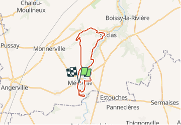
Tour Fahrrad von 21 km verfügbar auf Île-de-France, Essonne, Le Mérévillois. Diese Tour wird von tracegps vorgeschlagen.
Beschreibung
Méréville de la Juine à la Marette de Guillerval Par la route de la vallée, on rejoint Garsenval, Guillerval et Saclas. Puis on suit la Juine par la Croix St Aignan, la Tour Trajane et retour. Balade proposée par Tourisme Essonne.
Ort
Land:
France
Region :
Île-de-France
Abteilung/Provinz :
Essonne
Kommune :
Le Mérévillois
Standort:
Méréville
Gehen Sie:(Dec)
Gehen Sie:(UTM)
432276 ; 5351718 (31U) N.
Kommentare
Touren in der Umgebung
![Tour Wandern Le Mérévillois - Cressonnières et domaine départemental de Méréville - Photo](https://media.geolcdn.com/t/375/260/2d976ddb-4942-4108-b044-4564b8620dab.jpg&format=jpg&maxdim=2)
![Wandern Wandern](https://static1.geolcdn.com/sitytour/trail-icons/101.png)
Cressonnières et domaine départemental de Méréville
Wandern
Sehr leicht
Le Mérévillois,
Île-de-France,
Essonne,
France
![](/images/other/stat-length.png)
22 km | 25 km-effort
4h 51min
![](https://static1.geolcdn.com/siteimages/upload/files/16400158638029165_repeat_loop_refresh_sync_direction_icon.png)
Ja
![Tour Mountainbike Saclas - vtt2 - Photo](https://media.geolcdn.com/t/375/260/ext.jpg?maxdim=2&url=https%3A%2F%2Fstatic1.geolcdn.com%2Fsiteimages%2Fupload%2Ffiles%2F1524743154velo.jpg)
![Mountainbike Mountainbike](https://static1.geolcdn.com/sitytour/trail-icons/202.png)
vtt2
Mountainbike
Einfach
(1)
Saclas,
Île-de-France,
Essonne,
France
![](/images/other/stat-length.png)
4,9 km | 5,7 km-effort
Unbekannt
![](https://static1.geolcdn.com/siteimages/upload/files/16400158638029165_repeat_loop_refresh_sync_direction_icon.png)
Ja
![Tour Wandern Le Mérévillois - Méréville le long des cressonnières de la Juine - Photo](https://media.geolcdn.com/t/375/260/ext.jpg?maxdim=2&url=https%3A%2F%2Fservices.sitytrail.com%2FGeolivesWS%2FDownloadMedia.ashx%3FTrailID%3D102858%26Media%3D4034_3.jpg)
![Wandern Wandern](https://static1.geolcdn.com/sitytour/trail-icons/101.png)
Méréville le long des cressonnières de la Juine
Wandern
Medium
Le Mérévillois,
Île-de-France,
Essonne,
France
![](/images/other/stat-length.png)
10 km | 11,8 km-effort
3h 0min
![](https://static1.geolcdn.com/siteimages/upload/files/16400158638029165_repeat_loop_refresh_sync_direction_icon.png)
Ja
![Tour Wandern Le Mérévillois - mereville - Photo](https://media.geolcdn.com/t/375/260/ext.jpg?maxdim=2&url=https%3A%2F%2Fstatic1.geolcdn.com%2Fsiteimages%2Fupload%2Ffiles%2F1553511878bg_sport_marche.png)
![Wandern Wandern](https://static1.geolcdn.com/sitytour/trail-icons/101.png)
mereville
Wandern
Sehr schwierig
Le Mérévillois,
Île-de-France,
Essonne,
France
![](/images/other/stat-length.png)
22 km | 26 km-effort
5h 57min
![](https://static1.geolcdn.com/siteimages/upload/files/16400158638029165_repeat_loop_refresh_sync_direction_icon.png)
Ja
![Tour Mountainbike Saclas - vtt 1 - Photo](https://media.geolcdn.com/t/375/260/ext.jpg?maxdim=2&url=https%3A%2F%2Fstatic1.geolcdn.com%2Fsiteimages%2Fupload%2Ffiles%2F1524743154velo.jpg)
![Mountainbike Mountainbike](https://static1.geolcdn.com/sitytour/trail-icons/202.png)
vtt 1
Mountainbike
Sehr leicht
Saclas,
Île-de-France,
Essonne,
France
![](/images/other/stat-length.png)
7,3 km | 8,8 km-effort
Unbekannt
![](https://static1.geolcdn.com/siteimages/upload/files/16400158638029165_repeat_loop_refresh_sync_direction_icon.png)
Ja
![Tour Wandern Le Mérévillois - ormoy mereville - Photo](https://media.geolcdn.com/t/375/260/ext.jpg?maxdim=2&url=https%3A%2F%2Fstatic1.geolcdn.com%2Fsiteimages%2Fupload%2Ffiles%2F1553511878bg_sport_marche.png)
![Wandern Wandern](https://static1.geolcdn.com/sitytour/trail-icons/101.png)
ormoy mereville
Wandern
Sehr schwierig
Le Mérévillois,
Île-de-France,
Essonne,
France
![](/images/other/stat-length.png)
28 km | 33 km-effort
7h 24min
![](https://static1.geolcdn.com/siteimages/upload/files/16400158638029165_repeat_loop_refresh_sync_direction_icon.png)
Nein
![Tour Zu Fuß Le Mérévillois - Mérévillle à Ormoy-la-Rivière + les cressonières - Photo](https://media.geolcdn.com/t/375/260/ext.jpg?maxdim=2&url=https%3A%2F%2Fstatic1.geolcdn.com%2Fsiteimages%2Fupload%2Ffiles%2F1545311037marcheuse_200dpi.jpg)
![Zu Fuß Zu Fuß](https://static1.geolcdn.com/sitytour/trail-icons/100.png)
Mérévillle à Ormoy-la-Rivière + les cressonières
Zu Fuß
Schwierig
(1)
Le Mérévillois,
Île-de-France,
Essonne,
France
![](/images/other/stat-length.png)
28 km | 34 km-effort
7h 47min
![](https://static1.geolcdn.com/siteimages/upload/files/16400158638029165_repeat_loop_refresh_sync_direction_icon.png)
Nein
![Tour Wandern Le Mérévillois - De Méréville à Ormoy-la-Rivière - Photo](https://media.geolcdn.com/t/375/260/ext.jpg?maxdim=2&url=https%3A%2F%2Fstatic1.geolcdn.com%2Fsiteimages%2Fupload%2Ffiles%2F1553511878bg_sport_marche.png)
![Wandern Wandern](https://static1.geolcdn.com/sitytour/trail-icons/101.png)
De Méréville à Ormoy-la-Rivière
Wandern
Sehr schwierig
Le Mérévillois,
Île-de-France,
Essonne,
France
![](/images/other/stat-length.png)
22 km | 26 km-effort
5h 59min
![](https://static1.geolcdn.com/siteimages/upload/files/16400158638029165_repeat_loop_refresh_sync_direction_icon.png)
Nein
![Tour Wandern Le Mérévillois - 2024-05-15 Rando Méréville - Photo](https://media.geolcdn.com/t/375/260/ext.jpg?maxdim=2&url=https%3A%2F%2Fstatic1.geolcdn.com%2Fsiteimages%2Fupload%2Ffiles%2F1553511878bg_sport_marche.png)
![Wandern Wandern](https://static1.geolcdn.com/sitytour/trail-icons/101.png)
2024-05-15 Rando Méréville
Wandern
Einfach
Le Mérévillois,
Île-de-France,
Essonne,
France
![](/images/other/stat-length.png)
15,5 km | 18,4 km-effort
5h 43min
![](https://static1.geolcdn.com/siteimages/upload/files/16400158638029165_repeat_loop_refresh_sync_direction_icon.png)
Ja