![](/images/other/stat-length.png)
![Tour Mountainbike Langogne - Espace VTT FFC du Gévaudan - n°03 - Circuit des Huttes - Photo](https://media.geolcdn.com/t/1900/400/ext.pjpeg?maxdim=2&url=https%3A%2F%2Fservices.sitytrail.com%2FGeolivesWS%2FDownloadMedia.ashx%3FTrailID%3D102660%26Media%3D3669_1.jpg)
Espace VTT FFC du Gévaudan - n°03 - Circuit des Huttes
tracegps
Benutzer
![Länge](/images/other/stat-length.png)
![Maximale Höhe](https://static1.geolcdn.com/siteimages/upload/files/1508320355ic_sort_altitude_max_24dp.png)
![Positive Höhendifferenz](https://static1.geolcdn.com/siteimages/upload/files/1508320355ic_sort_den_pos_24dp.png)
![Km-Effort](/images/other/stat-length.png)
![Min. Höhe](https://static1.geolcdn.com/siteimages/upload/files/1508320355ic_sort_altitude_min_24dp.png)
![Negative Höhendifferenz](https://static1.geolcdn.com/siteimages/upload/files/1508320355ic_sort_den_neg_24dp.png)
![Boucle](https://static1.geolcdn.com/siteimages/upload/files/16400158638029165_repeat_loop_refresh_sync_direction_icon.png)
![Mountainbike](https://static1.geolcdn.com/sitytour/trail-icons/202.png)
3h15
Schwierigkeit : Schwierig
![Scannen Sie diesen QR-Code, um die Tour in der SityTrail-Anwendung zu öffnen](https://capi.geolives.com/qq0zvz2zws4bq2lad0pu/sitytour/trails/102660/qr.png?size=200)
Kostenlosegpshiking-Anwendung
Über SityTrail
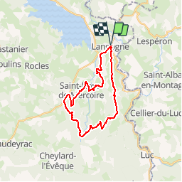
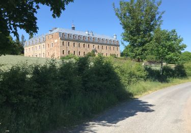
Tour Mountainbike von 25 km verfügbar auf Okzitanien, Lozère, Langogne. Diese Tour wird von tracegps vorgeschlagen.
Beschreibung
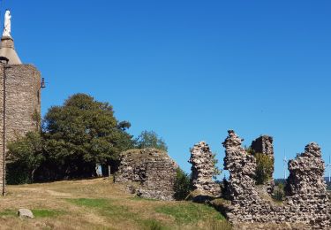
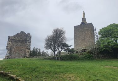
Espace VTT FFC Domaine VTT du Gévaudan Circuit labellisé par la Fédération Française de Cyclisme. Situé en plein coeur du Gévaudan, le domaine VTT s'étend sur 13 communes au départ de Langogne, du lac de Naussac au Moure de la Gardille, en passant par les gorges du Langouyrou ou de l'Allier, jusqu'aux hauts plateaux du Tartas, offrant une diversité incomparable de paysages somptueux et sauvages. Espace VTT FFC du Gévaudan - n°03 - Circuit des Huttes Passage par le village de Saint Flour de Mercoire et très belle descente dans les Gorges de Langouyrou juste après le Hameau des Huttes. Au retour, vous pourrez voir l’élevage de cerfs situé à Brugeyrolles. Carte détaillée des circuits en vente à l’Office du Tourisme de Langogne.
Ort
Kommentare
Touren in der Umgebung
![Tour Wandern Naussac-Fontanes - naussac - Photo](https://media.geolcdn.com/t/375/260/ext.jpg?maxdim=2&url=https%3A%2F%2Fservices.sitytrail.com%2FGeolivesWS%2FDownloadMedia.ashx%3FTrailID%3D208949%26Media%3Dfix__20130730162442.jpg)
![Wandern Wandern](https://static1.geolcdn.com/sitytour/trail-icons/101.png)
Wandern
![](/images/other/stat-length.png)
![](https://static1.geolcdn.com/siteimages/upload/files/16400158638029165_repeat_loop_refresh_sync_direction_icon.png)
![Tour Mountainbike Langogne - Espace VTT FFC du Gévaudan - n°08 - Circuit du Ras Chambon - Photo](https://media.geolcdn.com/t/375/260/ext.jpg?maxdim=2&url=https%3A%2F%2Fservices.sitytrail.com%2FGeolivesWS%2FDownloadMedia.ashx%3FTrailID%3D102665%26Media%3D3674_1.jpg)
![Mountainbike Mountainbike](https://static1.geolcdn.com/sitytour/trail-icons/202.png)
Mountainbike
![](/images/other/stat-length.png)
![](https://static1.geolcdn.com/siteimages/upload/files/16400158638029165_repeat_loop_refresh_sync_direction_icon.png)
![Tour Rennrad Langogne - Langogne, le nouveau monde - Photo](https://media.geolcdn.com/t/375/260/da33af3e-6429-4314-8b80-a9ce97f3ff9d.jpg&format=jpg&maxdim=2)
![Rennrad Rennrad](https://static1.geolcdn.com/sitytour/trail-icons/201.png)
Rennrad
![](/images/other/stat-length.png)
![](https://static1.geolcdn.com/siteimages/upload/files/16400158638029165_repeat_loop_refresh_sync_direction_icon.png)
![Tour Wandern Langogne - E4 Langogne - Luc GR70 - Photo](https://media.geolcdn.com/t/375/260/1c56381b-c00a-405a-bfd0-d26b1cee708f.jpg&format=jpg&maxdim=2)
![Wandern Wandern](https://static1.geolcdn.com/sitytour/trail-icons/101.png)
Wandern
![](/images/other/stat-length.png)
![](https://static1.geolcdn.com/siteimages/upload/files/16400158638029165_repeat_loop_refresh_sync_direction_icon.png)
![Tour Wandern Pradelles - Etape 3 Pradelles Haut cheylard l évêque - Photo](https://media.geolcdn.com/t/375/260/ce1558d8-841b-4f17-9992-c0d9828b0b71.jpg&format=jpg&maxdim=2)
![Wandern Wandern](https://static1.geolcdn.com/sitytour/trail-icons/101.png)
Wandern
![](/images/other/stat-length.png)
![](https://static1.geolcdn.com/siteimages/upload/files/16400158638029165_repeat_loop_refresh_sync_direction_icon.png)
![Tour Wandern Langogne - 09-05-2023 E4 Langogne - Luc - Photo](https://media.geolcdn.com/t/375/260/8aa4ecd6-c9b0-4973-b359-d5c3520516bf.jpg&format=jpg&maxdim=2)
![Wandern Wandern](https://static1.geolcdn.com/sitytour/trail-icons/101.png)
Wandern
![](/images/other/stat-length.png)
![](https://static1.geolcdn.com/siteimages/upload/files/16400158638029165_repeat_loop_refresh_sync_direction_icon.png)
![Tour Wandern Saint-Flour-de-Mercoire - le chélard - Photo](https://media.geolcdn.com/t/375/260/95b8db69-3dce-47bc-9f31-4efaab872b01.jpg&format=jpg&maxdim=2)
![Wandern Wandern](https://static1.geolcdn.com/sitytour/trail-icons/101.png)
Wandern
![](/images/other/stat-length.png)
![](https://static1.geolcdn.com/siteimages/upload/files/16400158638029165_repeat_loop_refresh_sync_direction_icon.png)
![Tour Wandern Saint-Flour-de-Mercoire - L’Herm Notre dame des neiges - Photo](https://media.geolcdn.com/t/375/260/1b1c5ae2-25c5-4141-8eeb-1c7365743d8a.jpg&format=jpg&maxdim=2)
![Wandern Wandern](https://static1.geolcdn.com/sitytour/trail-icons/101.png)
Wandern
![](/images/other/stat-length.png)
![](https://static1.geolcdn.com/siteimages/upload/files/16400158638029165_repeat_loop_refresh_sync_direction_icon.png)
![Tour Rennrad Langogne - NAUSSAC - COL DE LA PIERRE PLANTEE - Photo](https://media.geolcdn.com/t/375/260/ea2ac3d2-069e-4639-8ab2-1f7be14e0b5b.jpg&format=jpg&maxdim=2)
![Rennrad Rennrad](https://static1.geolcdn.com/sitytour/trail-icons/201.png)
Rennrad
![](/images/other/stat-length.png)
![](https://static1.geolcdn.com/siteimages/upload/files/16400158638029165_repeat_loop_refresh_sync_direction_icon.png)