![](/images/other/stat-length.png)
![Tour Mountainbike Longeville-lès-Metz - Le long de la Moselle - Photo](https://media.geolcdn.com/t/1900/400/ext.pjpeg?maxdim=2&url=https%3A%2F%2Fservices.sitytrail.com%2FGeolivesWS%2FDownloadMedia.ashx%3FTrailID%3D102620%26Media%3D3559_1.jpg)
Le long de la Moselle
tracegps
Benutzer
![Länge](/images/other/stat-length.png)
Länge
19,2 km
![Maximale Höhe](https://static1.geolcdn.com/siteimages/upload/files/1508320355ic_sort_altitude_max_24dp.png)
Maximale Höhe
175 m
![Positive Höhendifferenz](https://static1.geolcdn.com/siteimages/upload/files/1508320355ic_sort_den_pos_24dp.png)
Positive Höhendifferenz
123 m
![Km-Effort](/images/other/stat-length.png)
Km-Effort
21 km
![Min. Höhe](https://static1.geolcdn.com/siteimages/upload/files/1508320355ic_sort_altitude_min_24dp.png)
Min. Höhe
160 m
![Negative Höhendifferenz](https://static1.geolcdn.com/siteimages/upload/files/1508320355ic_sort_den_neg_24dp.png)
Negative Höhendifferenz
124 m
![Boucle](https://static1.geolcdn.com/siteimages/upload/files/16400158638029165_repeat_loop_refresh_sync_direction_icon.png)
Boucle
Ja
Erstellungsdatum :
2014-12-10 00:00:00.0
Letzte Änderung :
2014-12-10 00:00:00.0
![Mountainbike](https://static1.geolcdn.com/sitytour/trail-icons/202.png)
2h00
Schwierigkeit : Einfach
![Scannen Sie diesen QR-Code, um die Tour in der SityTrail-Anwendung zu öffnen](https://capi.geolives.com/qq0zvz2zws4bq2lad0pu/sitytour/trails/102620/qr.png?size=200)
Kostenlosegpshiking-Anwendung
Über SityTrail
Tour Mountainbike von 19,2 km verfügbar auf Großer Osten, Mosel, Longeville-lès-Metz. Diese Tour wird von tracegps vorgeschlagen.
Beschreibung
Balade agréable et tranquille en vélo sans aucune difficulté, idéal pour sortir entre amis ou en couple. Le départ se situe au Lac Symphony en plein centre ville. Rien de tel pour les amoureux ;)
Ort
Land:
France
Region :
Großer Osten
Abteilung/Provinz :
Mosel
Kommune :
Longeville-lès-Metz
Standort:
Unknown
Gehen Sie:(Dec)
Gehen Sie:(UTM)
292921 ; 5444202 (32U) N.
Kommentare
Touren in der Umgebung
![Tour Wandern Papolsheim - Saint Quentin - Photo](https://media.geolcdn.com/t/375/260/ext.jpg?maxdim=2&url=https%3A%2F%2Fservices.sitytrail.com%2FGeolivesWS%2FDownloadMedia.ashx%3FTrailID%3D159776%26Media%3D20121024120133.jpg)
![Wandern Wandern](https://static1.geolcdn.com/sitytour/trail-icons/101.png)
Saint Quentin
Wandern
Medium
(1)
Papolsheim,
Großer Osten,
Mosel,
France
![](/images/other/stat-length.png)
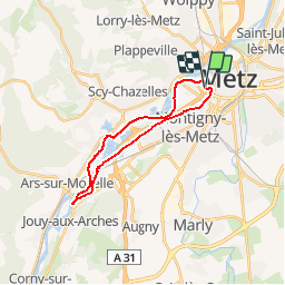
6,9 km | 9,2 km-effort
1h 59min
![](https://static1.geolcdn.com/siteimages/upload/files/16400158638029165_repeat_loop_refresh_sync_direction_icon.png)
Ja
![Tour Wandern Papolsheim - Autour du fort de Plappeville. - Photo](https://media.geolcdn.com/t/375/260/ext.jpg?maxdim=2&url=https%3A%2F%2Fservices.sitytrail.com%2FGeolivesWS%2FDownloadMedia.ashx%3FTrailID%3D147559%26Media%3D20120816102740.jpg)
![Wandern Wandern](https://static1.geolcdn.com/sitytour/trail-icons/101.png)
Autour du fort de Plappeville.
Wandern
Einfach
(1)
Papolsheim,
Großer Osten,
Mosel,
France
![](/images/other/stat-length.png)
8,9 km | 11 km-effort
2h 55min
![](https://static1.geolcdn.com/siteimages/upload/files/16400158638029165_repeat_loop_refresh_sync_direction_icon.png)
Ja
![Tour Zu Fuß Metz - Circuit des sentiers de Queuleu - Photo](https://media.geolcdn.com/t/375/260/e8f5cc79-0435-4c0e-abc8-879d05da612b.jpeg&format=jpg&maxdim=2)
![Zu Fuß Zu Fuß](https://static1.geolcdn.com/sitytour/trail-icons/100.png)
Circuit des sentiers de Queuleu
Zu Fuß
Einfach
Metz,
Großer Osten,
Mosel,
France
![](/images/other/stat-length.png)
4,5 km | 5,2 km-effort
1h 10min
![](https://static1.geolcdn.com/siteimages/upload/files/16400158638029165_repeat_loop_refresh_sync_direction_icon.png)
Ja
![Tour Zu Fuß Scy-Chazelles - Circuit Robert Schuman - Photo](https://media.geolcdn.com/t/375/260/7afac14e-8e32-42d2-8dfe-26d9e6a8df51.jpeg&format=jpg&maxdim=2)
![Zu Fuß Zu Fuß](https://static1.geolcdn.com/sitytour/trail-icons/100.png)
Circuit Robert Schuman
Zu Fuß
Einfach
Scy-Chazelles,
Großer Osten,
Mosel,
France
![](/images/other/stat-length.png)
3,5 km | 5 km-effort
1h 7min
![](https://static1.geolcdn.com/siteimages/upload/files/16400158638029165_repeat_loop_refresh_sync_direction_icon.png)
Nein
![Tour Zu Fuß Scy-Chazelles - Circuit du Tour du Mont St Quentin - Photo](https://media.geolcdn.com/t/375/260/0227a6bb-ecc7-41f2-b92a-b603e3858c5b.jpeg&format=jpg&maxdim=2)
![Zu Fuß Zu Fuß](https://static1.geolcdn.com/sitytour/trail-icons/100.png)
Circuit du Tour du Mont St Quentin
Zu Fuß
Einfach
Scy-Chazelles,
Großer Osten,
Mosel,
France
![](/images/other/stat-length.png)
4,9 km | 6,7 km-effort
1h 31min
![](https://static1.geolcdn.com/siteimages/upload/files/16400158638029165_repeat_loop_refresh_sync_direction_icon.png)
Nein
![Wandern Wandern](https://static1.geolcdn.com/sitytour/trail-icons/101.png)
20210723 - METZ - Promenade des remparts - 6 Km
Wandern
Sehr leicht
Metz,
Großer Osten,
Mosel,
France
![](/images/other/stat-length.png)
5,7 km | 6,6 km-effort
1h 45min
![](https://static1.geolcdn.com/siteimages/upload/files/16400158638029165_repeat_loop_refresh_sync_direction_icon.png)
Ja
![Tour Wandern Saulny - plesnois - Photo](https://media.geolcdn.com/t/375/260/30dd64af-04ad-4ba2-adb2-9542b50b478b.jpg&format=jpg&maxdim=2)
![Wandern Wandern](https://static1.geolcdn.com/sitytour/trail-icons/101.png)
![Tour Mountainbike Metz - MetzGare-PAM - Photo](https://media.geolcdn.com/t/375/260/ext.jpg?maxdim=2&url=https%3A%2F%2Fstatic1.geolcdn.com%2Fsiteimages%2Fupload%2Ffiles%2F1524743154velo.jpg)
![Mountainbike Mountainbike](https://static1.geolcdn.com/sitytour/trail-icons/202.png)
MetzGare-PAM
Mountainbike
Einfach
(1)
Metz,
Großer Osten,
Mosel,
France
![](/images/other/stat-length.png)
30 km | 33 km-effort
Unbekannt
![](https://static1.geolcdn.com/siteimages/upload/files/16400158638029165_repeat_loop_refresh_sync_direction_icon.png)
Nein
![Tour Wandern Longeville-lès-Metz - Metz - Les fortifications & 🎅🎄 - Photo](https://media.geolcdn.com/t/375/260/78c4f220-2684-42e2-8e51-0cc7754dd491.jpg&format=jpg&maxdim=2)
![Wandern Wandern](https://static1.geolcdn.com/sitytour/trail-icons/101.png)
Metz - Les fortifications & 🎅🎄
Wandern
Einfach
Longeville-lès-Metz,
Großer Osten,
Mosel,
France
![](/images/other/stat-length.png)
11,2 km | 12,9 km-effort
2h 41min
![](https://static1.geolcdn.com/siteimages/upload/files/16400158638029165_repeat_loop_refresh_sync_direction_icon.png)
Ja